Accessibility

Font Size

100% 150% 200%

Background Colour

Default Contrast
Close Reset

Abbeymill Farm, Burial Ground

Burial Ground (Post Medieval), Gravestone (17th Century)

Site Name Abbeymill Farm, Burial Ground

Classification Burial Ground (Post Medieval), Gravestone (17th Century)

Canmore ID 56585

Site Number NT57SW 9

NGR NT 5348 7469

Datum OSGB36 - NGR

Permalink http://canmore.org.uk/site/56585

Ordnance Survey licence number AC0000807262. All rights reserved.
Canmore Disclaimer. © Bluesky International Limited 2025. Public Sector Viewing Terms

Toggle Aerial | View on large map

Digital Images

Oblique aerial view centred on the burial-ground, watermill, farmhouse, farmsteading and school, and the cropmarks of the nunnery, taken from the NE.
Oblique aerial view centred on the burial-ground, watermill, farmhouse, farmsteading and school, and the cropmarks of the nunnery, taken from the NE.Oblique aerial photographOblique aerial view centred on the burial-ground, watermill, farmhouse, farmsteading and school, and the cropmarks of the nunnery, taken from the SE.Oblique aerial photographAbbeymill, oblique aerial view, taken from the SSE, centred on cropmarks. Further cropmarks and the sites of St Mary's nunnery and a burial-ground are visible in the centre left of the photograph.Abbeymill, oblique aerial view, taken from the NE, centred on cropmarks. Further cropmarks, and the sites of St Mary's nunnery and a burial-ground, and Abbey Mill, are visible in the top left-hand corner of the photograph.Oblique aerial view centred on the burial-ground, watermill, farmhouse, farmsteading and school, and the cropmarks of the nunnery, taken from the SW.Oblique aerial view centred on the burial-ground, watermill, farmhouse, farmsteading and school, and the cropmarks of the nunnery, taken from the ESE.Oblique aerial view centred on the burial-ground, watermill, farmhouse, farmsteading and school, and the cropmarks of the nunnery, taken from the NE.Oblique aerial view centred on the cropmarks of the nunnery with the burial-ground and the watermill and kiln adjacent, taken from the W.Abbeymill, oblique aerial view, taken from the E, centred on cropmarks. Further cropmarks, and the sites of St Mary's nunnery and a burial-ground, and Abbeymill Farm, are visible in the top half of the photograph.Oblique aerial view.Oblique aerial view of centred on Abbeymill Farm and graveyard with the site of the nunnery adjacent.Oblique aerial view.Oblique aerial photographOblique aerial view centred on the burial-ground, watermill, farmhouse, farmsteading and school, and the cropmarks of the nunnery, taken from the NE.Oblique aerial view centred on the burial-ground, watermill, farmhouse, farmsteading and school, and the cropmarks of the nunnery, taken from the NNW.Oblique aerial view centred on the burial-ground, watermill, farmhouse and farmsteading, and the cropmarks of the nunnery, taken from the S.Oblique aerial view centred on the cropmarks of the nunnery with the burial-ground and the watermill and kiln adjacent, taken from the SW.Oblique aerial photographOblique aerial view centred on the cropmarks with the burial-ground, the farmhouse and the watermill and kiln adjacent, taken from the ESE.Abbeymill Farm, Burial Ground, NT57SW 9, Ordnance Survey index card, page number 1, RectoOblique aerial view.Oblique aerial photographOblique aerial photographOblique aerial photographOblique aerial view of centred on Abbeymill Farm and graveyard with the site of the nunnery adjacent.Oblique aerial photographOblique aerial view.Oblique aerial view centred on the burial-ground, watermill, farmhouse, farmsteading and school, and the cropmarks of the nunnery, taken from the NE.Oblique aerial view.

Administrative Areas

  • Council East Lothian
  • Parish Haddington
  • Former Region Lothian
  • Former District East Lothian
  • Former County East Lothian

Archaeology Notes

NT57SW 9 5348 7469.

(NT 5348 7469) Burial Ground (NR)

OS 6" map (1969)

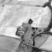
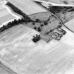
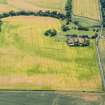
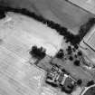
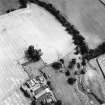
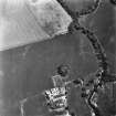
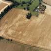
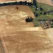
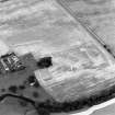
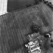
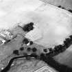
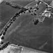
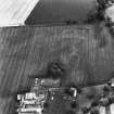
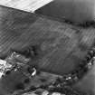
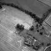
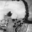
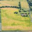
This burial ground lies within an oblong wooded enclosure; at its E end are two greatly weathered table stones, with illegible inscriptions, and on the S is a 17th century headstone.

The Ordnance Survey Name Book [ONB] states that this burial ground was associated with the nearby St Mary's Nunnery (NT57SW 10).

RCAHMS 1924, visited 1913; Name Book 1853

The enclosing wall of the burial ground has been demolished, leaving a long, mutilated, low mound rising above the surrounding ground level. The burial ground is wooded; the stones mentioned above are still in evidence.

Visited by OS (BS) 7 Julu 1975.

Activities

Field Visit (1 July 1913)

Some 70 yards east of the Abbey Farm (RCAHMS 1924, No. 79) in an oblong wooded enclosure is a graveyard in a state of desolation. At the eastern end are two table stones greatly weathered, with illegible inscriptions. On the south is a 17th century headstone bearing the funereal insignia of the period.

RCAHMS 1924, 1 July 1913.

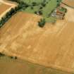
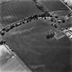
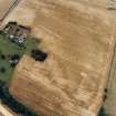
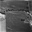
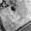
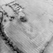
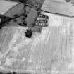
Earth Resistance Survey (6 February 2022)

NT 5348 7468 On 6 February 2022 a further six 20 x 20m grids (2400m2) were surveyed to the N and E of the previous survey of 2013 on an arable field S of the burial ground of St Mary’s Convent. A rectangular high resistance anomaly to the N of the 2013 survey area may represent part of another possible structure associated with an early Christian abbey or convent. A rectangular anomaly to the SE may be the location of a doocot.

Archive: NRHE and East Lothian Council HER

Funder: Haddington’s History Society, Edinburgh Archaeological Field Society, Private individual

Ian Hawkins – Edinburgh Archaeological Field Society

(Source: DES Volume 23)

References

MyCanmore Image Contributions


Contribute an Image

MyCanmore Text Contributions