
Bolton


Fort (Period Unassigned)
Site Name Bolton
Classification Fort (Period Unassigned)
Canmore ID 56527
Site Number NT57SW 38
NGR NT 50544 70369
Datum OSGB36 - NGR
Permalink http://canmore.org.uk/site/56527


- Council East Lothian
- Parish Bolton
- Former Region Lothian
- Former District East Lothian
- Former County East Lothian
NT57SW 38 NT 50544 70369
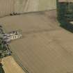
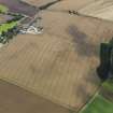
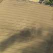
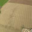
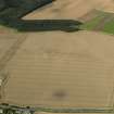
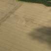
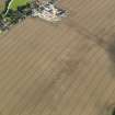
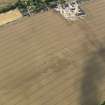
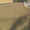
(NT 5054 7036) A sub-circular earthwork comprising three concentric ditches and measuring overall about 190.0m E-W by 115.0m is visible on air photographs (SDD: 6416/CN/B2, B3).
The feature is very similar to the settlement nearby (NT57SW 31).
(Undated) information in NMRS.
There is nothing visible in a field under wheat.
Site surveyed at 1:10560 from air photographs.
Visited by OS (BS) 8 July 1975
Additional air photographs have been taken by CUCAP and by the RCAHMS. This feature is listed by CUCAP as a 'native settlement' and by the RCAHMS as a 'fort'.
(Undated) information in NMRS.
Note (18 December 2015 - 20 October 2016)
Cropmarks have revealed the site of a complex fort occupying the summit of the low hill above Bolton. The most coherent element of the defences is a belt of three roughly concentric ditches swinging round the NE, SE and SW flanks. On the NW, however, no fewer than five lines are visible on the aerial photographs, and of these only the outermost can be correlated to the rest of the circuit with complete confidence, pierced by entrances on the NNE and SW respectively. In contrast, the innermost on the NW, clearly intersects the belt of defences on the NNE, re-emerging between the inner and middle ditches on this side, as does the second line, though this latter may also correlate to the innermost round the rest of the circuit. Evidently the confused appearance of the cropmarks is the result of the eccentric superimposition of two separate enclosures, both of roughly the same size, the one oval on plan within the two narrow ditches or possibly massive palisade trenches visible on the NW and an entrance on the SW, and the other sub-oval, measuring 90m from NE to SW by 80m transversely (0.56ha) within the three ditches visible elsewhere. None of these ditches is particularly broad, typically measuring no more than 2m in breadth, but the belt they form is between 22m and 26m deep, expanding to 30m at the entrance on the NNE. And while the outermost appears the broadest, in places up to 4m in breadth, the ragged outline of its W terminal at the N entrance suggests it is a composite mark hiding several recut lines; likewise at the SW entrance, where a spur of the ditch on the NW side of the gap doglegs sharply outwards to create an overlap with the opposite ditch terminal, this spur ditch is no more than 2m in breadth. Undoubtedly, however, the defences are more complex than this simple resolution of the sequence into two separate perimeters, and there are traces of other linear features, some of them possibly palisade trenches, but also including two segments of a broad ragged mark between the second and fourth lines on the NW. No clear features are visible within the interior, but one macula on the S probably marks the stance of a timber round-house.
Information from An Atlas of Hillforts of Great Britain and Ireland – 20 October 2016. Atlas of Hillforts SC3886

