Accessibility

Font Size

100% 150% 200%

Background Colour

Default Contrast
Close Reset

St Mary's Nunnery

Nunnery (Period Unassigned)

Site Name St Mary's Nunnery

Classification Nunnery (Period Unassigned)

Alternative Name(s) Abbeymill Farm

Canmore ID 56492

Site Number NT57SW 10

NGR NT 53613 74731

Datum OSGB36 - NGR

Permalink http://canmore.org.uk/site/56492

Ordnance Survey licence number AC0000807262. All rights reserved.
Canmore Disclaimer. © Bluesky International Limited 2025. Public Sector Viewing Terms

Toggle Aerial | View on large map

Digital Images

Oblique aerial view centred on the burial-ground, watermill, farmhouse, farmsteading and school, and the cropmarks of the nunnery, taken from the NE.
Oblique aerial view centred on the burial-ground, watermill, farmhouse, farmsteading and school, and the cropmarks of the nunnery, taken from the NE.Oblique aerial photographOblique aerial view centred on the burial-ground, watermill, farmhouse, farmsteading and school, and the cropmarks of the nunnery, taken from the SE.Oblique aerial photographAbbeymill, oblique aerial view, taken from the SSE, centred on cropmarks. Further cropmarks and the sites of St Mary's nunnery and a burial-ground are visible in the centre left of the photograph.Abbeymill, oblique aerial view, taken from the NE, centred on cropmarks. Further cropmarks, and the sites of St Mary's nunnery and a burial-ground, and Abbey Mill, are visible in the top left-hand corner of the photograph.Oblique aerial view centred on the burial-ground, watermill, farmhouse, farmsteading and school, and the cropmarks of the nunnery, taken from the SW.Oblique aerial view centred on the burial-ground, watermill, farmhouse, farmsteading and school, and the cropmarks of the nunnery, taken from the ESE.Oblique aerial view centred on the burial-ground, watermill, farmhouse, farmsteading and school, and the cropmarks of the nunnery, taken from the NE.Oblique aerial view centred on the cropmarks of the nunnery with the burial-ground and the watermill and kiln adjacent, taken from the W.Abbeymill, oblique aerial view, taken from the E, centred on cropmarks. Further cropmarks, and the sites of St Mary's nunnery and a burial-ground, and Abbeymill Farm, are visible in the top half of the photograph.Oblique aerial view.Oblique aerial view of centred on Abbeymill Farm and graveyard with the site of the nunnery adjacent.Oblique aerial view.Oblique aerial photographOblique aerial view centred on the burial-ground, watermill, farmhouse, farmsteading and school, and the cropmarks of the nunnery, taken from the NE.Oblique aerial view centred on the burial-ground, watermill, farmhouse, farmsteading and school, and the cropmarks of the nunnery, taken from the NNW.Oblique aerial view centred on the burial-ground, watermill, farmhouse and farmsteading, and the cropmarks of the nunnery, taken from the S.Oblique aerial view centred on the cropmarks of the nunnery with the burial-ground and the watermill and kiln adjacent, taken from the SW.Oblique aerial photographOblique aerial view centred on the cropmarks with the burial-ground, the farmhouse and the watermill and kiln adjacent, taken from the ESE.St Mary's Nunnery, NT57SW 10, Ordnance Survey index card, page number 1, RectoOblique aerial view.Oblique aerial photographOblique aerial photographOblique aerial photographOblique aerial view of centred on Abbeymill Farm and graveyard with the site of the nunnery adjacent.Oblique aerial photographOblique aerial view.Oblique aerial view centred on the burial-ground, watermill, farmhouse, farmsteading and school, and the cropmarks of the nunnery, taken from the NE.Oblique aerial view.

Administrative Areas

  • Council East Lothian
  • Parish Haddington
  • Former Region Lothian
  • Former District East Lothian
  • Former County East Lothian

Archaeology Notes

NT57SW 10 NT 53613 74731

See also NT57SW 5 and NT57SW 9.

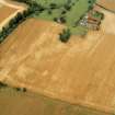
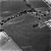
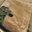
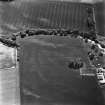
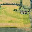
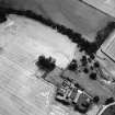
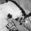
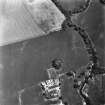
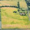
(NT 5345 7466) Site of St Mary's Nunnery (NR) (Cistercian)

OS 6" map (1969)

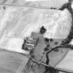
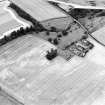
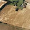
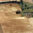
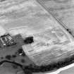
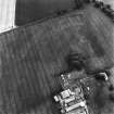
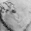
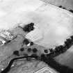
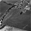
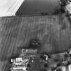
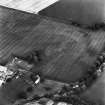
This was one of the largest Scottish nunneries. It was founded by Ada, countess of Northumberland and Huntingdon, for Cistercian nuns, before 1159. It was burned by the English in 1335/6 and in 1554, and was secularised in 1621. Though no trace of it remained in 1853, remains were extant within living memory, and the site was pointed out by local informants who could remember them.

I B Cowan and D E Easson 1976; Name Book 1853; D E Easson and G Donaldson 1955

There is nothing to be seen at the published site though the farmer, Mr Steadman, Abbeymill Farm, states that the ground in the vicinity is very stony.

Visited by OS (BS) 7 July 1975

Activities

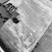
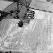
Aerial Photographic Transcription (8 December 1995 - 15 January 1998)

An aerial transcription was produced from oblique aerial photographs. Information from Historic Environment Scotland (BM) 31 March 2017.

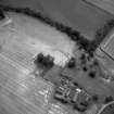
Earth Resistance Survey (27 April 2013)

NT 53613 74731 A geophysical survey was undertaken on 27 April 2013, at the request of Haddington’s History Society, of a 2400m2 area of arable land at Abbeyhill Farm on the site of St Mary’s Nunnery. This was one of the largest Scottish nunneries, founded by Ada, Countess of Northumberland and Huntingdon, for Cistercian nuns, before 1159 and closed in 1621. The survey identified an L-shaped higher resistance anomaly located to the S of the graveyard measuring 28m E–W and 13m N–S at its widest point. Traces of possible outlying structures were also noted.

Archive: East Lothian HER and RCAHMS (intended)

Funder: Russell Trust, Haddington’s History Society and Edinburgh Archaeological Field Society

Ian Hawkins, Edinburgh Archaeological Field Society, 2013

(Source: DES)

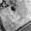
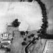
Aerial Photographic Transcription (1 August 2019)

An interpretative transcription, or mapping, of information on oblique aerial photographs was produced on 1 August 2019.

References

MyCanmore Image Contributions


Contribute an Image

MyCanmore Text Contributions