|
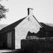
Photographs and Off-line Digital Images |
EL 6976 |
List C Survey |
View from W of farmhouse. |
1975 |
Item Level |
|
|
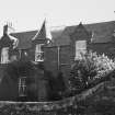
Photographs and Off-line Digital Images |
EL 6977 |
List C Survey |
View from SW of steading. |
1975 |
Item Level |
|
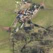 |
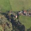
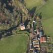
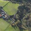
On-line Digital Images |
DP 062564 |
RCAHMS Aerial Photography Digital |
Oblique aerial view of Stoneypath Tower with farmstead adjacent, taken from the NNW. |
31/3/2009 |
Item Level |
|
 |
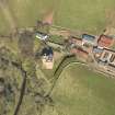
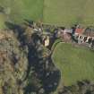
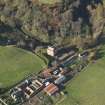
On-line Digital Images |
DP 062565 |
RCAHMS Aerial Photography Digital |
Oblique aerial view of Stoneypath Tower with farmstead adjacent, taken from the WNW. |
31/3/2009 |
Item Level |
|
 |
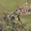
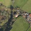
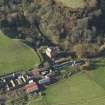
On-line Digital Images |
DP 062566 |
RCAHMS Aerial Photography Digital |
Oblique aerial view of Stoneypath Tower with farmstead adjacent, taken from the SW. |
31/3/2009 |
Item Level |
|
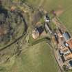 |
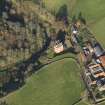
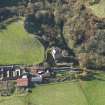
On-line Digital Images |
DP 062567 |
RCAHMS Aerial Photography Digital |
Oblique aerial view of Stoneypath Tower with farmstead adjacent, taken from the SSW. |
31/3/2009 |
Item Level |
|
 |
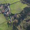
On-line Digital Images |
DP 073772 |
RCAHMS Aerial Photography Digital |
Oblique aerial view centred on the tower house with the farmstead adjacent, taken from the W. |
4/11/2009 |
Item Level |
|
 |
On-line Digital Images |
DP 073773 |
RCAHMS Aerial Photography Digital |
Oblique aerial view centred on the tower house with the farmstead adjacent, taken from the SW. |
4/11/2009 |
Item Level |
|
 |
On-line Digital Images |
DP 073774 |
RCAHMS Aerial Photography Digital |
Oblique aerial view centred on the tower house with the farmstead adjacent, taken from the SSW. |
4/11/2009 |
Item Level |
|
 |
On-line Digital Images |
DP 073775 |
RCAHMS Aerial Photography Digital |
Oblique aerial view centred on the tower house with the farmstead adjacent, taken from the S. |
4/11/2009 |
Item Level |
|
 |
On-line Digital Images |
DP 073776 |
RCAHMS Aerial Photography Digital |
Oblique aerial view centred on the tower house with the farmstead adjacent, taken from the SSE. |
4/11/2009 |
Item Level |
|
 |
On-line Digital Images |
DP 073778 |
RCAHMS Aerial Photography Digital |
Oblique aerial view centred on the tower house with the farmstead adjacent, taken from the SE. |
4/11/2009 |
Item Level |
|
 |
On-line Digital Images |
DP 073779 |
RCAHMS Aerial Photography Digital |
Oblique aerial view centred on the tower house with the farmstead adjacent, taken from the ESE. |
4/11/2009 |
Item Level |
|
 |
On-line Digital Images |
DP 073780 |
RCAHMS Aerial Photography Digital |
Oblique aerial view centred on the tower house with the farmstead adjacent, taken from the E. |
4/11/2009 |
Item Level |
|
 |
On-line Digital Images |
DP 073781 |
RCAHMS Aerial Photography Digital |
Oblique aerial view centred on the tower house with the farmstead adjacent, taken from the NE. |
4/11/2009 |
Item Level |
|
 |
On-line Digital Images |
DP 073782 |
RCAHMS Aerial Photography Digital |
Oblique aerial view centred on the tower house with the farmstead adjacent, taken from the N. |
4/11/2009 |
Item Level |
|
 |
On-line Digital Images |
SC 1645607 |
List C Survey |
View from W of farmhouse. |
1975 |
Item Level |
|
 |
On-line Digital Images |
SC 1645608 |
List C Survey |
View from SW of steading. |
1975 |
Item Level |
|
 |
On-line Digital Images |
SC 2451147 |
Records of the Ordnance Survey, Southampton, Hampshire, England |
Stoneypath, NT57SE 67, Ordnance Survey index card, Recto |
1958 |
Item Level |
|
|
All Other |
551 104/11/4 |
Records from Headland Archaeology Ltd, archaeologists, Edinburgh, Scotland |
Archive from a desk-assessment, excavation and building recording at Stoneypath Tower, by Garvald, East Lothian (SPT 99), by Headland Archaeology Ltd, 1999-2001. |
1999 |
Sub-Group Level |
|


