
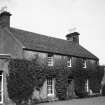
Whittingehame Mains


Farmhouse (Late 18th Century)
Site Name Whittingehame Mains
Classification Farmhouse (Late 18th Century)
Alternative Name(s) Whittingehame Mains
Canmore ID 56462
Site Number NT57SE 66
NGR NT 59763 73731
NGR Description Centred on NT 59805 73765
Datum OSGB36 - NGR
Permalink http://canmore.org.uk/site/56462
Ordnance Survey licence number AC0000807262. All rights reserved.
Canmore Disclaimer.
© Bluesky International Limited 2025. Public Sector Viewing Terms
- Correction
- Favourite

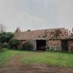
SC 1370212
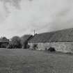
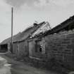
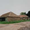
NE Range and dairy buildings. View from ESE
Records of the Royal Commission on the Ancient and Historical Monuments of Scotland (RCAHMS), Edinbu
21/4/2004
© Crown Copyright: HES

SC 2589613
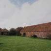
Approach avenue. View from SE
Records of the Royal Commission on the Ancient and Historical Monuments of Scotland (RCAHMS), Edinbu
21/4/2004
© Crown Copyright: HES

SC 2589637
NE Range and dairy buildings. View from ESE
Records of the Royal Commission on the Ancient and Historical Monuments of Scotland (RCAHMS), Edinbu
21/4/2004
© Crown Copyright: HES

SC 2589641
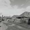
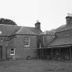
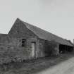
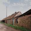
Dairy buildings and garage. View from NE
Records of the Royal Commission on the Ancient and Historical Monuments of Scotland (RCAHMS), Edinbu
21/4/2004
© Crown Copyright: HES

SC 1370197
Approach avenue. View from SE
Records of the Royal Commission on the Ancient and Historical Monuments of Scotland (RCAHMS), Edinbu
21/4/2004
© Crown Copyright: HES

SC 1370203
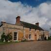
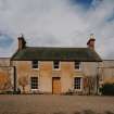
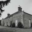
View from E
Records of the Royal Commission on the Ancient and Historical Monuments of Scotland (RCAHMS), Edinbu
21/4/2004
© Crown Copyright: HES

SC 1370204
View from NNE
Records of the Royal Commission on the Ancient and Historical Monuments of Scotland (RCAHMS), Edinbu
21/4/2004
© Crown Copyright: HES

SC 1370213
Dairy buildings and NE Range. View from W
Records of the Royal Commission on the Ancient and Historical Monuments of Scotland (RCAHMS), Edinbu
21/4/2004
© Crown Copyright: HES

SC 1370214
Dairy buildings and garage. View from NE
Records of the Royal Commission on the Ancient and Historical Monuments of Scotland (RCAHMS), Edinbu
21/4/2004
© Crown Copyright: HES

SC 2589632
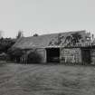
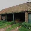
Dairy buildings. View from SSE
Records of the Royal Commission on the Ancient and Historical Monuments of Scotland (RCAHMS), Edinbu
21/4/2004
© Crown Copyright: HES

SC 2589636
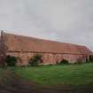
NE Range. View from NE
Records of the Royal Commission on the Ancient and Historical Monuments of Scotland (RCAHMS), Edinbu
21/4/2004
© Crown Copyright: HES

SC 2589639
Dairy buildings and NE Range. View from W
Records of the Royal Commission on the Ancient and Historical Monuments of Scotland (RCAHMS), Edinbu
21/4/2004
© Crown Copyright: HES

SC 1370209
Dairy buildings. View from SSE
Records of the Royal Commission on the Ancient and Historical Monuments of Scotland (RCAHMS), Edinbu
21/4/2004
© Crown Copyright: HES

SC 2589627
Dairy buildings. View from SSE
Records of the Royal Commission on the Ancient and Historical Monuments of Scotland (RCAHMS), Edinbu
21/4/2004
© Crown Copyright: HES

SC 1370200
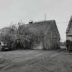
View from S
Records of the Royal Commission on the Ancient and Historical Monuments of Scotland (RCAHMS), Edinbu
21/4/2004
© Crown Copyright: HES

SC 1370201
View from SE
Records of the Royal Commission on the Ancient and Historical Monuments of Scotland (RCAHMS), Edinbu
21/4/2004
© Crown Copyright: HES

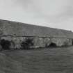
SC 1370207
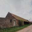
Dairy buildings. Cartshed. View from NW
Records of the Royal Commission on the Ancient and Historical Monuments of Scotland (RCAHMS), Edinbu
21/4/2004
© Crown Copyright: HES

SC 2451146
Whittingehame Mains, NT57SE 66, Ordnance Survey index card, Recto
Records of the Ordnance Survey, Southampton, Hampshire, England
c. 1958
© Crown Copyright: HES (Ordnance Survey Archaeology Division)

SC 2589614
Approach avenue. View from SE
Records of the Royal Commission on the Ancient and Historical Monuments of Scotland (RCAHMS), Edinbu
21/4/2004
© Crown Copyright: HES

SC 2589617
View from S
Records of the Royal Commission on the Ancient and Historical Monuments of Scotland (RCAHMS), Edinbu
21/4/2004
© Crown Copyright: HES

SC 2589618
View from S
Records of the Royal Commission on the Ancient and Historical Monuments of Scotland (RCAHMS), Edinbu
21/4/2004
© Crown Copyright: HES

SC 2589622
View from ESE
Records of the Royal Commission on the Ancient and Historical Monuments of Scotland (RCAHMS), Edinbu
21/4/2004
© Crown Copyright: HES

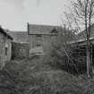
SC 2589628
Dairy buildings. View from WNW
Records of the Royal Commission on the Ancient and Historical Monuments of Scotland (RCAHMS), Edinbu
21/4/2004
© Crown Copyright: HES

SC 2589638
NE Range and dairy buildings. View from ESE
Records of the Royal Commission on the Ancient and Historical Monuments of Scotland (RCAHMS), Edinbu
21/4/2004
© Crown Copyright: HES

SC 1370196
Approach avenue. View from SE
Records of the Royal Commission on the Ancient and Historical Monuments of Scotland (RCAHMS), Edinbu
21/4/2004
© Crown Copyright: HES

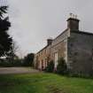
SC 1370210
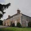
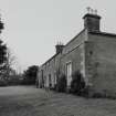
NE Range. View from S
Records of the Royal Commission on the Ancient and Historical Monuments of Scotland (RCAHMS), Edinbu
21/4/2004
© Crown Copyright: HES

SC 1370211
NE Range. View from NE
Records of the Royal Commission on the Ancient and Historical Monuments of Scotland (RCAHMS), Edinbu
21/4/2004
© Crown Copyright: HES

SC 2589615
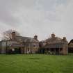
General view from S
Records of the Royal Commission on the Ancient and Historical Monuments of Scotland (RCAHMS), Edinbu
21/4/2004
© Crown Copyright: HES

SC 2589620
View from SE
Records of the Royal Commission on the Ancient and Historical Monuments of Scotland (RCAHMS), Edinbu
21/4/2004
© Crown Copyright: HES

SC 2589630
Dairy buildings. Cartshed. View from NW
Records of the Royal Commission on the Ancient and Historical Monuments of Scotland (RCAHMS), Edinbu
21/4/2004
© Crown Copyright: HES

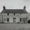
SC 1370199
General view from S
Records of the Royal Commission on the Ancient and Historical Monuments of Scotland (RCAHMS), Edinbu
21/4/2004
© Crown Copyright: HES

SC 1370206
Dairy buildings. View from WNW
Records of the Royal Commission on the Ancient and Historical Monuments of Scotland (RCAHMS), Edinbu
21/4/2004
© Crown Copyright: HES

SC 2589616
General view from S
Records of the Royal Commission on the Ancient and Historical Monuments of Scotland (RCAHMS), Edinbu
21/4/2004
© Crown Copyright: HES

SC 2589619
View from SE
Records of the Royal Commission on the Ancient and Historical Monuments of Scotland (RCAHMS), Edinbu
21/4/2004
© Crown Copyright: HES

SC 2589624
View from E
Records of the Royal Commission on the Ancient and Historical Monuments of Scotland (RCAHMS), Edinbu
21/4/2004
© Crown Copyright: HES

SC 2589631
Dairy buildings. Courtyard. View from SW
Records of the Royal Commission on the Ancient and Historical Monuments of Scotland (RCAHMS), Edinbu
21/4/2004
© Crown Copyright: HES

SC 2589633
NE Range. View from S
Records of the Royal Commission on the Ancient and Historical Monuments of Scotland (RCAHMS), Edinbu
21/4/2004
© Crown Copyright: HES

SC 1370198
Approach avenue and gatepiers. View from NW
Records of the Royal Commission on the Ancient and Historical Monuments of Scotland (RCAHMS), Edinbu
21/4/2004
© Crown Copyright: HES

SC 1370202
View from ESE
Records of the Royal Commission on the Ancient and Historical Monuments of Scotland (RCAHMS), Edinbu
21/4/2004
© Crown Copyright: HES

SC 1370208
Dairy buildings. Courtyard. View from SW
Records of the Royal Commission on the Ancient and Historical Monuments of Scotland (RCAHMS), Edinbu
21/4/2004
© Crown Copyright: HES


SC 2589621
View from ESE
Records of the Royal Commission on the Ancient and Historical Monuments of Scotland (RCAHMS), Edinbu
21/4/2004
© Crown Copyright: HES

SC 2589623
View from E
Records of the Royal Commission on the Ancient and Historical Monuments of Scotland (RCAHMS), Edinbu
21/4/2004
© Crown Copyright: HES

SC 2589625
View from NNE
Records of the Royal Commission on the Ancient and Historical Monuments of Scotland (RCAHMS), Edinbu
21/4/2004
© Crown Copyright: HES

SC 2589626
View from NNE
Records of the Royal Commission on the Ancient and Historical Monuments of Scotland (RCAHMS), Edinbu
21/4/2004
© Crown Copyright: HES

SC 2589629
Dairy buildings. Cartshed. View from NW
Records of the Royal Commission on the Ancient and Historical Monuments of Scotland (RCAHMS), Edinbu
21/4/2004
© Crown Copyright: HES

SC 2589634
NE Range. View from S
Records of the Royal Commission on the Ancient and Historical Monuments of Scotland (RCAHMS), Edinbu
21/4/2004
© Crown Copyright: HES

SC 2589635
NE Range. View from NE
Records of the Royal Commission on the Ancient and Historical Monuments of Scotland (RCAHMS), Edinbu
21/4/2004
© Crown Copyright: HES

SC 2589640
Dairy buildings and NE Range. View from W
Records of the Royal Commission on the Ancient and Historical Monuments of Scotland (RCAHMS), Edinbu
21/4/2004
© Crown Copyright: HES

SC 1370205
Dairy buildings. View from SSE
Records of the Royal Commission on the Ancient and Historical Monuments of Scotland (RCAHMS), Edinbu
21/4/2004
© Crown Copyright: HES


SC 2589642
Dairy buildings and garage. View from NE
Records of the Royal Commission on the Ancient and Historical Monuments of Scotland (RCAHMS), Edinbu
21/4/2004
© Crown Copyright: HES


- Council East Lothian
- Parish Whittingehame
- Former Region Lothian
- Former District East Lothian
- Former County East Lothian

