
Whitelaw


Drain (Modern), Rectilinear Enclosure (Period Unknown), Rig And Furrow (Post Medieval)
Site Name Whitelaw
Classification Drain (Modern), Rectilinear Enclosure (Period Unknown), Rig And Furrow (Post Medieval)
Canmore ID 56439
Site Number NT57SE 46
NGR NT 56836 72131
NGR Description Centre
Datum OSGB36 - NGR
Permalink http://canmore.org.uk/site/56439


- Council East Lothian
- Parish Whittingehame
- Former Region Lothian
- Former District East Lothian
- Former County East Lothian
NT57SE 46 NT 56744 72048.
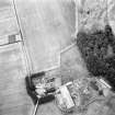
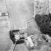
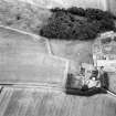
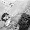
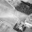
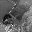
Aerial photography has recorded the cropmarks of a rectilinear enclosure 50m NE of Whitelaw farmsteading (NT57SE 68). It measures approximately 58m ENE-WSW by up to 42m transversely within a ditch 4m wide. The enclosure narrows towards the WSW end where it is roughly 30m wide and there are no apparent entrances. A number of indeterminate marks are visible within the enclosure. Until recent aerial photography (RCAHMSAP 1996) this site was interpreted only as a possible enclosure.
Information from RCAHMS (KB) 25 May 2000
Aerial Photographic Transcription (12 April 2002 - 22 April 2002)
An aerial transcription was produced from oblique aerial photographs. Information from Historic Environment Scotland (BM) 31 March 2017.
Note (22 January 2020)
The location, classification and period of this site have been reviewed.

