
West Mains


Geological Cropmark (Period Unknown), Ring Ditch (Prehistoric)
Site Name West Mains
Classification Geological Cropmark (Period Unknown), Ring Ditch (Prehistoric)
Canmore ID 56426
Site Number NT57SE 34
NGR NT 57377 72611
NGR Description Centre
Datum OSGB36 - NGR
Permalink http://canmore.org.uk/site/56426


- Council East Lothian
- Parish Whittingehame
- Former Region Lothian
- Former District East Lothian
- Former County East Lothian
NT57SE 34 NT 57501 72587
See also NT57SE 107
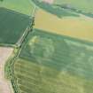
The cropmarks of two ring-ditches have been revealed by oblique aerial photographs, 200m NNW of West Mains farmsteading. The S of the two ring-ditches (NT c.5751 5258) is represented by a broad annular ditch with an internal diameter of about 15m to 18m. About 40m NNW is a further ring-ditch, approximately 8m to 10m across. Around and between these features are a number of linear cropmarks.
Information from RCAHMS (KJ) 19 May 1999.
Note (12 December 2019)
The location, classification and period of this site have been reviewed.
Aerial Photographic Transcription (28 February 2019)
An interpretative transcription, or mapping, of information on oblique aerial photographs was produced on 28 February 2019.
Aerial Photographic Transcription (28 February 2019)
An interpretative transcription, or mapping, of information on oblique aerial photographs was produced on 28 February 2019.
Sbc Note
Visibility: This is an upstanding earthwork or monument.
Information from Scottish Borders Council

