
West Mains


Enclosed Settlement (Iron Age)
Site Name West Mains
Classification Enclosed Settlement (Iron Age)
Canmore ID 56420
Site Number NT57SE 29
NGR NT 57108 72552
NGR Description Centre
Datum OSGB36 - NGR
Permalink http://canmore.org.uk/site/56420


- Council East Lothian
- Parish Whittingehame
- Former Region Lothian
- Former District East Lothian
- Former County East Lothian
NT57SE 29 NT 57101 72554
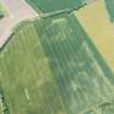
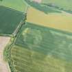
NT 572 726. Enclosure (Site), West Mains: An aerial photograph reveals, at about 400ft OD, part of a single-ditched enclosure, comprising two straight sides about 300ft long, meeting in a right angle. There is an apparent entrance-gap in the SE side. This is one of at least twenty rectilinear ditched enclosures in Mid- and East Lothian which are superficially comparable with the Iron Age timber-house sites of the Northumberland coastal plain.
G Maxwell 1970
This site falls at NT 5711 7254, on the slight NE slope of an arable field. There is no trace of any feature.
Visited by OS (RD) 26 March 1965
Further aerial photographs of this enclosure have been taken by the RCAHMS in 1976, 1977 and 1979.
(Undated) information in NMRS.
Scheduled as enclosure.
Information from Historic Scotland, scheduling order dated 23 May 1994.
Aerial Photographic Transcription (28 February 2019)
An interpretative transcription, or mapping, of information on oblique aerial photographs was produced on 28 February 2019.
Aerial Photographic Transcription (28 February 2019)
An interpretative transcription, or mapping, of information on oblique aerial photographs was produced on 28 February 2019.
Note (22 January 2020)
The location, classification and period of this site have been reviewed.

