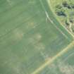
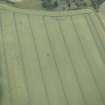
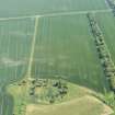
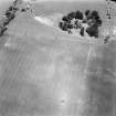
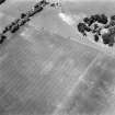
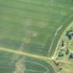
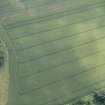
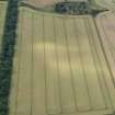
Accessibility

Font Size

100% 150% 200%

Background Colour

Default Contrast
Close Reset

Amisfield Mains

Ring Ditch House (Prehistoric)

Site Name Amisfield Mains

Classification Ring Ditch House (Prehistoric)

Canmore ID 56343

Site Number NT57NW 67

NGR NT 51621 75523

Datum OSGB36 - NGR

Permalink http://canmore.org.uk/site/56343

Ordnance Survey licence number AC0000807262. All rights reserved.
Canmore Disclaimer. © Bluesky International Limited 2025. Public Sector Viewing Terms

Toggle Aerial | View on large map

Digital Images

Oblique aerial view of the cropmarks of the ring ditch, looking NW.
Oblique aerial view of the cropmarks of the ring ditch, looking NW.Oblique aerial view of the location of the ring ditch under crop but with no visible cropmarking, looking N.Oblique aerial view of the cropmarks of the ring ditch, looking SSE.Oblique aerial viewOblique aerial viewOblique aerial view of the cropmarks of the ring ditch, looking SW.Amisfield Mains, NT57NW 67, Ordnance Survey index card, RectoOblique aerial view of the cropmarks of the ring ditch, looking E.Oblique aerial view of the site of the ring ditch, looking NNW.Oblique aerial view of the cropmarks of the ring ditch, looking ENE.Barley heads collected from outside the ring ditch (left) and inside the ring ditch (right)

Administrative Areas

  • Council East Lothian
  • Parish Haddington
  • Former Region Lothian
  • Former District East Lothian
  • Former County East Lothian

Activities

Aerial Photographic Transcription (14 March 2019)

An interpretative transcription, or mapping, of information on oblique aerial photographs was produced on 14 March 2019.

References

MyCanmore Image Contributions


Contribute an Image

MyCanmore Text Contributions