
Kaeheughs, Barney Mains


Pit Alignment(S) (Prehistoric)
Site Name Kaeheughs, Barney Mains
Classification Pit Alignment(S) (Prehistoric)
Alternative Name(s) Garleton Hills
Canmore ID 56329
Site Number NT57NW 54
NGR NT 51881 76041
NGR Description NT 5153 7606 to NT 5220 7633
Datum OSGB36 - NGR
Permalink http://canmore.org.uk/site/56329
Ordnance Survey licence number AC0000807262. All rights reserved.
Canmore Disclaimer.
© Bluesky International Limited 2025. Public Sector Viewing Terms
- Correction
- Favourite

SC 1250813
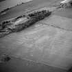
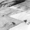
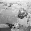
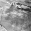
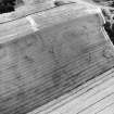
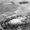
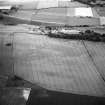
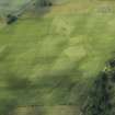
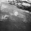
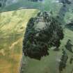
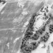
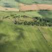
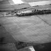
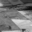
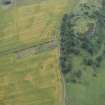
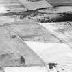
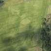
Kaeheughs, Barney Mains, oblique aerial view, taken from the SW, centred on the remains of a fort and on the cropmarks of an enclosure and pit-alignments.
RCAHMS Aerial Photography
2/7/1996
© Crown Copyright: HES

DP 216695
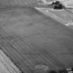
Oblique aerial view of the cropmarks of the pit-defined boundary system, looking ENE.
RCAHMS Aerial Photography Digital
9/7/2015
© Crown Copyright: HES

SC 1744195
Kaeheughs, Barney Mains, oblique aerial view, taken from the W, centred on the remains of a fort and on the cropmarks of an enclosure and pit-alignments.
RCAHMS Aerial Photography
2/7/1996
© Crown Copyright: HES

SC 1744582
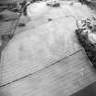
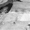
Oblique aerial view centred on the cropmarks of the pit-alignments with fort adjacent, taken from the SSW.
RCAHMS Aerial Photography
12/8/1999
© Crown Copyright: HES

SC 1744642
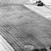
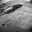
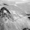
Kaeheughs, Barney Mains, fort and pit-alignments: oblique air photograph of cropmarks.
RCAHMS Aerial Photography
1979
© Crown Copyright: HES

SC 1744665
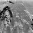
Kaeheughs, Barney Mains, fort, enclosure and pit-alignments: oblique air photograph of cropmarks.
RCAHMS Aerial Photography
1980
© Crown Copyright: HES

SC 2450913
Kaeheughs, Barney Mains, NT57NW 54, Ordnance Survey index card, page number 1, Recto
Records of the Ordnance Survey, Southampton, Hampshire, England
c. 1958
© Crown Copyright: HES (Ordnance Survey Archaeology Division)

SC 1250815
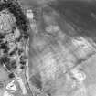
Oblique aerial view of Kaeheughs, Barney Mains, showing cropmarks of enclosure and pit-alignments
RCAHMS Aerial Photography
1990
© Crown Copyright: HES

SC 1744193
Kaeheughs, Barney Mains, oblique aerial view, taken from the ENE, centred on the remains of a fort and on the cropmarks of an enclosure and pit-alignments.
RCAHMS Aerial Photography
2/7/1996
© Crown Copyright: HES

SC 1744462
Oblique aerial view of Kaeheughs, Barney Mains, showing cropmarks of enclosure and pit-alignments
RCAHMS Aerial Photography
1990
© Crown Copyright: HES

SC 1744464
Kaeheughs, Barney Mains, enclosure and pit-alignments: oblique air photograph of cropmarks.
RCAHMS Aerial Photography
1990
© Crown Copyright: HES

SC 1744667
Kaeheughs, Barney Mains, fort, enclosure and pit-alignments: oblique air photograph of cropmarks.
RCAHMS Aerial Photography
1980
© Crown Copyright: HES

SC 1744668
Kaeheughs, Barney Mains, fort, enclosure and pit-alignments: oblique air photograph of cropmarks.
RCAHMS Aerial Photography
1980
© Crown Copyright: HES

SC 1744194
Kaeheughs, Barney Mains, oblique aerial view, taken from the NW, centred on the remains of a fort and on the cropmarks of an enclosure and pit-alignments.
RCAHMS Aerial Photography
2/7/1996
© Crown Copyright: HES

SC 1744198
Kaeheughs, Barney Mains, oblique aerial view, taken from the SE, centred on the remains of a fort and on the cropmarks of an enclosure and pit-alignments.
RCAHMS Aerial Photography
2/7/1996
© Crown Copyright: HES

SC 1744614
Oblique aerial view centred on the cropmarks of the pit-alignments with the remains of the fort adjacent, taken from the SSE.
RCAHMS Aerial Photography
21/11/2000
© Crown Copyright: HES

SC 1744626
Kaeheughs, Barney Mains, fort, enclosure and pit-alignments: oblique air photograph of cropmarks.
RCAHMS Aerial Photography
1977
© Crown Copyright: HES

SC 1928434
Kaeheughs, Barney Mains, fort, enclosure and pit-alignments: oblique air photograph of cropmarks.
Papers of Professor Dennis W Harding, archaeologist, Edinburgh, Scotland
1979
© Copyright: Professor Dennis W Harding. Courtesy of HES.

DP 216690
Oblique aerial view of the cropmarks of the enclosure and the pit-defined boundary system, looking WSW.
RCAHMS Aerial Photography Digital
9/7/2015
© Crown Copyright: HES

DP 216694
Oblique aerial view of the cropmarks of the pit-defined boundary system, looking ENE.
RCAHMS Aerial Photography Digital
9/7/2015
© Crown Copyright: HES

SC 1744196
Kaeheughs, Barney Mains, oblique aerial view, taken from the SW, centred on the remains of a fort and on the cropmarks of an enclosure and pit-alignments.
RCAHMS Aerial Photography
2/7/1996
© Crown Copyright: HES

SC 1744425
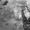
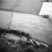
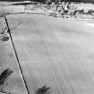
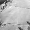
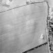
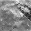
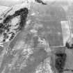
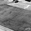
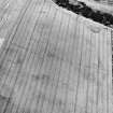
Kaeheughs, Barney Mains, pit-alignments: oblique air photograph of cropmarks.
RCAHMS Aerial Photography
1986
© Crown Copyright: HES

SC 1744611
Oblique aerial view centred on the cropmarks of the pit-alignments with the remains of the fort adjacent, taken from the SW.
RCAHMS Aerial Photography
21/11/2000
© Crown Copyright: HES

SC 1744664
Kaeheughs, Barney Mains, fort, enclosure and pit-alignments: oblique air photograph of cropmarks.
RCAHMS Aerial Photography
1980
© Crown Copyright: HES

SC 1744995
Kaeheughs, Barney Mains, pit-alignments: oblique air photograph of cropmarks.
RCAHMS Aerial Photography
1981
© Crown Copyright: HES

SC 1928433
Kaeheughs, Barney Mains, fort, enclosure and pit-alignments: oblique air photograph of cropmarks.
Papers of Professor Dennis W Harding, archaeologist, Edinburgh, Scotland
1979
© Copyright: Professor Dennis W Harding. Courtesy of HES.

SC 2013907
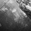
Oblique aerial view.
RCAHMS Aerial Photography
21/11/2000
© Crown Copyright: HES

SC 817870
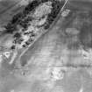
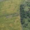
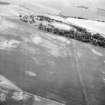
Oblique aerial view showing fort, enclosure and pit-alignments, Barney Mains, Kae Heugh.
RCAHMS Aerial Photography
1977
© Crown Copyright: HES

DP 216691
Oblique aerial view of the cropmarks of the pit-defined boundary system, looking SW.
RCAHMS Aerial Photography Digital
9/7/2015
© Crown Copyright: HES

DP 216693
Oblique aerial view of the cropmarks of the pit-defined boundary system, looking E.
RCAHMS Aerial Photography Digital
9/7/2015
© Crown Copyright: HES

DP 217556
Oblique aerial view of the cropmarks of the pit-defined boundary system and enclosure, looking WSW.
RCAHMS Aerial Photography Digital
22/7/2015
© Crown Copyright: HES

SC 1744427
Kaeheughs, Barney Mains, pit-alignments: oblique air photograph of cropmarks.
RCAHMS Aerial Photography
1986
© Crown Copyright: HES

SC 1744627
Kaeheughs, Barney Mains, fort, enclosure and pit-alignments: oblique air photograph of cropmarks.
RCAHMS Aerial Photography
1977
© Crown Copyright: HES

SC 1744663
Kaeheughs, Barney Mains, fort, enclosure and pit-alignments: oblique air photograph of cropmarks.
RCAHMS Aerial Photography
1980
© Crown Copyright: HES

SC 1744666
Kaeheughs, Barney Mains, fort, enclosure and pit-alignments: oblique air photograph of cropmarks.
RCAHMS Aerial Photography
1980
© Crown Copyright: HES

SC 1744993
Kaeheughs, Barney Mains, pit-alignments: oblique air photograph of cropmarks.
RCAHMS Aerial Photography
1981
© Crown Copyright: HES

SC 2450914
Kaeheughs, Barney Mains, NT57NW 54, Ordnance Survey index card, Recto
Records of the Ordnance Survey, Southampton, Hampshire, England
c. 1958
© Crown Copyright: HES (Ordnance Survey Archaeology Division)

DP 216696
Oblique aerial view of the cropmarks of the enclosure and pit-defined boundary system with the remains of the fort beyond, looking N.
RCAHMS Aerial Photography Digital
9/7/2015
© Crown Copyright: HES

SC 1744197
Kaeheughs, Barney Mains, oblique aerial view, taken from the SSE, centred on the remains of a fort and on the cropmarks of an enclosure and pit-alignments.
RCAHMS Aerial Photography
2/7/1996
© Crown Copyright: HES


SC 1744428
Kaeheughs, Barney Mains, pit-alignments: oblique air photograph of cropmarks.
RCAHMS Aerial Photography
1986
© Crown Copyright: HES

SC 1744461
Kaeheughs, Barney Mains, enclosure and pit-alignments: oblique air photograph of cropmarks.
RCAHMS Aerial Photography
1990
© Crown Copyright: HES

SC 1744581
Oblique aerial view centred on the cropmarks of the pit-alignments with fort adjacent, taken from the SW.
RCAHMS Aerial Photography
12/8/1999
© Crown Copyright: HES

SC 1744584
Oblique aerial view centred on the cropmarks of the pit-alignments with fort adjacent, taken from the S.
RCAHMS Aerial Photography
12/8/1999
© Crown Copyright: HES

SC 1744585
Oblique aerial view centred on the cropmarks of the pit-alignments with fort adjacent, taken from the ENE.
RCAHMS Aerial Photography
12/8/1999
© Crown Copyright: HES

SC 1744610
Oblique aerial view centred on the fort with pit-alignments adjacent, taken from the NNE.
RCAHMS Aerial Photography
21/11/2000
© Crown Copyright: HES

SC 1744994
Kaeheughs, Barney Mains, pit-alignments: oblique air photograph of cropmarks.
RCAHMS Aerial Photography
1981
© Crown Copyright: HES

SC 1928435
Kaeheughs, Barney Mains, fort, enclosure and pit-alignments: oblique air photograph of cropmarks.
Papers of Professor Dennis W Harding, archaeologist, Edinburgh, Scotland
1979
© Copyright: Professor Dennis W Harding. Courtesy of HES.

SC 1250816
Oblique aerial view centred on the cropmarks of the pit-alignments with fort adjacent, taken from the S.
RCAHMS Aerial Photography
12/8/1999
© Crown Copyright: HES

DP 217557
Oblique aerial view of the fort, and the cropmarks of the pit-defined boundary system and enclosure, looking WSW.
RCAHMS Aerial Photography Digital
22/7/2015
© Crown Copyright: HES

SC 1744426
Kaeheughs, Barney Mains, pit-alignments: oblique air photograph of cropmarks.
RCAHMS Aerial Photography
1986
© Crown Copyright: HES

SC 1744583
Oblique aerial view centred on the cropmarks of the pit-alignments with fort adjacent, taken from the S.
RCAHMS Aerial Photography
12/8/1999
© Crown Copyright: HES

SC 1744612
Oblique aerial view centred on the cropmarks of the pit-alignments with the remains of the fort adjacent, taken from the SW.
RCAHMS Aerial Photography
21/11/2000
© Crown Copyright: HES

SC 1744613
Oblique aerial view centred on the cropmarks of the pit-alignments with the remains of the fort adjacent, taken from the S.
RCAHMS Aerial Photography
21/11/2000
© Crown Copyright: HES

SC 1744615
Oblique aerial view centred on the cropmarks of the pit-alignments with the remains of the fort adjacent, taken from the SSE.
RCAHMS Aerial Photography
21/11/2000
© Crown Copyright: HES

SC 1744616
Oblique aerial view centred on the cropmarks of the pit-alignments with the remains of the fort adjacent, taken from the ESE.
RCAHMS Aerial Photography
21/11/2000
© Crown Copyright: HES

SC 1744685
Kaeheughs, Barney Mains, fort, enclosure and pit-alignments: oblique air photograph of cropmarks.
RCAHMS Aerial Photography
1980
© Crown Copyright: HES

DP 216689
Oblique aerial view of the cropmarks of the enclosure and the pit-defined boundary system, looking W.
RCAHMS Aerial Photography Digital
9/7/2015
© Crown Copyright: HES

DP 216692
Oblique aerial view of the cropmarks of the pit-defined boundary system, looking E.
RCAHMS Aerial Photography Digital
9/7/2015
© Crown Copyright: HES

SC 1744463
Kaeheughs, Barney Mains, enclosure and pit-alignments: oblique air photograph of cropmarks.
RCAHMS Aerial Photography
1990
© Crown Copyright: HES

SC 1744643
Kaeheughs, Barney Mains, fort and pit-alignments: oblique air photograph of cropmarks.
RCAHMS Aerial Photography
1979
© Crown Copyright: HES

SC 1744644
Kaeheughs, Barney Mains, fort and pit-alignments: oblique air photograph of cropmarks.
RCAHMS Aerial Photography
1979
© Crown Copyright: HES

SC 1744992
Kaeheughs, Barney Mains, pit-alignments: oblique air photograph of cropmarks.
RCAHMS Aerial Photography
1981
© Crown Copyright: HES


- Council East Lothian
- Parish Haddington
- Former Region Lothian
- Former District East Lothian
- Former County East Lothian
NT57NW 54 5153 7606 to 5220 7633
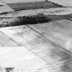
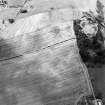
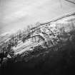
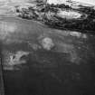
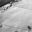
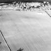
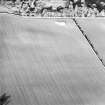
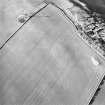
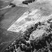
NT 515 760 to NT 521 763. Proximity is no evidence of association, but air photographs reveal pit-alignments on the Garleton Hills that appear to divide up the area immediately around the fort on the summit (NT57NW 23) into large parcels of land.
H Welfare 1980
Additional aerial photographs taken in 1980.
(Undated) information in NMRS.
Scheduled (with NT57NW 57) as Barney Mains, pit alignments.
Information from Historic Scotland, scheduling document dated 10 June 1994.

