
Pricing Change
New pricing for orders of material from this site will come into place shortly. Charges for supply of digital images, digitisation on demand, prints and licensing will be altered.
Dalvreck


Pit Alignment (Prehistoric)
Site Name Dalvreck
Classification Pit Alignment (Prehistoric)
Canmore ID 56320
Site Number NT57NW 46
NGR NT 51060 77960
NGR Description NT 51017 77945 to NT 51076 77972
Datum OSGB36 - NGR
Permalink http://canmore.org.uk/site/56320


- Council East Lothian
- Parish Athelstaneford
- Former Region Lothian
- Former District East Lothian
- Former County East Lothian
Note (27 September 2022)
The location, classification and period of this site have been reviewed.
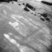
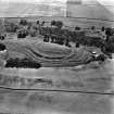
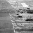
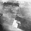
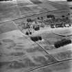
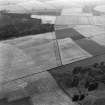
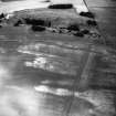
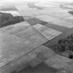
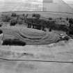
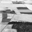
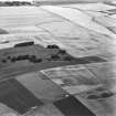
Aerial Photographic Interpretation (27 September 2022)
This pit alignment has been recorded as cropmarking on oblique photographs (RCAHMSAP 1979, 1980, 1983, 1988) on the NE facing of Kilduff Hill. It extends from the ENE to WSW for about 65m. The pits are elongated and set about 1-2m apart. It is intersected by second, perpendicular, pit alignment (NT57NW 50).
Information from HES Archaeological Survey (F. Vermeij) 27 September 2022

