
Dalvreck


Palisaded Enclosure (Later Prehistoric)
Site Name Dalvreck
Classification Palisaded Enclosure (Later Prehistoric)
Canmore ID 56317
Site Number NT57NW 43
NGR NT 50488 78335
Datum OSGB36 - NGR
Permalink http://canmore.org.uk/site/56317


- Council East Lothian
- Parish Athelstaneford
- Former Region Lothian
- Former District East Lothian
- Former County East Lothian
Note (27 September 2022)
The location, classification and period of this site have been reviewed.
Aerial Photographic Interpretation (27 September 2022)
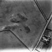
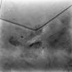
This later prehistoric palisaded enclosure has been recorded as cropmarking on oblique aerial photographs (RCAHMSAP 1978) on a gentle NW facing slope 160m SW of The Chesters fort (NT57NW 1). It measures about 41m in diameter within a narrow palisade trench about 0.5-1.5m broad, broken by a possible entrance on the SW. The N section of the enclosure has not been recorded. It is unclear if this is a real gap or due to differential cropmark formation. Pit alignments, probably presenting prehistoric land divisions, have been recorded around 45m to the E (NT57NW 51), while two later prehistoric settlements have been recorded around 150m to the W (NT57NW 30) and 180m to the NE (NT57NW 41) respectively.
Information from HES Archaeological Survey (F. Vermeij) 27 September 2022

