 |
On-line Digital Images |
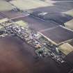
SC 968456 |
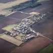
RCAHMS Aerial Photography |
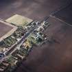
General oblique aerial view centred on the village with the building and farmsteading adjacent, taken from the W. |
17/2/2005 |
Item Level |
|
 |
On-line Digital Images |
SC 1644309 |
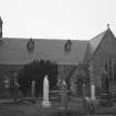
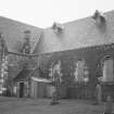
List C Survey |
View from S. |
1975 |
Item Level |
|
 |
On-line Digital Images |
SC 1644310 |
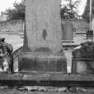
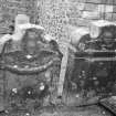
List C Survey |
View of monuments in churchyard. |
1975 |
Item Level |
|
 |
On-line Digital Images |
SC 1644311 |
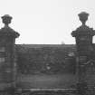
List C Survey |
View of burial enclosure in churchyard. |
1975 |
Item Level |
|
 |
On-line Digital Images |
SC 1644313 |
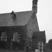
List C Survey |
General view of W end from N. |
1975 |
Item Level |
|
 |
On-line Digital Images |
SC 1644314 |
List C Survey |
View from NW. |
1975 |
Item Level |
|
 |
On-line Digital Images |
SC 1644315 |
List C Survey |
View of headstone of 1721. |
1975 |
Item Level |
|
 |
On-line Digital Images |
SC 1644316 |
List C Survey |
View of two eighteenth century headstones. |
1975 |
Item Level |
|
 |
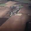
On-line Digital Images |
SC 1680188 |
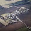
RCAHMS Aerial Photography |
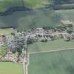
General oblique aerial view centred on the village, taken from the NE. |
17/2/2005 |
Item Level |
|
 |
On-line Digital Images |
SC 1680189 |
RCAHMS Aerial Photography |
General oblique aerial view centred on the village, taken from the NE. |
17/2/2005 |
Item Level |
|
 |
On-line Digital Images |
SC 1680190 |
RCAHMS Aerial Photography |
General oblique aerial view centred on the village with the building and farmsteading adjacent, taken from the NW. |
17/2/2005 |
Item Level |
|
 |
On-line Digital Images |
SC 1680191 |
RCAHMS Aerial Photography |
General oblique aerial view centred on the village with the building and farmsteading adjacent, taken from the WNW. |
17/2/2005 |
Item Level |
|
 |
On-line Digital Images |
SC 1680192 |
RCAHMS Aerial Photography |
General oblique aerial view centred on the village with the building and farmsteading adjacent, taken from the W. |
17/2/2005 |
Item Level |
|
 |
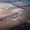
On-line Digital Images |
SC 1680193 |
RCAHMS Aerial Photography |
General oblique aerial view centred on the village, taken from the WSW. |
17/2/2005 |
Item Level |
|
 |
On-line Digital Images |
SC 1680194 |
RCAHMS Aerial Photography |
General oblique aerial view looking across the village towards the airfield and museum, taken from the SW. |
17/2/2005 |
Item Level |
|
 |
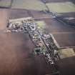
On-line Digital Images |
SC 1680195 |
RCAHMS Aerial Photography |
Oblique aerial view of the village centred on the church, burial-ground and burial-enclosure, taken from the NE. |
17/2/2005 |
Item Level |
|
 |
On-line Digital Images |
SC 1680196 |
RCAHMS Aerial Photography |
Oblique aerial view of the village centred on the church, burial-ground and burial-enclosure, taken from the NW. |
17/2/2005 |
Item Level |
|
 |
On-line Digital Images |
DP 391555 |
Historic Environment Scotland |
Oblique aerial view. |
23/6/2022 |
Item Level |
|
 |
On-line Digital Images |
SC 2450834 |
Records of the Ordnance Survey, Southampton, Hampshire, England |
Athelstaneford, Main Street, Parish Church And War Memorial, NT57NW 2, Ordnance Survey index card, page number 1, Recto |
c. 1958 |
Item Level |
|


