
Pricing Change
New pricing for orders of material from this site will come into place shortly. Charges for supply of digital images, digitisation on demand, prints and licensing will be altered.
Drylawhill


Cropmark(S) (Period Unknown)
Site Name Drylawhill
Classification Cropmark(S) (Period Unknown)
Alternative Name(s) Prestonkirk Parish Church
Canmore ID 56271
Site Number NT57NE 68
NGR NT 59010 78020
Datum OSGB36 - NGR
Permalink http://canmore.org.uk/site/56271


- Council East Lothian
- Parish Prestonkirk
- Former Region Lothian
- Former District East Lothian
- Former County East Lothian
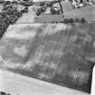
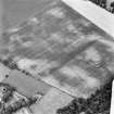
NT57NE 68 5901 7802.
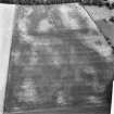
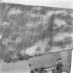
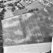
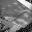
There is a cropmark situated at NT 5901 7801 in the field to the N of Prestonkirk Parish Church. It consists of two semi-circular lines facing each other with a gap in the W arc. There are a further two cropmarks, c65m to the ESE and c160m to the SE at NT 5909 7798 and 5911 7787.
RCAHMSAP (RHM) 1 Sept 1993.
Aerial Photographic Transcription (12 August 1993)
An aerial transcription was produced from oblique aerial photographs. Information from Historic Environment Scotland (BM) 31 March 2017.
Desk Based Assessment (8 February 2002)
Headland Archaeology undertook an assessment of archaeological issues affecting a proposed area of development at Drylawhill, East Linton.
This 24 ha site on the north side of the village has been identified by East Lothian Council as a potential site for approximately 350 houses.
None of the archaeological features have been subject to field evaluation so the level of knowledge about specific features is low. However, the majority of the development site lies within the limits of a scheduled ancient monument and therefore the archaeological features are, de facto, of national importance.
Headland Archaeology 2002

