
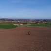
Pencraig Hill


Standing Stone (Prehistoric)
Site Name Pencraig Hill
Classification Standing Stone (Prehistoric)
Canmore ID 56240
Site Number NT57NE 4
NGR NT 5810 7681
Datum OSGB36 - NGR
Permalink http://canmore.org.uk/site/56240


- Council East Lothian
- Parish Prestonkirk
- Former Region Lothian
- Former District East Lothian
- Former County East Lothian
NT57NE 4 5810 7681.
(NT 5810 7681) Standing Stone (NR)
OS 6" map (1968)
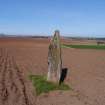
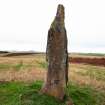
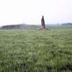
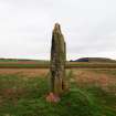
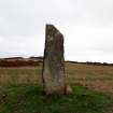
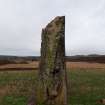
Standing Stone, Pencraig Hill: This three-sided pillar is 10ft high and the sides measure about 3ft in breadth just above ground level. Its top is pointed.
R W Feachem 1963; RCAHMS 1924, visited 1913
As described. It bears no marks or inscriptions.
Resurveyed at 1:2500.
Visited by OS (WDJ) 24 October 1962
Field Visit (4 June 1913)
Some 55 yards north of the Haddington and East Linton road, on Pencraig Hill, about ¾ mile west of East Linton is a fine standing stone roughly triangular in section and pointed at the top. It measures 10 feet in height and 9 feet 3 inches in girth at the base.
RCAHMS 1924, visited 4 June 1913.

