
Pricing Change
New pricing for orders of material from this site will come into place shortly. Charges for supply of digital images, digitisation on demand, prints and licensing will be altered.
Dabshead


Commemorative Stone (19th Century) - (20th Century), Standing Stone (Period Unassigned), Standing Stone (Prehistoric)
Site Name Dabshead
Classification Commemorative Stone (19th Century) - (20th Century), Standing Stone (Period Unassigned), Standing Stone (Prehistoric)
Canmore ID 56039
Site Number NT55SW 22
NGR NT 54710 51240
Datum OSGB36 - NGR
Permalink http://canmore.org.uk/site/56039


- Council Scottish Borders, The
- Parish Lauder
- Former Region Borders
- Former District Ettrick And Lauderdale
- Former County Berwickshire
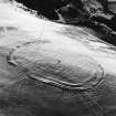
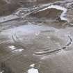
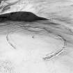
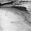
NT55SW 22 5471 5124.
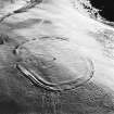
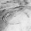
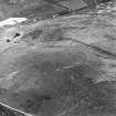
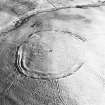
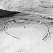
In the centre of the fort noted on NT55SW 14 is a monolithic stone; this is not an antiquity, but was erected on the marriage of the present Countess of Meath.
R Romanes 1897
NT 547 513. This stone, on the summit of the hill, measures 12' x 3 1/2' x 1 1/2'. There are at least seven cups on W and four on E faces, up tp 7" in diameter and 2" deep. It is possible that the cup marks were on the stone before it was re-used as a monument in the 19th century. (Information from R W B Morris letter 12 December 1968).
R W B Morris 1969
This stone is a memorial and contains five cup marks, three on the NE and two on the SW.
Visited by OS (SFS) 7 August 1975
This stone was moved from the moorland somewhere a little N of circles (on Borrowston Rig - see NT55SE 19).
W M'Conachie 1913
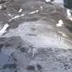
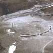
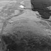
NT 5471 5124. This standing stone, which is now leaning and is in imminent danger of collapse, is 3.5m high, 1.0m wide and 0.4m thick. It is supported at the base by a substanttial modern cairn which is 3.0m in diameter and 1.0m high. There are five large cup marks on the stone and several other depressions near the top of its south-west side. The origin and date of these marks cannot be ascertained.
Surveyed at 1/10,000.
Visited by OS (BS) 15 May 1979
Note (6 August 2020)
Date Fieldwork Started: 06/08/2020
Compiled by: ELF
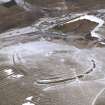
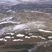
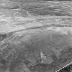
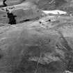
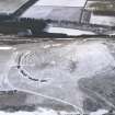
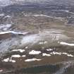
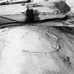
Location Notes: The sandstone standing stone is situated prominently In the centre of the prehistoric fort of Dabshead (Canmore ID 56030) at an altitude of 383m. It had previously been held upright by a cairn of around 50 stones and iron bars, but has now substantially subsided and is leaning at angle of 32 degrees pointing to the NE. The stone lies 7m NW of the Ordnance Survey Trig point number BM S7405. The area within the fort is rough grazing and Dabshead Hill, on which the standing stone is situated, is general heather and grass moorland.
Panel Notes: The length of the stone above ground level is 3.72m with a width of 0.8m and a breadth of 0.5m. Canmore notes several cupmarks on the stone but close inspectionin the field and on the 3D model indicates that these are geological anomalies. There are three circular hollow depressions on the NE face, the largest of which is 0.14 x 0.10m and smallest 0.11 x 0.11m, and three smaller depressions on the SW face, each measuring about 0.02m, These features all appear to be natural weathering or geological anomalies, which are characteristic of the stone in this area. The stone has a number of carved modern initials on the surface.
Sbc Note
Visibility: This is an upstanding earthwork or monument.
Information from Scottish Borders Council

