
Carfrae Bastle


Bastle (Medieval)
Site Name Carfrae Bastle
Classification Bastle (Medieval)
Canmore ID 55999
Site Number NT55NW 9
NGR NT 50182 55078
Datum OSGB36 - NGR
Permalink http://canmore.org.uk/site/55999


- Council Scottish Borders, The
- Parish Channelkirk
- Former Region Borders
- Former District Ettrick And Lauderdale
- Former County Berwickshire
NT55NW 9 50182 55078
(NT 5018 5507) Peel (NR) (Remains of)
OS 6" map (1957)
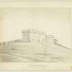
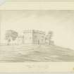
The remains of a peel (A Allan 1900) or bastle, standing to first floor height and having a round stair turret in the SE angle are close to the present farmhouse at Carfrae.
RCAHMS 1915, visited 1908
The overgrown remains, standing to first floor height, are of rubble masonry and measure 10.5m x 5.5m. They are divided into two compartments. The stair tower is 4.0m in diameter.
Visited by OS (JD) 15 February 1955 and (SFS) 11 August 1975
Field Visit (17 October 1908)
25. Bastel House, Carfrae.
At the end of the garden adjoining the farm-house of Carfrae are the ruined remains of a bastel house still standing as high as the first floor. It has a round tower, which has contained the staircase, in the south-east corner. Access to this has been by a doorway from the east of the two vaulted apartments in the basement. Length of frontage, 35 feet; of east wall, including diameter of tower (18 feet), 29 feet 6 inches.
See History of Channelkirk, p.654.
RCAHMS 1915, visited 17 October 1908.
OS Map: Ber., xiii. NE (unnoted).
Sbc Note
Visibility: Upstanding building, which may not be intact.
Information from Scottish Borders Council

