
Lauder, East High Street, St Mary's Parish Church


Burial Ground (Period Unassigned), Church (17th Century), War Memorial(S) (20th Century)
Site Name Lauder, East High Street, St Mary's Parish Church
Classification Burial Ground (Period Unassigned), Church (17th Century), War Memorial(S) (20th Century)
Alternative Name(s) Lauder Kirk; Lauder Parish Church, Including Entrance Gates And Churchyard Wall: War Memorial Plaques; Maj J Elliot War Memorial Plaque
Canmore ID 55875
Site Number NT54NW 47
NGR NT 53093 47533
Datum OSGB36 - NGR
Permalink http://canmore.org.uk/site/55875


First 100 images shown. See the Collections panel (below) for a link to all digital images.
- Council Scottish Borders, The
- Parish Lauder
- Former Region Borders
- Former District Ettrick And Lauderdale
- Former County Berwickshire
NT54NW 47.00 53093 47533 Church
NT54NW 47.01 centred on 5308 4751 Burial-ground
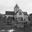
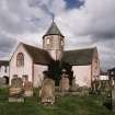
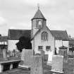
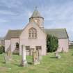
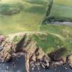
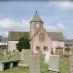
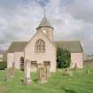
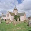
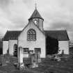
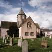
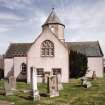
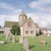
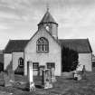
(NT 5309 4752) St Mary's Church: dated 1673, Sir William Bruce, architect (replacing the church noted on NT54NW 6) repaired 1820 and 1864. Cruciform in plan with four equal arms; crossing surmounted by four pointed arches which carry a central tower, square to the height of the roof ridges, thereafter rising octagonally and finished with a slate roof.
Walled graveyard and gateway with rusticated piers (also Listed: A).
D MacGibbon and T Ross 1897; RCAHMS 1915, visited 1908; G Hay 1957.
NMRS REFERENCE:
Architect: Sir William Bruce, 1673
Field Visit (12 August 1908)
207. Lauder Church.
This church is cruciform in plan, with four equal arms extending from a central crossing 14 feet square; internally each arm is 28 feet 6 inches in length by 16 feet in width. The crossing is surmounted by four pointed arches which carry a central tower, square to the height of the roof ridges, thereafter rising octagonally, and finished with a slated roof. The date 1673 on the north gable is that of the building. Its erection was due to the Duke of Lauderdale, who had as architect Sir W. Bruce, Superintendent of the Works at Holyrood. It was repaired in 1822 and 1864.
See Eccles. Arch., iii. p. 582 (plan and illus.); The King's Master Masons, p. 185.
RCAHMS 1915, visited 12th August 1908.
OS Map: Ber., xix. NE.
Publication Account (1980)
The church, said to have been built in a cruciform shape, appeared on Bleau 's map of 1654, but identification of the actual site today is rather tenuous as the kirkyard was also moved. The plan of the new parish church (which was built to the west of the tolbooth) is a unique design of Sir William Bruce, who at that time was engaged in work on Thirestane Castle. It is in the shape of a Greek Cross with all four arms of the cross of equal length extending from a central crossing. The crossing is surmounted by four pointed arches, which carry the 'handsome little steeple' ordered by The Earl of Lauderdale, who largely funded the rebuilding (RCAM, 1909, 36; Hay, 1957, 66).
Information from ‘Historic Lauder: The Archaeological Implications of Development’ (1980).
Publication Account (1985)
Lauder's parish church displays a most unusual form. Neither T-shaped nor rectangular, it is centrally planned-a Greek cross with four equal arms spreading from a central crossing, above which four pointed arches carry the central tower. Square to the length of the roof-ridge, this tower thereafter is octagonal. In the centre of the church, beneath the tower, stands the pulpit
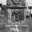
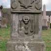
The north gable is dated 1673, when it was built by Sir William Bruce for the Duke of Lauderdale who simply requested that it be "decent and large enough, with a handsom litle steeple". It has a strong vernacular character, and though repaired in 1822 and again in 1864, remains one of the best-preserved centrally planned churches in Scotland. When built, at least two of the arms contained lofts; and there was an altar in the eastern arm. The ruined watch-house in the churchyard is considerably younger, however, built after a body-snatching raid in 1830.
A few kilometres north of Laud er, just west of the A G8 and astride the line of the Roman road, lies the church at Channelkirk (NT 481545)-a light and airy building in a perpendicular Gothic style. Rectangular in shape, and with an attractive acanthus-ornamented belfrey, its "chief eyesore is the architectural tumour.... which the inside stair leading to the gallery has swollen outwards for its own relief'! It was built in 1841, along with manse and garden, to replace an earlier church. The burial ground contains a number of interesting earlier stones, including two from the second/third quarter of the 18th century displaying somewhat roughly sculpted but remarkably detailed figure carvings.
Information from 'Exploring Scotland's Heritage: Lothian and Borders', (1985).
Sbc Note (15 April 2016)
Visibility: Standing structure or monument.
Information from Scottish Borders Council

