
Pricing Change
New pricing for orders of material from this site will come into place shortly. Charges for supply of digital images, digitisation on demand, prints and licensing will be altered.
Bemersyde House


Armorial Panel (16th Century), Country House (Period Unassigned), Tower House (Medieval), War Memorial (20th Century)
Site Name Bemersyde House
Classification Armorial Panel (16th Century), Country House (Period Unassigned), Tower House (Medieval), War Memorial (20th Century)
Alternative Name(s) Bemerside; Bemersyde Tower; Bemersyde Castle; Earl Haig War Memorial
Canmore ID 55703
Site Number NT53SE 9
NGR NT 59216 33328
Datum OSGB36 - NGR
Permalink http://canmore.org.uk/site/55703


![Scanned image of IGL W421/18/1 [negative number to be supplied].](http://i.rcahms.gov.uk/canmore/l/SC00840991.jpg)


![Scanned image of IGL W421/18/1 [negative number to be supplied].](http://i.rcahms.gov.uk/canmore/s/SC00840991.jpg)


- Council Scottish Borders, The
- Parish Mertoun
- Former Region Borders
- Former District Ettrick And Lauderdale
- Former County Berwickshire
NT53SE 9.00 59216 33328
NT53SE 9.01 5930 3330 Gardens
NT53SE 9.02 5927 3338 Building
NT53SE 9.03 5920 3340 Kitchen Garden
NT53SE 63 59240 33308 Sundial
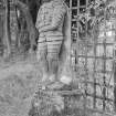
For Wallace's Statue see NT53SE 103
(NT 5922 3334) Bemersyde House (NR)
OS 6" map (1967)
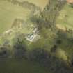
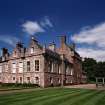
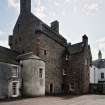
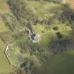
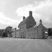
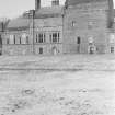
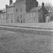
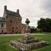
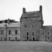
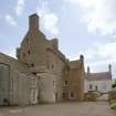
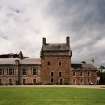
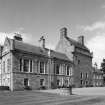
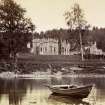
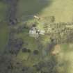
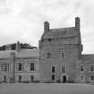
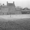
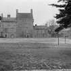
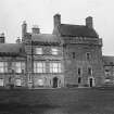
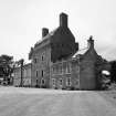
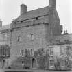
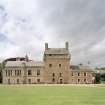
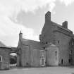
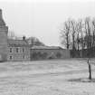
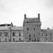
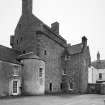
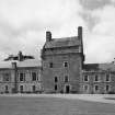
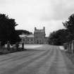
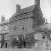
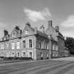
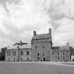
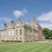
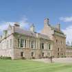
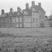
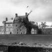
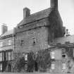
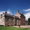
Bemersyde consists of a lofty rectangular tower, to which lower, modern extensions have been added to W and E. The original building, which has been a fairly typical Border peel-tower, rises to five storeys and dates from the early 16th century; it was probably built in conformity with the Act of the Scots Parliament of 1535 'for bigging of strengthis on the Bordouris'.
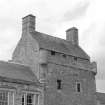
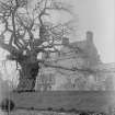
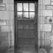
The upper storey is a 17th century reconstruction. The walls are very massive, reaching a thickness of 10 ft. The main doorway is in the S front, and has been enlarged. Undoubtedly there would be a house on this site from very early times, for the Haigs of Bemersyde are a very ancient family, having owned the lands reputedly as early as the 12th century, and the present building may well incorporate portions of an earlier house in its foundations.
N Tranter 1962; RCAHMS 1915, visited 1912
As described above.
Visited by OS (JD) 26 May 1955.
NMRS REFERENCE:
Architect: James Pearson Allison - remodelling of 16th and 17th century tower
Ian G Lindsay - reconstruction - 1961
Owner: Earl Haig
Field Visit (15 April 1912)
261. Bemersyde.
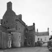
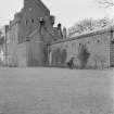
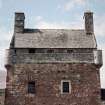
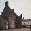
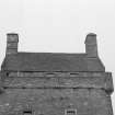
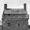
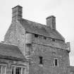
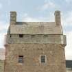
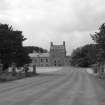
This tower (fig. 142 [SC 1172954]) is situated on the east bank of the Tweed some 1 ½ miles by road to the north of St Boswells. The old building is now flanked on the east and west by extensive modern additions. It consists of a rectangular keep (fig. 143) measuring some 20 feet by 16 feet 6 inches within walls varying from 6 feet to 10 feet 6 inches in thickness, and 40 feet in height from the ground to the top of the parapet. The ground floor has been almost completely modernised, but the existing doorway in the south wall seems to indicate the original position of the main entrance. Within the south-east angle a doorway communicates with the wheel-stair which gives direct access to three upper floors, whence a modern wooden staircase leads to the reconstructed attics. Immediately above the ground-floor level there is a vaulted mezzanine floor measuring some 24 feet by 16 feet 6 inches, having two deeply recessed windows in the south wall and two recently formed doorways in the east and west walls which give access to the wings of the modern house. Next in order comes the great hall on the first floor having a wall chamber formed at the north-east angle with access from a central passage which has been originally lighted by a small window to the exterior and which has a stone bench on the north in-go. The wall chamber is lighted by a small window in the north wall, and it has a fireplace in the east wall and an ambry in the west wall. A doorway on the south side of the central passage opens into a small recess or cupboard formed in the thickness of the wall. The hall is lighted by a single window (having a stone bench) in the north wall, and by two narrow openings which pierce the south wall. The westmost of these two windows has an ambry formed in the west jamb with a wooden door hung on wrought-iron hinges of good design and having an ornamental lock-plate of similar character and material (fig. 143). At the level of the third floor access is gained to the parapet walks on the north and south sides of the tower, terminating at the angles in round corbelled turrets which communicate with each other from within the building. The construction of this floor and of the attics shows signs of considerable alterations at a late date, when they were apparently heightened and the crow-stepped gables, with their huge chimney-stacks, were built to suit the altered conditions. The upper member of the parapet and of the angle turrets is ornamented with a cable-moulding, and on the north and south elevations seven gargoyles, each of a different design, project at regular intervals from the level of the corbel-table. The corbelled projections of the angle-turrets are enriched with a curious succession of hollows cut on the upper members, indicating a date similar to that of the table ornament. The present means of access to the angle-turrets and to the parapet walks is evidently the result of this reconstruction.
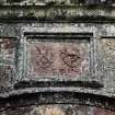
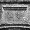
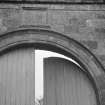
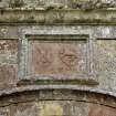
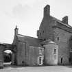
Heraldic Panel.
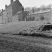
Over the arch of the modern gateway to the east of the castle is a panel containing two shields bearing arms: Dexter, A saltire between two stars in chief and base and two crescents in flanks; Sinister, A lion rampant crowned. Carved below the shields respectively are the initials A· H and E. M and the date 1581. The contents of the panel have been re-cut. The arms and initials are those of Andrew Haig, who owned Bemersyde at the date given, and those of his third wife, Elizabeth Macdougall.
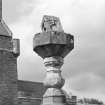
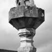
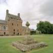
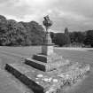
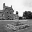
Sun-dial.
On the lawn to the south of the castle is a sun-dial of Renaissance design. The dial has a sloping stone gnomon and is octagonal on plan. It is supported by a moulded baluster resting on a modernised pedestal and approached by three broad steps. The dial face measures 1 foot 8 ½ inches between the parallel sides, and the height from the top of the steps to the point of the gnomon is fully 7 feet. Carved in relief on the northern side of the dial face is a shield bearing the Haig arms with helmet and mantling, and on the eastern margin of the sloping gnomon BEMERSYDE 1691 is also cut in relief. The section of the dial stone is such that sixteen surfaces are developed on the sides, each one bearing a small dial of conventional design.
See Cast. and Dom. Arch., iii. p. 220, and v. p. 234 (illus.); The Haigs of Bemersyde, p. 4 (illus.).
RCAHMS 1915, visited 15th April 1912.
OS Map: Ber., xxx. SW. and SE.
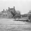
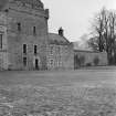
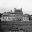
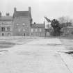
Photographic Survey (January 1961)
Photographic survey of the garden and exterior of Bemersyde House, Berwickshire, by the Scottish National Buildings Record in January 1961.
Sbc Note
Visibility: This is an upstanding building.
Information from Scottish Borders Council.

