
Earlston, Rhymer's Tower


Tower (16th Century)
Site Name Earlston, Rhymer's Tower
Classification Tower (16th Century)
Canmore ID 55512
Site Number NT53NE 3
NGR NT 57205 38250
Datum OSGB36 - NGR
Permalink http://canmore.org.uk/site/55512


- Council Scottish Borders, The
- Parish Earlston
- Former Region Borders
- Former District Ettrick And Lauderdale
- Former County Berwickshire
NT53NE 3.00 57205 38250
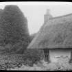
NT53NE 3.01 NT 5721 3824 Cottage
(NT 5720 3824) Tower (NR) (rems of)
OS 6" map (1967)
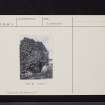
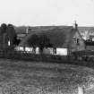
Rhymer's Tower: The ruins of the tower or castle of Thomas the Rhymer stand near the W end of Earlston village. Part of the W and N walls still stand. A small thatched cottage occupies part of the site.
Name Book 1857
The SW wall, standing to a height of about 20 ft, and part of the W wall of this small keep remain. It was originally rectangular on plan, with a frontage of 23 ft and walls 4 ft thick. The lower chamber has been vaulted. Though this tower is traditionally said to have been the residence of Thomas the Rhymer, otherwise Thomas of Ercildoune (13th century), it is of much later date.
RCAHMS 1915, visited 1908
The remains of this typical 16th century border peel are as described by the RCAHMS. The SW and W walls measure 7.1 m and 2.9 m long respectively and vary between 5.0 m and 0.7 m in height.
Visited by OS (JD) 19 May 1955
NT 571 382 A watching brief was undertaken by Scotia Archaeology Ltd during the machine excavation of trenches prior to the proposed construction of an extension to a restaurant/cafe, some 7m SE of the ruined tower house. Removal of 0.5m of topsoil from an area measuring 14m E-W by 3.5-5.5m wide, and the excavation of test pits along the lines of the proposed wall foundations did not reveal any features or deposits contemporary with the occupation of the tower. The only structure to be uncovered was the fragmentary rubble wall foundation of a 19th-century cottage.
Sponsor: J McKee
A Barlow 1996
Field Visit (14 August 1908)
129. Rhymer’s Tower, Earlston.
At the south-west end of the town of Earlston, and about 100 yards north of the road bridge over the Leader, is the ivy-covered ruin of a small keep, consisting of the south-west wall to a height of about 20 feet and a portion of the west wall. It has been rectangular in plan, with a frontage of 23 feet and walls 4 feet thick. The lower chamber has been vaulted, and about 5 feet from the present ground-level corbels project for support of an entresol. About 8 feet up on the south-west wall a small square window pierces the vaulting.
The tower is traditionally said to have been the residence of Thomas the Rhymer, otherwise Thomas of Ercildoune, the early Scottish poet, who flourished in the 13th century, but this early date cannot be maintained for the present edifice. The tower has been acquired by the Edinburgh Border Counties Association.
RCAHMS 1915, visited 14th August 1908.
OS Map: Ber., xxvi. S.W.
Photographic Survey (1961)
Photographic survey by the Scottish National Buildings Record in 1961.
Sbc Note
Visibility: Upstanding building, which may not be intact.
Information from Scottish Borders Council

