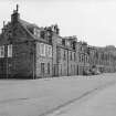
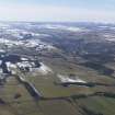
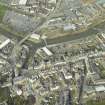
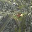
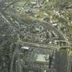
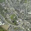
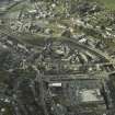
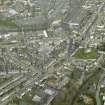
Accessibility

Font Size

100% 150% 200%

Background Colour

Default Contrast
Close Reset

Hawick, General

Burgh (16th Century), Town (Period Unassigned)

Site Name Hawick, General

Classification Burgh (16th Century), Town (Period Unassigned)

Canmore ID 55362

Site Number NT51SW 34

NGR NT 50321 14628

NGR Description Centred on NT 50321 14628

Datum OSGB36 - NGR

Permalink http://canmore.org.uk/site/55362

Ordnance Survey licence number AC0000807262. All rights reserved.
Canmore Disclaimer. © Bluesky International Limited 2025. Public Sector Viewing Terms

Toggle Aerial | View on large map

Digital Images

Hawick, terraced houses
General view taken from corner of Arthur Street and Earl Street, looking NNW
Hawick, terraced houses
General view taken from corner of Arthur Street and Earl Street, looking NNWOblique aerial view centred on the North Bridge area, taken from the SSW.Oblique aerial view centred on the High Street, taken from the SE.Oblique aerial view centred on the High Street, taken from the NE.Oblique aerial view centred on the High Street, taken from the SE.General oblique aerial view with Hawick in the distance, looking WSW.Hawick, General, NT51SW 34, Ordnance Survey index card, RectoGeneral oblique aerial view centred on town, taken from the NE.Oblique aerial view centred on Glebe Mills, taken from the NNE.Oblique aerial view centred on the High Street, taken from the SE.General oblique aerial view of Hawick with the Eildon Hills in the distance, looking NNE.Oblique aerial view of Wellogate Farm, Hawick, looking SE.Oblique aerial view of Hawick, looking NE.Oblique aerial view.Oblique aerial view centred on Drumlanrig Bridge, taken from the S.General oblique aerial view centred on town, taken from the NE.General oblique aerial view centred on town, taken from the NE.Oblique aerial view centred on the High Street, taken from the SW.Oblique aerial view of Hawick, looking SE.Copy of historic photograph showing view of Burgh Arms Public House.Oblique aerial view centred on Glebe Mills, taken from the N.Oblique aerial view centred on the Wilton area, taken from the SW.Oblique aerial view centred on the High Street, taken from the SE.General oblique aerial view centred on the town , taken from the SW.Oblique aerial view of Hawick, looking ENE.General oblique aerial view centred on the central area of the town , taken from the SW.Oblique aerial view centred on the central area of the town, the new leisure Centre on the site of the railway station and the bridges over the River Teviot, taken from the NE.Oblique aerial view centred on High Street, taken from the W.Hawick, general view, showing Teviot Road and Commercial Road.  Oblique aerial photograph taken facing east.Oblique aerial view of Hawick centred on Stonefield Place, looking E.Oblique aerial view of Hawick, looking ENE.Hawick, 16-19 Mansfield Road
View across river to terraced houses and public houseOblique aerial view centred on the central area of the town on the S bank of the River Teviot, taken from the ENE.Oblique aerial view centred on Drumlanrig Bridge and St Mary's Church, taken from the NE.General view of Old Mortality's Cottage.Oblique aerial view centred on the High Street, taken from the SE.Oblique aerial view of Wellogate Farm, Hawick, looking SE.Oblique aerial view of Hawick centred on Stonefield Place, looking E.General oblique aerial view centred on the central area of the town, taken from the E.Oblique aerial view centred on Drumlanrig Bridge and former site of railway station, taken from the SW.Oblique aerial view centred on the High Street, taken from the NE.Oblique aerial view centred on High Street, taken from the SSW.General oblique aerial view centred on town, taken from the SW.Oblique aerial view centred on Drumlanrig Bridge and St Mary's Church, taken from the SW.Oblique aerial view centred on the centrel area, taken from the SW.

Administrative Areas

  • Council Scottish Borders, The
  • Parish Hawick
  • Former Region Borders
  • Former District Roxburgh
  • Former County Roxburghshire

Archaeology Notes

NT51SW 34 Centred on 50449 14879

SBS Hawick 1980

Erected burgh of barony in 1511; burgh of regality, 1669.

G S Pryde 1965.

Architecture Notes

NMRS REFERENCE:

PLANS for Villa for Mrs Scott:

Dick Peddie & MacKay, Edinburgh new

Bin 24, Bag 2 Peddie & Kinnear 1864

EXTERNAL REFERENCE:

Hawick Museum

Walter Tennant - Plan of town of Hawick, 1850

Robert Dickson and Thomas Scott - Plan of Hawick Common, 1777

Andrew Hogg - Plan of Common Lands, 1826

Plan of Common Haugh of Hawick showing how same may be laid out in building fues, 1847

References

MyCanmore Image Contributions


Contribute an Image

MyCanmore Text Contributions