
Pricing Change
New pricing for orders of material from this site will come into place shortly. Charges for supply of digital images, digitisation on demand, prints and licensing will be altered.
Kirkton Hill


Fort (Prehistoric), Scooped Settlement (Middle Iron Age), Settlement (Prehistoric)
Site Name Kirkton Hill
Classification Fort (Prehistoric), Scooped Settlement (Middle Iron Age), Settlement (Prehistoric)
Canmore ID 55335
Site Number NT51SW 1
NGR NT 5367 1237
Datum OSGB36 - NGR
Permalink http://canmore.org.uk/site/55335


- Council Scottish Borders, The
- Parish Cavers
- Former Region Borders
- Former District Roxburgh
- Former County Roxburghshire
NT51SW 1 5367 1237.
(Centred: NT 5367 1237) FORT (NR)
OS 6" map (1916-38)
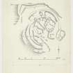
Fort, Settlement, and Scooped Enclosure, Kirkton Hill. On the summit at the S end of Kirkton Hill, a broad flat-topped ridge lying N and S and rising to a height of 897 ft. OD, there is a complex group of remains comprising, firstly, a small multivallate Iron Age fort; secondly, a settlement, probably of Romano-British date, consisting of circular huts and associated courts; and thirdly, a scooped enclosure of a type current in the later Middle Ages.
The position is a strong one as the E flank of the ridge falls steeply from the edge of the summit-area and, in common with the more gradual S and W slopes, is bounded by a wide belt of marshland; this would have constituted a formidable barrier before the land was improved, and the only easy approach would have been along the gently inclined crest of the ridge from the N. Christison (D Christison 1898) makes a brief reference to the site, but the plan which he reproduces is an extremely bad one.
The fort has been largely wrecked by the later occupations referred to above, while the defences on the E side have been obliterated by rig-cultivation of no great age; there is, however, just sufficient evidence to show that it was oval and measured approximately 190 ft. from N to S by 170 ft. from E to W within double, or possibly triple, ramparts and ditches.
The inner rampart has been completely levelled, but the W. half of its outline is traceable by a scarp (IA), while fragments of its ditch, 12 ft. wide and up to 15 in. deep, can be seen at the foot of the scarp on the N arc. A second rampart (IB), roughly concentric with the first, is represented on the NNE, by a mound 19 ft. thick but only a few inches high and showing no signs of stonework, and on the W and S sides by a terrace, while its ditch, 12 ft. wide and up to 20 in. deep, is visible, with only one interruption, round the N half of the perimeter. Some slight remains of another terrace (IC), concentric with and immediately below terrace (IB) on the S, suggests the existence of triple defences on this side. Lastly, an earthwork (D), consisting of a ditch 12 ft. wide and up to 2 ft. 5 in. deep with an upcast mound on its counterscarp, appears in a cultivated field on the NNE side of the fort and, emerging from the field, runs in a more or less straight line to the W shoulder of the ridge where it turns S in the form of a terrace and dies out 50 yds. beyond the angle on a steep declivity.
If, as seems likely, this earthwork is related to the fort, the fact that it is not concentric with the other defences, and also the reverse position of the ditch and bank, suggest that it is an addition to the original plan. The entrance to the fort was presumably situated on the SE., but both it and any internal structures contemporary with the ramparts have been obliterated in the succeeding phases.
At a time when the fort was in ruins the interior was converted into a settlement comprising at least nine huts (Nos. 1-9 on the plan) with courts attached. Traces of what may have been an enclosure wall of the settlement are seen approximately on the line of the inner rampart of the fort on the NNE and SSW (II); but on the N side two of the huts (2 and 6) overlie the ditch of the inner rampart, while a third (1) is situated in the space between the first and second ramparts. The huts range from 12 ft. 6 in. to 20 ft. in internal diameter, and except for No.9, which is simply a scoop, they are defined by low turf-covered banks showing no trace of stone- work. Three smaller circular hollows (Nos. 10-12 on the plan), one of which is enclosed by a bank, may represent storage-pits. The settlement is similar to the one that overlies the Iron Age fort of Hownam Rings (No. 301), which is known to have been occupied in the third century AD. (C M Piggott 1950)
The latest construction on the site, apart from a comparatively modern turf-dyke, appears to be a small enclosure (III) which overlies the second rampart and ditch of the fort on the E side but avoids the settlement. The interior, which measures 60 ft. by 50 ft., containes two slightly scooped courts, separated by a bank, with a terrace on the upper W side. Similar scooped enclosures have been dated in Peeblesshire to the 15th or 16th century. (R B K Stevenson 1941)
RCAHMS 1956, visited 1948
Note (18 August 2015 - 24 May 2016)
The remains of a fort overlain by a late Iron Age settlement are situated on the S end of the elongated summit of Kirkton Hill. Oval on plan, the fort measures internally about 58m from NE to SW by 52m transversely (0.25ha), but its defences have been obscured by the construction of the later settlement, which not only occupies the interior, but sprawls across the ramparts on the relatively level N flank, while on the E they are overlain by a rectilinear settlement enclosure and elsewhere ploughed-down by rig and furrow cultivation. Nevertheless, a belt of at least two ramparts and ditches, the outer with a counterscarp bank, can be seen stepping down the slope on the SW in a series of scarps and terraces, while on the N the inner forms a scarp beneath the later settlement, and the outer can be traced with an external ditch and a counterscarp bank. From outside the latter another ditch with an external bank extends across to the escarpment forming the W flank of the hill, before turning southwards and petering out on the slope. The fort may have been succeeded by an enclosure following the line of the inner rampart, but this has been incorporated into a series of yards and scooped courts associated with no fewer than thirteen round-houses, most of which are stone-founded and are probably late Iron Age in date; a markedly rectilinear enclosure containing two scooped courts was considered to date from the later Middle Ages by the RCAHMS investigators in 1948, but it is probably another element of the late Iron Age settlement. The position of the entrance into the fort is unknown, though the RCAHMS investigators suggest that it is probably in the obliterated SE sector of the defences.
Information from An Atlas of Hillforts of Great Britain and Ireland – 24 May 2016. Atlas of Hillforts SC3302
Sbc Note
Visibility: This is an upstanding earthwork or monument.
Information from Scottish Borders Council

