
Following the launch of trove.scot in February 2025 we are now planning the retiral of some of our webservices. Canmore will be switched off on 24th June 2025. Information about the closure can be found on the HES website: Retiral of HES web services | Historic Environment Scotland
Bonchester Hill


Settlement (Period Unassigned), Settlement (Prehistoric)(Possible), Settlement (Early Medieval)(Possible), Cinerary Urn(S) (Roman)
Site Name Bonchester Hill
Classification Settlement (Period Unassigned), Settlement (Prehistoric)(Possible), Settlement (Early Medieval)(Possible), Cinerary Urn(S) (Roman)
Canmore ID 55333
Site Number NT51SE 8
NGR NT 5960 1205
Datum OSGB36 - NGR
Permalink http://canmore.org.uk/site/55333


- Council Scottish Borders, The
- Parish Hobkirk
- Former Region Borders
- Former District Roxburgh
- Former County Roxburghshire
NT51SE 8 5960 1205.
(NT 5960 1205) Fort (NR)
OS 6" map (1924)
'... Several Roman urns have been found here ...'
Name Book 1857
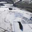
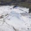
Earthworks, Bonchester Hill. This puzzling complex of earthwork, for which no date or purpose can be suggested without excavtion, lies on a broad spur running N from Bonchester Hill, 150 yds. N of and overlooked by the fort (RCAHMS 1956 No. 277) on the summit. It consists of an oval earthwork, lying on the crest of the spur at a height of 930 ft OD, and in conjunction with this a large subrectangular earthwork lying on the W slope of the spur. Both have been mutilated by quarrying, cultivation, and the construction of field boundaries.
The oval earthwork measures 172 ft. from N to S by 158 ft transversely. Entrance to it is gained through a gap in the NE arc of the defences, which are constructed as follows. For one-third of their length, from the E side of the entrance to the S extremity of the structure, they consist of a wasted rubble bank (A), with an internal ditch; at section X-X these measure respectively 20 ft. in width and 4 ft. in height, and 12 ft. in width and 2 ft. 6 in. in depth. There is no trace of an external ditch. A few yards short of the S extremity, where the internal ditch dies out, an outer bank (B) starts at a distance of 27 ft. from A. These two banks, with a medial ditch, form the remaining two-thirds of the defences. At section Y-Y, A stands to a height of 2 ft. above the interior and 3 ft. 3in. above the bottom of the ditch, and B stands to a height of 6 ft. above the bottom of the ditch and 2 ft. 6 in. externally. At the NW, side of the entrance A and B join round the end of the medial ditch. The defences on either side of the entrance are so alined theat the termination of A on the SE side is in line with B on the NW side, where A is 30 ft. inside it. This setting-back of one side of the entrance is unusual.
A low stony bank (C), 7 ft. in width and probably secondary to the main structure, divides the interior of the earthwork into two parts, crossing it without a break from the termination of A on the SE side of the entrance to a point on the SW arc. The area NW of C can by entered through the original entrance, while the other division is reached by way of a gap, which is clearly secondary, broken through the S arcs of A and B. In the NW division signs of secondary disturbance are seen in a broad shallow ditch about 85 ft. in length which lies close to the N arc of A, and a narrow earthen bank probably formed by upcast from it. The defences of the subrectangular earthwork appear to represent two main phases of construction.
One system encloses an area of which the approximate maximum measurement is 400 ft. both from N to S and transversely. A rubble bank (D) with an internal ditch springs at right angles from the SW arc of bank B of the oval earthwork, the ditch merging into the medial ditch between B and A. The bank (D) runs down the slope for 400 ft., beyond which a length of 45 ft. of it has been destroyed. From this point it turns NE and runs 470 ft. to a modern stone wall, the ditch along this stretch being intermittent. The bank curves slightly E before it is overlain and obliterated by the foundation of the wall, and the ditch likewise turn E, running up the slope beside the wall for 185 ft. before becoming lost among secondary works; it may thus be inferred that D originally followed the line now taken by the wall. At section Z-Z, D stands to a height of 6 ft. from the bottom of the ditch and up to 1 ft. 3 in. externally.
The remains of the other system of defences enclose an area within that enclosed by D, measuring about 340 ft. from E to W by 250 ft. transversely. A stony bank (E), which appears to be a ruined wall and which has no ditch, springs from the SW arc of B, 38ft. NNW of the starting point of D. It runs beside the internal ditch that is associated with D as far as the SW corner of the earthwork, but there it laaves the ditch and, after turning the corner, runs off NE. on a slightly diverging course. On reaching a distance of 80 ft. from D it turns again, on a rocky knoll, and runs E for 110 ft. and is then lost among secondary works. At section Z-Z, E stands to a height of 8 ft. 8 in. above the ground inside the earthwork and of 4 ft. above the outside. The entrance through both D and E must have been on the NE, where both are now obliterated. It should be emphasised that there is no direct way through A and B from the oval structure to the subrectangular earthwork.
An earthen bank (F) with a quarry ditch on its N side, evidently a land boundary, crosses the spur on which the earthworks are situated from W to E. It runs up from the W to the SW corner of the subrectangular earthwork where the excavtion of its ditch has caused the break of 45 ft. in D referred to above. It then runs along close to D as far as B, through which the ditch breaks into the medial ditch between B and A, thus effecting the complete isolation of the end of D. The bank (F) then runs E along the top of B for 100 ft., to where a modern track has made a gap 20 ft. in width. Beyond the gap bank and ditch reappear, and run off down the slope to the E. At section Z-Z, F stands to a height of 4 ft. above the bottom of the ditch and of 6 in. above the ground outside. Numerous banks and terraces lie within the sub-rectangular earthwork.
In the S a rectangular enclosure with an entrance in the NE corner can be distinguished, and immediately W of it there is a scooped court, bordered on the NW by a low bank and with a circular depression 20 ft. in diameter, possibly a hut-circle, in it SE portion. Between these two structures and the stone wall which now borders the NE edge of the site there are other banks, terraces, and hollows of indeterminate shape. They appear to have obliterated both D and E, and must therefore be of more recent date.
RCAHMS 1956, visited 1949
The earthwork on Bonchester Hill is unlikely to be later than the 11th century.
RCAHMS 1956
These earthswork are as described and generally as planned by RCAHMS.
Re-surveyed at 1/2500.
Visited by OS (JTT) 13 October 1965
Note (1956)
(i) MISCELLANEOUS EARTHWORKS: In the absence of excavation, over eighty earthworks in the county [Roxburgh] cannot by classified either because they do not conform to recognised types or because their plans are not sufficiently distinctive. A few of these, occupying commanding positions on hilltops or the crests of ridges, are unlikely to be later than the 11th century; such are Bonchester Hill (NT51SE 8), the group of earthworks on Whitcastle Hill (NT41SW 6), and five roughly D-shaped earthworks lying within a radius of two miles between the River Teviot and the Slitrig Water- Gray Hill 2 (NT40NE 13), Birny Knowe (NT40NE 12), Crom Rig (NT40NW 16), Dodburn (No.160, ii; NT40NE 7), and Pen Sike (NT40NE 8)- which are characterised by ramparts massive in proportion to their size. The majority, however, are situated on hillsides or in the bottoms of valleys, generally below the 800 ft contour, and are probably mediaeval. Most of these lower-lying structures, of which the outstanding examples are Timpendean (NT62SW 10), Iron Castle (NT61SW 7), and Scraesburgh (NT61NE 1), were evidently designed for habitation and presumably contained wooden buildings; but a few of the simpler earthworks such as Huntly Burn (No.51) may have been enclosures for stock.
RCAHMS 1956, 50
Note (17 August 2015 - 31 May 2016)
An inusual configuration of earthworks on the N spur of Bonchester Hill, overlooked by the better known fort occupying the summit, includes elements of defence which suggest that it should be considered in part as an element within the overall sequence of fortified settlement on the hill. At its core lies a fortified settlement situated on the crest of the spur, but this has evidently been adapted and modified in a series of stages, which includes the addition of a large rectilinear enclosure on the slope to the NW and the incorporation of both into the line of a linear earthwork that crosses the spur from E to W, the latter almost certainly representing one of the last elements to be constructed. The fortified settlement is oval on plan and measures internally 52m from NNE to SSW by 45m transversely (0.18ha). Its defences are best preserved around the W half of the circuit, where they comprise twin ramparts with a medial ditch about 5m in breadth, but on the S the inner appears to become the outer, forming the counterscarp to the ditch around the rest of the circuit as far as the entrance on the E, and there is no trace of a rampart along the inner lip of the ditch. While in 1949 RCAHMS investigators merely noted the unusual configuration of the ramparts that resulted at the entrance on the NE, it is perhaps more likely that this represents a modification of an original bivallate circuit, in which the inner rampart was extended across the ditch on the S to adopt the outer line on the E; this stratigraphy is partly obscured by the way the ditch of the linear earthwork has also been cut through the outer rampart on the S. At the entrance, like many other bivallate earthworks in Roxburghshire, the ramparts return and unite around the W ditch terminal, and doubtless was originally matched around the E terminal. Apart from a bank traversing from NE to SW, the interior is featureless. On the SW, the ditches of both the linear earthwork and the rectilinear enclosure are punched through the line of the inner rampart, the enclosure probably the remains of a late Iron Age settlement taking in an area of at least 1.2ha, within which there are evidence of both an inner and outer enclosure, a series of scooped courts and yards, and several possible round-houses.
Information from An Atlas of Hillforts of Great Britain and Ireland – 31 May 2016. Atlas of Hillforts SC3293
Sbc Note
Visibility: This is an upstanding earthwork or monument.
Information from Scottish Borders Council

