
Following the launch of trove.scot in February 2025 we are now planning the retiral of some of our webservices. Canmore will be switched off on 24th June 2025. Information about the closure can be found on the HES website: Retiral of HES web services | Historic Environment Scotland
Bonchester Bridge


Earthwork (Period Unassigned)
Site Name Bonchester Bridge
Classification Earthwork (Period Unassigned)
Canmore ID 55329
Site Number NT51SE 4
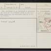
NGR NT 5848 1190
Datum OSGB36 - NGR
Permalink http://canmore.org.uk/site/55329


- Council Scottish Borders, The
- Parish Hobkirk
- Former Region Borders
- Former District Roxburgh
- Former County Roxburghshire
NT51SE 4 5848 1190.
Earthwork, Bonchester Bridge. On the right bank of Hob's Burn, 200 yds. above its junction with Rule Water, there are some slight remains of a small earthwork known as Duncan's Hole. It occupies a narrow tongue of land between two escarpments, one of which borders Hob's Burn, while the other, which lies at an angle of 45 to the first, has been formed by an old channel of Rule Water. Both escarpments are at the most 30 ft.
high, and decrease in height towards their point of junction. The artifical defences consist of a rampart and external ditch drawn in a semicircle across the neck of the penisnsula on the S side, and with its ends resting on the edges of the escarpments.
The rampart, which was presumably continuous in its original state, is of dump-construction: it has been almost entirely levelled on the W side of a fence which roughly bisects the site from NE to SW, but on the E side of the fence it measures 23 ft. in thickness at the base, 11 ft. in height internally, and 6 ft. in height externally. The ditch measures 25 ft. in width and up to 5 ft. in depth. There are indications of an entrance on the W side leading to Hob's Burn, but the interior, which
is roughly pear-shaped, with maximum measurements of 165 ft. from NNE
to SSW by 125 ft. from WNW to ESE, has been wrecked by drainage and contains no signs of structures. The earthwork may possibly be mediaeval.
RCAHMS 1956, visited 1948
(i) MISCELLANEOUS EARTHWORKS In the absence of excavations, over eighty, earthworks in the county cannot be classifed either because they do not conform to recognised types or because their plans are not sufficiently distinctive. A few of these, occupying commanding positions on hilltops or the crests of ridges, are unlikely to be later than the 11th century; such are Bonchester Hill (No. 278), the group of earthworks on Whitcastle Hill (No. 865), and five roughly D-shaped earthworks lying within a radius of two miles between the River Teviot and the Slitrig Water- Gray Hill 2 (No. 999), Birny Knowe (No. 995), Crom Rig (No. 1000), Dodburn (No. 160, ii), and Pen Sike (No. 168)- which are characterised by ramparts massive in proportion to their size. The majority, however, are situated on hillsides or in the bottoms of valleys, generally below the 800 ft. contour, and are probably mediaeval. Most of these lower-lying structures, of which the outstanding examples are Timpendean (No. 435), Iron Castle (No. 945), and Scraesburgh (No. 466), were evidently designed for habitation and presumably contained wooden buildings; but a few of the simpler earthworks such as Huntly Burn (No. 51) may have been enclosures for stock.
RCAHMS 1956
NT 5848 1190. This earthwork is as described by RCAHMS. There is no trace of the external ditch on the east side of the fence bisecting the earthwork from NE to SW.
Surveyed at 1/2500.
Visited by OS (WDJ) 25 March 1965
Note (17 August 2015 - 31 May 2016)
This small earthwork cuts off a promontory formed between the gully of the Hob's Burn and an old channel of the Rule Water. The ground thus falls away steeply for a height of some 9m on either side of the neck where the approach from the S is barred by a massive rampart 7m in thickness by over 3m in height internally and dropping 1.8m externally into a ditch 7.5m in breadth by 1.5m in depth. The pear-shaped interior, which slopes gently down northwards, measures 50m from NNE to SSW by a maximum of 38m transversely (0.12ha). There is a possible entrance on the W leading down to the Hob's Burn.
Information from An Atlas of Hillforts of Great Britain and Ireland – 31 May 2016. Atlas of Hillforts SC3292
Sbc Note
Visibility: This is an upstanding earthwork or monument.
Information from Scottish Borders Council

