
Bonchester Hill


Cultivation Remains (Period Unassigned), Fort (Period Unassigned), Settlement (Period Unassigned)
Site Name Bonchester Hill
Classification Cultivation Remains (Period Unassigned), Fort (Period Unassigned), Settlement (Period Unassigned)
Canmore ID 55300
Site Number NT51SE 10
NGR NT 59500 11700
Datum OSGB36 - NGR
Permalink http://canmore.org.uk/site/55300


- Council Scottish Borders, The
- Parish Hobkirk
- Former Region Borders
- Former District Roxburgh
- Former County Roxburghshire
NT51SE 10 59500 11700.
(Centred: NT 59481175) Fort : Hut Circles (NR)
OS 6" map (1924)
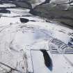
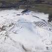
Fort, Bonchester Hill. This fort is situated on the summit of Bonchester Hill (1030 ft. OD), half a mile ESE of Bonchester Bridge. The hill is flanked on the W by the Rule Water and on the E by the Fodderlee Burn, to both of which it presents high and steep slopes; while to N and S it falls more gently, in the form of a ridge between the valleys. Its summit is formed by a flat-topped knoll, the N slopes of which merge into the shoulder of the ridge as this falls gently towards the confluence of the streams a mile and a half to the N; but those on the S arc are rocky and precipitous. Exploratory excavations were carried out in the fort by Dr A O Curle in 1906 (A O Curle 1910), and these were followed by more extensive excavations in 1950, from the report on which the following summary account has been prepared. (C M Piggott 1952)
The earliest fortification, which excavation showed to belong to the pre-Roman Iron Age, was a stone wall (I on plan) some 10 ft. to 12 ft. in width at the base which was built round the top of the summit-knoll to enclose an area measuring internally about 345 ft. from N to S by about 280 ft. transversely. It was composed of large stones uncoursed, laced with timber. Outside the N arc of this wall excavation revealed two more walls (IA and IB on plan) of which no trace remained on the ground. Wall 1A, which was composed of large stones, was 8 ft. from I and measured 17 ft. in thickness. Wall IB, at a distance of 8 ft. from IA, was 8 ft. 6in. in thickness and was composed of two faces between which earth and rubble had been inserted. It is possible that, as the slope N of the knoll was so gentle, the addition here of these outworks was considered necessary for defence purposes.
In this phase the fort had three entrances; one, 5 ft. in width, in the NW arc, another of the same size in the NE arc and the third, about 10 ft. in width, in the S arc. All three appear to be original. Finds, which include a ring-headed pin and part of a La Tene Ic brooch, suggest that this earliest fort was built, and occupied for a short time, early in the 1st century AD or a little before.
Within the fort there are the remains of the stone foundations of eight circular huts, varying in internal diameter from 19 ft. to 32 ft.; but as the remains of several similar huts also occur outside the fort, it cannot be said with certainty whether or not those within it are contemporary with the defences. There was apparently little or no occupation during Roman times. Later, however, further defences were added on the slopes beyond the base of the knoll. The nearest of these defences to the original fort now appears as a grass-grown bank which runs northward from a point on the lip of the rocky S side of the top of the knoll, turns round the N and NE arcs of the early fort and ends near the rocky slope on the E side of the knoll. The distance of this bank from the wall of the fort varies from as little as 32 ft. on the
NW arc to as much as 155 ft. on the S. The bank was cut in three places (cuttings, V, VI, and X on plan); on the N (VI) it was entirely composed of earth and light soil, while on the W (V and X) it was constructed of large stones with, in some places, a well-built outer face in which upright stones formed the lowest courses and horizontal ones the next above them. This technique is not uncommon in structures of the Roman period or the Dark Age, such as Nos. 672 and 201 (RCAHMS 1956).
Within the space between this work and the wall of the original fort here are the remains of the circular huts, sixteen in number, that have been mentioned as resembling those within the fort. At a later stage, two additional defences consisting of intermittent earthen banks with internal ditches were built on relatively flat ground below the knoll to enclose the earlier structures. These, as can be seen on the plan, swing away from the knoll in a wide loop to the E and S, while on the W, where only one persists, it encloses the remains of four more circular houses. Excavation showed that these banks had been repaired or reconstructed at least once. At cutting VII the inner bank was found to be composed of earth and rubble with a certain amount of stone-facing on either side; a double row of stakes had been driven into the top of the bank at intervals of about 1 ft. The same cutting showed that the outer bank, too, was made of earth and rubble; some large blocks which protrude from the inner slope of this bank ar probably the remains of a face which has been robbed.
RCAHMS 1956, visited 1950
A bead apparently of Dark Age type was found in a crevice on the rocky floor of one of the hut circles.
C M Piggott 1952
This fort is as described and generally as planned by RCAHMS.
Re-surveyed at 1/2500.
Visited by OS (JTT) 12 October 1965.
Note (17 August 2015 - 18 October 2016)
A complex fortification is situated on the summit of Bonchester Hill, which overlooks Bonchester Bridge from the E and presents rugged crag around its southern flank. Two episodes of excavation have occurred here, in 1906 (Curle 1910) and 1950 (Piggott 1950), but it would be unwise to think that either the complexity or the chronology of the sequence are understood. The sequence adopted in the RCAHMS County Inventory (RCAHMS 1956, 150-2, no.277) was worked out in co-operation with the more recent excavator, Mrs C M Piggott, and places the innermost enclosure on the hill first, though it should be noted that Mrs Piggott recognised evidence of earlier occupation beneath its wall where it was sectioned on both the N and W. Measuring from 3m to 3.6m in thickness, this wall enclosed an oval area measuring 105m from N to S by 85m transversely (0.67ha); the W section, however suggested that the surviving outer face rested on an earlier bank of rubble, beneath the inner edge of which, and resting on the traces of earlier occupation, the upper stone of a rotary quern was discovered. This may provide a terminus post quem for both phases of the circuit here in the late Iron Age. Further complexity was uncovered immediately outside the wall of the inner enclosure on the N, where two lines of ramparts were uncovered, of which only the outer could be traced laterally, extending down to an entrance on the cliff-edge to the E; considered outworks to provide additional protection on this flank, this is a patently naive interpretation, and the section revealed that the inner of them had been built across an earlier paved surface. Notable features of the inner enclosure are its three entrances, on the N, E and SW respectively, each displaying an unusual degree of elaboration. At the E entrance a track climbs obliquely up the slope from the gap in the outer rampart noted above, exposing the approaching visitor's left side, but where the track turns in through the entrance itself, the N terminal also turns inwards, at this point exposing the visitor's right side. In contrast, both terminals of the N entrance are turned inwards, while at the S entrance they are simply staggered to expose the visitor's right side. The outer defences are no less complex and for the purposes of description can be divided into three elements, namely an inner enclosure of some 1.6ha, an outer enclosure of 2.6ha taking in the N and W slopes above the cliff-line, and further ramparts below the cliff-line on the SE that extend the overall footprint of the fortifications by a further 1ha. The perimeter of the inner these enclosures, varied in the different sections cut across it, from a bank of soil on the N to an unstructured mound of large boulders on the W, while nearby on this side an outer face of orthostatic slabs set below horizontally coursed slabs was revealed, a form of construction that was only known to Mrs Piggott in what she considered to be early medieval contexts; no reliance can be placed upon this chronology today. Like the other ramparts, those of the outer circuit vary in character from cutting to cutting, from a single faced wall on the W to a two period construction of double ramparts and ditches on the N; the earlier phase was a simple dump, sealed beneath a turf-line in both ramparts, while in the second the inner was faced on either side and surmounted by a double row of posts driven into its crest. There appear to have been numerous entrances through these outer defences, though it is difficult on the information available to distinguish between original gaps and later breaks. Nevertheless, there are probably entrances through the inner of the outer enclosures on the NNE, ENE and WSW, while the plan published by Mrs Piggott shows another four gaps in the circuit on the NW quarter, and of the eight shown in the outer, those on the N, NNE, ENE W, and NW are likely to be original. The outer of the two lines below the cliff-edge also has a well-defined entrance on the SSE, though how these ramparts and ditches relate to the rest of the defences is quite unknown. No fewer than twenty-eight round-houses can be identified within the interior of the fort, most of them with stone founded walls and likely to be of late iron Age date; while Mrs Piggott asserted that several were contemporary with adjacent ramparts, where a relationship is in evidence they more typically overlie the defences.
Information from An Atlas of Hillforts of Great Britain and Ireland – 18 October 2016. Atlas of Hillforts SC3294
Sbc Note
Visibility: This is an upstanding earthwork or monument.
Information from Scottish Borders Council

