
Cavers Mains


Temporary Camp (Roman)
Site Name Cavers Mains
Classification Temporary Camp (Roman)
Canmore ID 55268
Site Number NT51NW 25
NGR NT 548 167
Datum OSGB36 - NGR
Permalink http://canmore.org.uk/site/55268


- Council Scottish Borders, The
- Parish Cavers
- Former Region Borders
- Former District Roxburgh
- Former County Roxburghshire
NT51NW 25 548 167.
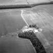
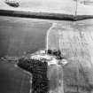
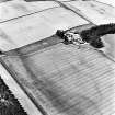
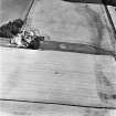
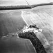
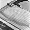
(NT 548 169) Roman Temporary Camp, Cavers Mains: Aerial photography has revealed a Roman camp on the E end of a ridge, at 500 ft OD, at Cavers Mains. About 1,000 ft of the SE side, 600 ft of the NE side, with the rounded angle between them is visible as a cropmark, with a slight change in direction in the SE side at a gate with a tutulus.
J K St Joseph 1965
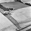
The remainder of the NE side (some 1,050 ft long), the rounded N angle, and part of the NW side have now been recorded.
J K St Joseph 1969
There are no surface remains of this camp. The site is now under plough.
Visited by OS (BS) 10 April 1975
Further aerial photographs taken by the RCAHMS in 1980 and 1995.
Publication Account (17 December 2011)
First discovered from the air in 1962 by St Joseph (1965:78), the camp at Cavers Mains lies on the eastern edge of a ridge above the River Teviot, just north-east of Hawick. The camp of Eastcote lies less than 1km to the northwest in a bend in the river. Parts of three sides of the camp are known through cropmarks, and it measures 328m from north-west to south-east by at least 321m transversely. Entrances protected by tituli are visible in the north-east and south-east sides. If that on the south-east side is close to the centre of that side, the camp probably enclosed at least 11.5ha (28 acres).
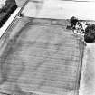
St Joseph illustrated the possible south angle and southwest side of the camp (RCAHMS St Joseph Collection: DC 37307) but did not publish reference to additional sides being located. While some linear cropmarks are visible in this field, the south-west side of the camp could not be confirmed by air-photography evidence.
R H Jones
Sbc Note
Visibility: This site is visible as a cropmark.
Information from Scottish Borders Council

