
Following the launch of trove.scot in February 2025 we are now planning the retiral of some of our webservices. Canmore will be switched off on 24th June 2025. Information about the closure can be found on the HES website: Retiral of HES web services | Historic Environment Scotland
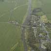
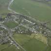
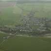
Denholm, General


Village (Period Unassigned)
Site Name Denholm, General
Classification Village (Period Unassigned)
Alternative Name(s) Denholm Village
Canmore ID 55219
Site Number NT51NE 30
NGR NT 56828 18532
NGR Description Centred on NT 56828 18532
Datum OSGB36 - NGR
Permalink http://canmore.org.uk/site/55219


- Council Scottish Borders, The
- Parish Cavers
- Former Region Borders
- Former District Roxburgh
- Former County Roxburghshire
EXTERNAL REFERENCE:
Hawick Museum:
1835 plan of Denholm village with gardens and lands to be given to the feuars in exchange for their rights to turfs in Denholm Mill.
Sbc Note
Post medieval/Early Modern core of village. Shown on Pont's Map as Denholme.
Information from Scottish Borders Council Historic Environment Record
(n.d.)

