Accessibility

Font Size

100% 150% 200%

Background Colour

Default Contrast
Close Reset

Pricing Change

New pricing for orders of material from this site will come into place shortly. Charges for supply of digital images, digitisation on demand, prints and licensing will be altered. 


Bedrule

Settlement (Period Unknown)

Site Name Bedrule

Classification Settlement (Period Unknown)

Canmore ID 55204

Site Number NT51NE 17

NGR NT 5989 1909

Datum OSGB36 - NGR

Permalink http://canmore.org.uk/site/55204

Ordnance Survey licence number AC0000807262. All rights reserved.
Canmore Disclaimer. © Bluesky International Limited 2025. Public Sector Viewing Terms

Toggle Aerial | View on large map

Digital Images

Oblique aerial view.
Oblique aerial view.Bedrule, oblique aerial view, taken from the SE, centred on the cropmarks of a double-ditched settlement.Bedrule, oblique aerial view taken from the E, centred on the cropmarks of a settlement.Oblique aerial view centred on the cropmarks of the settlement, taken from the NE.Oblique aerial view.Bedrule, NT51NE 17, Ordnance Survey index card, page number 2, VersoBedrule, oblique aerial view taken from the SE, centred on the cropmarks of a settlement.Bedrule, oblique aerial view, taken from the S, centred on the cropmarks of a settlement.Bedrule, oblique aerial view taken from the SW, centred on the cropmarks of a settlement.Oblique aerial view.Bedrule, NT51NE 17, Ordnance Survey index card, RectoOblique aerial view.Oblique aerial view.Bedrule, NT51NE 17, Ordnance Survey index card, RectoBedrule, oblique aerial view, taken from the the NW, showing soilmarks of a double-ditched settlement.Bedrule, oblique aerial view, taken from the the SE, showing soilmarks of a double-ditched settlement.Bedrule, oblique aerial view, taken from the the E, showing soilmarks of a double-ditched settlement.Bedrule, oblique aerial view taken from the SE, centred on the cropmarks of a settlement.Oblique aerial view centred on the cropmarks of the settlement, taken from the ESE.Bedrule, NT51NE 17, Ordnance Survey index card, page number 1, RectoBedrule, oblique aerial view, taken from the SW, centred on the cropmarks of a double-ditched settlement.Oblique aerial view.Oblique aerial view.Oblique aerial view.Bedrule, oblique aerial view, taken from the NW, centred on the cropmarks of a double-ditched settlement.Bedrule, oblique aerial view, taken from the SW, centred on the cropmarks of a double-ditched settlement.Oblique aerial view centred on the cropmarks of the settlement, taken from the SW.Oblique aerial view.Oblique aerial view.Oblique aerial view.Bedrule, oblique aerial view, taken from the SE, centred on the cropmarks of a settlement.Bedrule, oblique aerial view, taken from the E, centred on the cropmarks of a settlement.Oblique aerial view.Oblique aerial view.Oblique aerial view.Bedrule, oblique aerial view, taken from the NE, centred on the cropmarks of a double-ditched settlement.Bedrule, oblique aerial view, taken from the SSW, centred on the cropmarks of a settlement.Oblique aerial view centred on the cropmarks of the settlement, taken from the SSE.Oblique aerial view.Bedrule, NT51NE 17, Ordnance Survey index card, Recto

Administrative Areas

  • Council Scottish Borders, The
  • Parish Bedrule
  • Former Region Borders
  • Former District Roxburgh
  • Former County Roxburghshire

Archaeology Notes

NT51NE 17 5989 1909.

(NT 5989 1909) Enclosure (NR) (site of )

OS 6" map (1971)

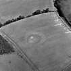
Earthwork, Bedrule (Site): This earthwork stood in a field formerly known as the Stirk-rigg, 1200 yds N of Bedrule farm. It is said (NSA 1845) to have been completely effaced by cultivation a century ago, but the site can still be traced by a circular hollow 150 ft in diameter.

RCAHMS 1956, visited 1939

The site of this earthwork is at that part of the summit of a hill where it falls way to the W. The work has been scooped out of the hill to obtain a level floor, leaving a hollow with a rear (E) scarp about 2.0 m high. The entrance appears to have been in the W side. The name 'Stirk-rigg' is not known locally.

Surveyed at 1:2500.

Visited by OS (RD) 1 March 1967

This settlement has been photographed both by CUCAP and the RCAHMS.

Activities

Note (15 August 2015 - 31 May 2016)

The site of this fortified settlement is marked by a deep hollow situated just off the crest of this hill, where the ground begins to fall away more steeply to the WNW. First noted in the Statistical Account, by 1837 it had already been ploughed down (NSA, 3, Roxburghshire, 283), but its perimeter has been revealed by cropmarks, comprising twin ditches set some 4m apart, the inner up to 4m in breadth and the outer about 2m. Roughly circular on plan, the scooped interior measures about 55m in diameter (0.23ha) and has been dug up to 2m into the slope on the E. The entrance is on the W.

Information from An Atlas of Hillforts of Great Britain and Ireland – 31 May 2016. Atlas of Hillforts SC3283

Sbc Note

Visibility: This is an upstanding earthwork or monument.

Information from Scottish Borders Council

References

MyCanmore Image Contributions


Contribute an Image

MyCanmore Text Contributions