
Pricing Change
New pricing for orders of material from this site will come into place shortly. Charges for supply of digital images, digitisation on demand, prints and licensing will be altered.
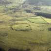
Blakebillend


Field System (Prehistoric), Settlement (Prehistoric), Quern (Period Unassigned)
Site Name Blakebillend
Classification Field System (Prehistoric), Settlement (Prehistoric), Quern (Period Unassigned)
Canmore ID 55147
Site Number NT50NW 1
NGR NT 5150 0630
Datum OSGB36 - NGR
Permalink http://canmore.org.uk/site/55147


- Council Scottish Borders, The
- Parish Cavers
- Former Region Borders
- Former District Roxburgh
- Former County Roxburghshire
NT50NW 1 5150 0630.
(NT 5150 0627) Earthworks (NR)
OS 6" map (1958)
An earthwork is situated on the end of a spur which projects NE from Burnt Craig, at a height of 900 ft OD; the site has little natural strength. The earthwork, which encloses a roughly triangular area a little over 3 acres in extent, lies partly on the narrow crest of the spur and partly on the E flank. Apart from mutilations at the W and SSE corners, the circuit of the defences is still well defined, although the defences themselves are not in a uniform state of preservation. Originally they appear to have comprised double ramparts and ditches, with a slight upcast mound on the counterscarp of the outer ditch. This latter feature survives only at the N apex, while the outer ditch has been obliterated by cultivation along the greater part of the E side and intermittently elsewhere. The inner rampart has disappeared on the whole of the E side, and part of the NW side. Elsewhere the ramparts appear as turf-covered banks, the inner one standing to a maximum height of 3 ft 3 ins internally and 6 ft 6 ins externally, and the outer one to a maximum height of 6 ft 6 ins both internally and externally. Though sheep-rubbings show that their cores are composed of earth and rubble from the ditches, traces of revetting walls can be seen embedded in their flanks.
There are two original entrances through the defences, on the NE and SW sides. Within the interior, which has recently been used as a mortar range, there are the remains of a series of enclosures, bounded by turf-covered walls, and of five circular huts. Four of these latter (1-4 on plan) exhibit some slight stone foundations while no 5 is merely a shallow, scooped floor. One of the huts (4) overlies the site of the inner rampart, and the whole complex, which bears a marked resemblance to the Romano-British settlement that succeeded the Early Iron Age forts at Hownam Rings (NT71NE 1) may well be secondary.
Occupation of the site in the Roman period is indicated by the discovery of two pieces of beehive quern (i) an upper stone, now in Hawick Museum, was found in the ditch on the E side of the earthwork, and (ii) a small fragment only, was found at the point marked X on plan. Further evidence is provided by what seem to be traces of "Celtic" fields, which reached their maximum extension in the Romano-British period, underlying the rig-cultivation on the NW flank of the spur between the earthwork and the Slitrig Water.
Several linear earthworks run from the earthwork to NW, N and SSW. Those that descend N and NW appear to be field divisions and may be of no great age. The first of these linear works (A on plan), consisting of much-spread bank and a ditch which has been used in the modern drainage system, runs from the SSE corner of the earthwork to the NW corner of the field lying S of the road to the artillery range. Disappearing there, it can again be found beyond the W corner of the field and followed SW for 200 yds until it is lost in moorland. The second earthwork (B on plan), again a bank and ditch, in places rock-cut, originates at the W corner of the earthwork and runs towards the SSW on a course that appears to be converging with that of its neighbour. On peaty moorland the ditch becomes filled up and the bank alone is visible, resembling a causeway about 12 ft wide and 1 ft high. Obliterated by old cultivation N of Lansidebrae, it reappears above the walled fields W and SW of the house and can be traced as far as the W corner of the south-westernmost of these; in this section, however, the ditch seems to have been used as a road. Beyond the W corner of this field no sign of the work can be seen, and it may have turned downhill as the stone dyke does today. This linear earthwork seems to be an ordinary boundary-mark defining a block of land on the W side of the Langside Burn.
RCAHMS 1956, visited 1948
The earthwork as described, and generally as planned, by the RCAHMS.
NT 5156 0620 to NT 5138 0593. A linear (RCAHMS 'A') as described, consisting of a bank and ditch, overall width about 7.0 m.
NT 5140 0629 to NT 5103 0566. A linear (RCAHMS 'B') consisting of a turf-covered bank 0.3 m average height and a slight ditch. The overall width is about 7.0 m from NT 5140 0629 to NT 5133 0602 where the ditch lies on the E side of the bank. From NT 5133 0602 to NT 5125 0595 the ditch lies on the NW side of the bank. At NT 5125 0595 the ditch fades and the earthwork continues as a spread bank, about 6.0 m wide and 0.3 m high, until it fades completely at NT 5103 0566.
Earthwork and Linear 'A' surveyed at 1:2500.
Visited by OS (JTT) 13 April 1965
(NT 5150 0627) Settlement (NR)
OS 25" map (1967)
The earthwork and settlement are generally as described and planned by the RCAHM. A ditch breaching the outer rampart on the E side appears to be a relatively recent feature. Linear earthworks 'A' and 'B' are as described by the previous authorities except that the latter fades at NT 5102 0562. A linear bank and ditch extending from NT 5057 0506 to NT 5041 0480 is probably the alleged second section of linear 'B' noted by the RCAHMS. It is reduced in parts but overall it measures 3.5 m wide with the bank 0.8 m high at best.
A linear ditch extends from NT 5140 0629, the SW corner of the settlement, to NT 5120 0637 above the steep gully of William's Cleuch. It measures 3.8 m wide by 0.4 m deep at the upper end, gradually reducing in size down the slope towards William's Cleuch. At its eastern end it is overlaid by the bank of linear 'B' where the latter crosses, suggesting that the ditch predated the ditch and bank of linear 'B'.
Surveyed at 1:10,000.
Visited by OS (JB) 24 December 1979
Photographed by the RCAHMS.
Probable fragment of bun-shaped quern; RMS HD 767.
E J MacKie 1971
Some damage and mutilation may have been caused to the monument by action during World War II. Evidence from vertical air photographs (106G UK 433, 3227-3228, flown 24 June 1945), would suggest that there are many fresh excavations within the settlement and that these may have been firing points for the adjacent tracked target range (NT50NW 26.00) to the SW. The photographs show a large group of shell holes to the W and SW of the range, suggesting that the firing point was somewhere to the NE of the military installation.
Information from RCAHMS (DE), November 2006
Note (12 August 2015 - 4 August 2016)
This unusual fortified enclosure lies just off the crest of Blakebillend, dropping down gently eastwards immediately E of the summit of the spur. An irregular polygon on plan, it measures about 150m from NE to SW by 145m transversely (1.6ha) within two ramparts accompanied by external ditches. The inner rampart has been stone-faced, and a run of its outer face is still visible on the S, but large sectors on the NW and NE have apparently been levelled during a later phase of occupation, Nevertheless, where best preserved the inner stands 1m high internally, while the outer is up to 2m high. The ditch between them varies from 4.5m to 7.5m in breadth, contrasting with the relatively minor scale of the outer ditch, which has been virtually obliterated by later cultivation; possibly this ditch was not associated with the construction of the original circuit, but results from additions where it has been incorporated into the lines of a series of later linear earthworks and field boundaries. Later usage has broken through the defences at several places, but there are at least two original entrances, on the NNE and WSW respectively, and at both the ramparts return and unite around the terminals of the ditches. The greater part of the interior is occupied by what is probably a late Iron Age settlement comprising a series of rectilinear and curvilinear yards and at the footings of at least five stone walled round-houses, one of which lies on the line of the inner rampart on the SE. The surrounding area contains extensive traces of earlier fields and boundary works, some of which are evidently associated with post-medieval rig-systems, but these also overlie a system of small rectilinear fields, which is likely to be late Iron Age in date.
Information from An Atlas of Hillforts of Great Britain and Ireland – 04 August 2016. Atlas of Hillforts SC3275
Sbc Note
Visibility: This is an upstanding earthwork or monument.
Information from Scottish Borders Council

