
Kincraig Battery


Coastal Battery (Second World War), Observation Post (Second World War)
Site Name Kincraig Battery
Classification Coastal Battery (Second World War), Observation Post (Second World War)
Alternative Name(s) Forth Defences; Earlsferry; Kingcraig Point; Kincraig Hill; Craig Heugh
Canmore ID 55122
Site Number NT49NE 44
NGR NT 4673 9991
NGR Description Centred NT 4673 9991
Datum OSGB36 - NGR
Permalink http://canmore.org.uk/site/55122


- Council Fife
- Parish Elie
- Former Region Fife
- Former District North East Fife
- Former County Fife
A field survey was undertaken of the Kincraig Battery and Camp by HES Archaeological Survey (J. M. Hepher, A. T. Welfare, A. K. Kilpatrick. P. M. Bethune), 6-10 November 2023
NT49NE 44.00 centred 4673 9991
NT49NE 44.01 NT 46597 99758 Radar Site
NT49NE 44.02 NT 46725 99909, NT 46820 99911 and NT 46862 99961 Gun-emplacements
NT49NE 44.03 NT 46790 99958 Observation post (Battery OP)
NT49NE 44.04 c. NT 4697 9993 Searchlight platform
NT49NE 44.05 Centred NO 4677 0004 Military camp
NT49NE 44.06 NO 47156 00026 Observation Post
NT49NE 44.07 NT 46555 99723 Searchlight Platform
Battery may have been proposed, and not implemented.
N H Clark 1986
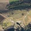
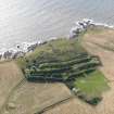
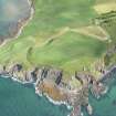
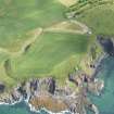
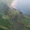
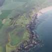
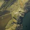
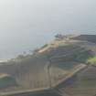
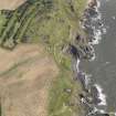
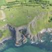
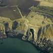
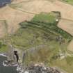
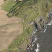
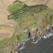
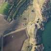
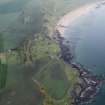
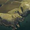
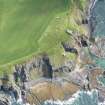
This coast battery, constructed in brick and concrete, is situated to the S of Kincraig Hill, overlooking Macduff's Cave (NT49NE 1).
A World War Two medium calibre battery consisting of two 6-inch Mk VII/II guns which were installed in 1939 and replaced in 1942 by Mk VII/v guns. The battery was again altered in 1943 with the earlier 6-inch guns being replaced by three 6-inch Mk XXIV/v guns, these being removed in 1956.
In addition, a radar observation post (NT49NE 44.01, NT 4660 9975), searchlight emplacement and a battery observation post survive.
J Guy 1994; NMRS MS 810/3; PRO WO/192/255
Site recorded by Maritime Fife during the Coastal Assessment Survey for Historic Scotland, Kincardine to Fife Ness 1996
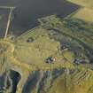
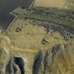
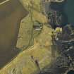
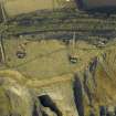
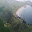
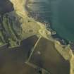
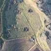
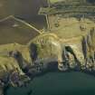
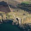
This coast battery is visible on vertical air photographs (106G/Scot/UK 4, Part II, 6165-7, flown 14 April 1946) which show that there are three large gun emplacements (also depicted on the OS 1:10000 scale map (1987), two with guns still mounted with a battery observation tower. Immediately to the N (and upslope) is the accommodation camp with the electricity power house and magazine. All buildings are roofed on the photographs. In addition, a communications trench is visible to the rear of the gun emplacements and observation tower. Also visible is the perimeter fence which surrounds this military installation.
Information from RCAHMS (DE), September 2002.
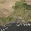
The gun battery overlooks the Firth of Forth and is situated on Kincraig Hill.
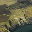
Most of the structures have either been demolished or reduced to a pile of rubble. The three large gun emplacements, numbered from W to E 1-3 (NT49NE 44.02), retain their gun pits and holdfasts, but the associated superstructure has been deliberately collapsed and is now reduced to a pile of concrete and brick. Other surviving buildings, notably the Obsevration Tower (NT49NE 44.03) have been reduced to piles of either brick or concrete, but the accommodation camp has been almost totally removed with only a few hut bases remaining in the area. A BPR Observation Post still stands to roof height at NO 47156 00026, the walls having several loopholes. At c.NT 4705 0000 is a small holdfast which straddles the Fife Coastal path, the bolts still visible trodden into the earth. This small holdfast may have been for a light anti-aircraft gun or UP mounting (unrotating fixed projectile).
The radar site (NT49NE 44.01) survives relatively intact, the radar observation post and transmitter/receiver (Tx/Rx) block retains the roof, with entrances at the N and S of the building. A small engine room survives at the N end of the building along with two single storey concrete structures with entrances at their S end (NT 46550 99782 and NT 46602 99802), 46m NW and 43m N of the main Tx/Rx building. The 1946 vertical air photographs (ibid) show that there was a roof mounted aerial.
Visited by RCAHMS (DE), 16 May 2007
Note
NT49NE 44 NT 4673 9991 (centred)
NT49NE 44.01 NT 46597 99758 (centred) Radar Site
NT49NE 44.02 NT 46820 99911 Gun Emplacements
NT49NE 44.03 NT 46790 99958 Observation Post
NT49NE 44.04 NT 46960 99931 Searchlight Emplacement
NT49NE 44.05 NT 4672 9999 (centred) Military Camp
NT49NE 44.07 NT 46552 99725 Searchlight Platform
NT49NE 44.08 NT 46935 99988 (centred) Fence, Gateways
NT49NE 44.09 NT 46906 99987 Rocket Projector Battery
NT49NE 44.10 NT 46839 99917 Weapons Pit (Possible)
NT49NE 44.12 NT 46778 99967 Magazines
NT49NE 44.13 NT 46867 99986 Water Tank
NT49NE 44.14 NT 46824 99917 Command Post
NT49NE 44.15 NT 46814 99983 Telecommunications Structure
NT49NE 44.16 NT 46791 99973 Trench
NT49NE 44.17 NT 46786 99975 Storehouse
NT49NE 44.18 NT 46761 99920 Gun Emplacements
NT49NE 44.19 NT 46774 99913 Ordnance Survey Control
NT49NE 44.20 NT 46772 99996 Storehouse
NT49NE 44.21 NT 46707 99950 Storehouse
NT49NE 44.22 NT 46858 99982 Storehouse
NT49NE 44.23 NT 46941 99924 Guardhouse
NT49NE 44.24 NT 46968 99955 Pillar
NT49NE 44.25 NT 46825 99876 Wall
NT49NE 44.26 NT 47075 99946 Building Platform, Searchlight
NT49NE 44.27 NT 46749 99862 Fence, Pits
NT49NE 44.28 NT 46878 99964 Pit
NT49NE 44.29 NT 4683 9995 Searchlight (Possible)
NT49NE 44.30 NT 4677 9994 (centred) Machine Gun Posts
NT49NE 44.31 NT 46805 99947 (centred) Track
NT49NE 44.32 NT 46815 99946 Radio Mast
NT49NE 44.33 NT 46652 99995 NAAFI Building
NT49NE 44.34 NT 46701 99976 Engine House
NT49NE 44.35 NT 46573 99793 Engine Houses, Radar Station
NT49NE 44.36 NT 46578 99779 Nissan Hut, Radar Station, Shelter
NT49NE 44.37 NT 46564 99775 Drain, Inspection Hatch, Radar Station
NT49NE 44.38 NT 46572 99797 Fence, Gate, Radar Station
NT49NE 44.39 NT 46536 99745 Machine Gun Post, Radar Station
NT49NE 44.40 NT 46619 99799 Rocket Projector Battery, Radar Station
NO40SE 1202 NO 47103 00038 Trench
NO40SE 1218 NO 46830 00006 Tanks
NO40SE 1217 NO 46908 00008 (centred) Gun Emplacement
NO40SE 1219 NO 46811 00002 Engine House
NO40SE 1220 NO 46765 00000 Water Tank
NO40SE 1223 NO 46764 00023 Steps
NO40SE 1224 NO 46761 00031 Steps
NO40SE 1225 NO 46886 00051 Car Park
NO40SE 1226 NO 46893 00037 Guardhouse
NO40SE 1227 NO 46756 00010 Culverts
NO40SE 1228 NO 46872 00009 Steps
NO40SE 1229 NO 46867 00002 Building
NO40SE 1230 NO 46957 00004 Weapons Pits
NO40SE 1231 NO 46931 00084 (centred) Military Road
NO40SE 1232 NO 46725 00033 Ablution Block, Coal Store
NO40SE 1233 NO 46741 00044 Latrine
NO40SE 1234 NO 46696 00030 Enclosure, Tank
NO40SE 1235 NO 46635 00026 Tank
NO40SE 1236 NO 46672 00024 Steps
NO40SE 1237 NO 47158 00027 Observation Post

