
Gullane, Saltcoats Road, Saltcoats Castle


Architectural Fragment (17th Century), Castle (16th Century)
Site Name Gullane, Saltcoats Road, Saltcoats Castle
Classification Architectural Fragment (17th Century), Castle (16th Century)
Canmore ID 55082
Site Number NT48SE 7
NGR NT 48541 81877
Datum OSGB36 - NGR
Permalink http://canmore.org.uk/site/55082


- Council East Lothian
- Parish Dirleton
- Former Region Lothian
- Former District East Lothian
- Former County East Lothian
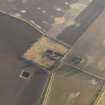
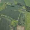
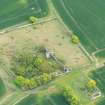
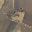
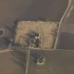
(NT 48541 81877) Saltcoats Castle (NR) (remains of)
OS 6" map (1968)
Saltcoats Castle is described in the Object Name Book of the Ordnance Survey (ONB) as' The ruins of an ancient castle near Saltocats House , the only portion remaining are the E end, the walls are a fraction of the ...
Name Book 1853
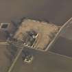
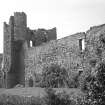
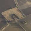
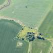
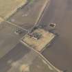
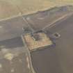
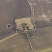
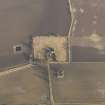
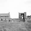
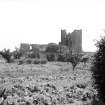
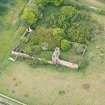
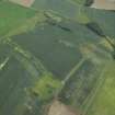
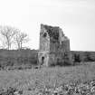
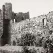
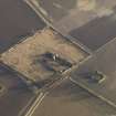
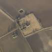
The late 16th c Saltcoats Castle consists of a main structure 72' by 23 1/2' which forms the S side of a courtyard with two projecting angle towers at the W end. The N wall and inner partitions of the main building are absent. Only the ground floor of some subsidiary buildings at the NE corner remain. The enclosing walls exist but are much repaired. The castle was still inhabited about 1790 but most of the building was removed for agricultural improvements about 1823-4.
RCAHMS 1924, visited 1913
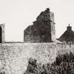
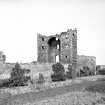
Saltcoats Castle is generally as described except that the main block, which is virtually intact, forms the W side of the courtyard.
Visited by OS (RDL) 21 November 1962 and (SFS) 11 July 1975
The armorial stone of the builder, Patrick Levingtoun of Saltcoats, now mounted over the front door of a nearby cottage, probably came from over the door of the castle, and the date must be 1592 (the second digit crudely recut as a 3).
C McWilliam 1978
NT48SE 30 48501 81917 Dovecot
NT48SE 52 48503 81890 Market Garden house
Field Visit (6 July 1913)
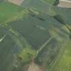
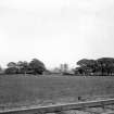
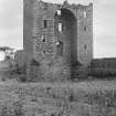
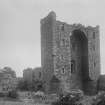
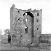
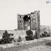
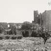
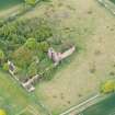
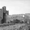
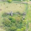
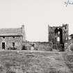
The remains of this castle are situated on a level site a little over ½ mile due south of Gullane. The ruin has at first sight the appearance of being considerably older than it really is, but analysis of the structure shows it to have been built towards the end of the 16th century. Erected on a courtyard plan, the main structure formed the southern boundary, and a range of subsidiary buildings has apparently run parallel to this on the north with a courtyard wall on east and west to complete the enclosure (fig. 61).
The portions now remaining are fragmentary; of the main buildings the north wall and the inner partitions are absent; of the buildings on the north only one portion at the north-east angle is complete and that only on the ground floor. The heavy walls usually found enclosing the gardens are still in existence but have been extensively patched.
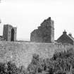
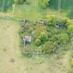
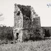
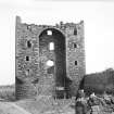
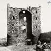
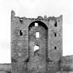
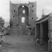
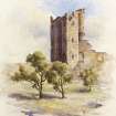
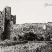
The main structure is an oblong building, measuring externally 72 feet from east to west and 23 ½ feet from north to south, and terminates on the west in projecting angle towers, which are circled at base and develop as they rise to a square carried on corbels some distance above the ground. At a later period the interspace between the towers has been bridged by a segmental arch, as though the builder had decided to add to a domestic structure details of an earlier age. Furthering this idea the window in the interspace between the towers is the height of a doorway, but has clearly been half-glazed and served no other purpose than that of lighting a portion of the first floor. In the north tower are gunloops, the lower cruciform, the upper keyhole-shaped; these appear to have been more ornamental than useful. An unusual feature is the provision of no less than 14 close set gargoyles on the southern face above the towers (fig. 54).
The building is constructed of coursed rubble with ashlar dressings. It has been entered from the courtyard by a doorway, now represented only by its west jamb, in the north wall close to the tower at ground level. The ground floor contained three apartments ceiled with semicircular barrel-vaults; the central one ran north and south, those at the ends east and west. These chambers have narrow slits on the south admitting little light. A narrow turnpike staircase in the north tower gives access to the first floor level and there terminates. The first floor has been lit by large windows in the south wall, of which the upper portions have been glazed, the lower closed by shutters.
Above this floor a high pitched roof completed this portion; but on the extreme west the portion containing the towers is carried up two additional storeys, which are reached from a turret-staircase contained within the re-entering angle of the south tower and wall. Above the upper storeys on the west there may have been a parapet walk.
The only surviving portion of the north range is a vaulted chamber containing a wide fireplace at its eastern end provided with an oven and an outlet for slops. This was the kitchen. South-west of the castle the well remains and is in use but has been repaired in brick.
Over the doorway of a cottage west of the castle is an heraldic panel within a crimped border containing beneath a helmet and mantling a shield charged per pale: dexter, a bend with a boar's (or otter's) head (?) couped, and sinister, a fess between three roundles. Flanking the shield are the initials P. L. and M. F., which have been re-cut and the date 1390, which is apparently a misreading of an original 1590 (cf. below). This stone probably came from above the doorway of the castle and the date 1590 would agree with the detail of the building.
DOVECOT. A rectangular dovecot measuring externally 14 ¼ feet by 16 1/3 feet and 25 feet in height, which lies north-north-west of the castle, may be a contemporary structure.
DETAILS. In the north wall of the garden is a door lintel inscribed: 16 G.L. 95. In the west wall is a wide arched entrance with a segmental head, which has been built up.
HISTORICAL NOTE. The initials P.L. are those of Patrick Levingtoun of Saltcoats(" Saultcottis ") on record in 1588-9, 1594 &c (1). Nesbit says he had seen an armorial seal charged with a bend and ‘an otter's (or boar's) head couped in chief’ with the legend ‘Sig. Patricii Livingtoun de Saltcoat 1593’ (2). These arms are given for ‘Levingtoun of Saltcottis’ by Lindsay and are those on the panel here, save that the head is more probably that of a bear muzzled. The bend blazon is probably from the coat of the de Vaux of Dirleton, which showed : argent a bend gules; the colours of the Levingtoun coat also according to Lindsay (3). The impaled arms are those of Fawside, indicating a wife of that family (cf. Art. No. 193). The 1695 initials are those of George Levingtoun, who died before 1705 and was the last male of the line (4). The place was still inhabited c. 1790, but ‘the principal part of the building’ was ‘removed for agricultural improvements 20 years ago’ (i.e.,, c. 1823-4) (5) .
RCAHMS 1924, visited 6 July 1913.
(1) Reg. P.C. iv., 357, v., 625; (2) Heraldry i., p. 104; (3) cf. further Introd., p. xxiv; (4) Stodart's Scottish Arms, ii., p. 322.; (5) Lamp of Lothian, p. 122 note.

