
Following the launch of trove.scot in February 2025 we are now planning the retiral of some of our webservices. Canmore will be switched off on 24th June 2025. Information about the closure can be found on the HES website: Retiral of HES web services | Historic Environment Scotland
Archerfield Estate


Midden(S) (Prehistoric)
Site Name Archerfield Estate
Classification Midden(S) (Prehistoric)
Alternative Name(s) Gullane Bay; Black Rocks; Firth Of Forth; Outer Forth Estuary
Canmore ID 55028
Site Number NT48NE 8
NGR NT 491 853
Datum OSGB36 - NGR
Permalink http://canmore.org.uk/site/55028


- Council East Lothian
- Parish Dirleton
- Former Region Lothian
- Former District East Lothian
- Former County East Lothian
NT48NE 8 491 853.
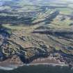
(NT 491 853) On the links of Archerfield Estate to the E of Gullane Bay and N of Black Rocks are four large ravines running E-W. The second of these from the S extends for several hundred yards. On its S side is a mound of sand and loam on which have been found three middens. The first, 12' x 9' lay towards the W of the mound, the second, of similar size, 5' to the E, and a further 20' E lay the third. They were excavated in 1908. Mixed in with a mass of shells and animal bones were a few flint scrapers and flakes, a bone pin and fragments of twenty-seven beakers of various types. A small copper coin of Charles II was also found.
A O Curle 1908; J Abercromby 1912; RCAHMS 1924; D L Clarke 1970.
It is not possible to identify the site of these middens. No further information.
Visited by OS (SFS) 17 July 1975.

