|
Photographs and Off-line Digital Images |
G 90424 PO |
Records of the Scottish National Buildings Record, Edinburgh, Scotland
|
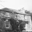
General view from SE. |
8/1953 |
Item Level |
|
|
Photographs and Off-line Digital Images |
EL 7542 |
List C Survey |
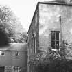
View from S. |
1975 |
Item Level |
|
|
Photographs and Off-line Digital Images |
EL 7543 |
List C Survey |
View from SW. |
1975 |
Item Level |
|
 |
On-line Digital Images |
DP 083140 |
RCAHMS Aerial Photography Digital |
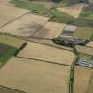
General oblique aerial view of the cropmarks of the trackway and ring ditch and Mungoswells Farm, taken from the NW. |
31/7/2009 |
Item Level |
|
 |
On-line Digital Images |
DP 083141 |
RCAHMS Aerial Photography Digital |
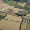
General oblique aerial view of the cropmarks of the rig, trackway and ring ditch and Mungoswells Farm, taken from the NW. |
31/7/2009 |
Item Level |
|
 |
On-line Digital Images |
DP 083142 |
RCAHMS Aerial Photography Digital |
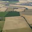
General oblique aerial view of the cropmarks of the rig, trackway and ring ditch and Mungoswells Farm, taken from the NNW. |
31/7/2009 |
Item Level |
|
 |
On-line Digital Images |
DP 083143 |
RCAHMS Aerial Photography Digital |
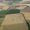
General oblique aerial view of the cropmarks of the rig, trackway and ring ditch and Mungoswells Farm, taken from the NW. |
31/7/2009 |
Item Level |
|
 |
On-line Digital Images |
SC 1644940 |
List C Survey |
View from S. |
1975 |
Item Level |
|
 |
On-line Digital Images |
SC 1644941 |
List C Survey |
View from SW. |
1975 |
Item Level |
|
 |
On-line Digital Images |
SC 2448361 |
Records of the Ordnance Survey, Southampton, Hampshire, England |
Mungoswells, NT47NE 39, Ordnance Survey index card, Recto |
1958 |
Item Level |
|


