
Pricing Change
New pricing for orders of material from this site will come into place shortly. Charges for supply of digital images, digitisation on demand, prints and licensing will be altered.
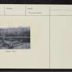
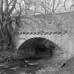
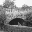
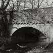
Humbie Mill Bridge


Bridge (17th Century)
Site Name Humbie Mill Bridge
Classification Bridge (17th Century)
Alternative Name(s) Humbie Water
Canmore ID 54788
Site Number NT46SE 3
NGR NT 46118 63005
Datum OSGB36 - NGR
Permalink http://canmore.org.uk/site/54788


- Council East Lothian
- Parish Humbie (East Lothian)
- Former Region Lothian
- Former District East Lothian
- Former County East Lothian
NT46SE 3 46118 63005
(NT 4611 6300) Humbie Mill Bridge (NAT)
OS 6" map (1971)
The bridge over the Humbie Water at Humbie Mill is apparently a 17th c construction. It has one segmental arch with a span of 24'4" and the roadway is 13'10" wide.
RCAHMS 1924
This bridge was rebuilt in 1934 and incorporates a date stone of 1659.
Visited by OS (WDJ) 20 September 1965 and (SFS) 6 August 1975.
Field Visit (9 April 1920)
The bridge (fig. 88) over the Humbie Water at Humbie Mill is apparently a 17th century construction. It is built of uncoursed rubble and has one segmental arch with a span of 24 feet 4 inches. The width of the soffit remains unaltered at 14 ½ feet, and the roadway is 13 feet 10 inches wide. The top of the parapet is 21 feet 2 inches above the water line. The parapets overhang and are borne on unmoulded corbels.
RCAHMS 1924, visited 9 April 1920.

