
Preston Toll


Settlement (Period Unassigned)
Site Name Preston Toll
Classification Settlement (Period Unassigned)
Canmore ID 54726
Site Number NT46NW 33
NGR NT 41199 65577
Datum OSGB36 - NGR
Permalink http://canmore.org.uk/site/54726


- Council East Lothian
- Parish Ormiston
- Former Region Lothian
- Former District East Lothian
- Former County East Lothian
NT46NW 33 NT 411199 65577
NT 412 655. Earthwork, Preston Toll: visible on aerial photographs. (Listed as a settlement by CUCAP.)
(Undated) information in NMRS.
Preston Toll. Scheduled as fort.
Information from Historic Scotland, scheduling document dated 14 October 1993.
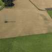
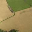
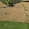
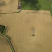
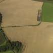
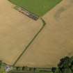
The SW half of this double ditched settlement is visible as a cropmark on vertical air photographs (OS 75/293/272-3, flown 1975).
Information from RCAHMS, 1995
Note (2 December 2015 - 18 May 2016)
This fort or fortified settlement, which is known only from cropmarks, is situated in undulating arable ground, but rather than contour symmetrically around a hillock, the defences embrace a shallow saddle or gully crossing the low ridge from NNW to SSE. Oval on plan, it measures 110m from NE to SW by 100m transversely (0.86ha) within twin ditches, and allowing for the presence of the inner rampart, the scar of which is particularly noticeable on some of the photographs on the NE, the interior extends to about 0.66ha. The ditches are set about 5m apart, the inner some 5m in breadth and the outer between 3m and 4m. There is an entrance on the ENE, but the lack of clear definition in the cropmarks in several other sectors may hide others. The interior is featureless, though the saddle probably contains relatively deep sediments preserved in the rear of the rampart on the NE.
Information from An Atlas of Hillforts of Great Britain and Ireland – 18 May 2016. Atlas of Hillforts SC3777

