
'Dere Street': Border - Newstead - Elginhaugh


Roman Road (Roman)
Site Name 'Dere Street': Border - Newstead - Elginhaugh
Classification Roman Road (Roman)
Canmore ID 54531
Site Number NT45NE 21
NGR NT 4743 5500
NGR Description NT 4743 5500 to NT 4500 5930
Datum OSGB36 - NGR
Permalink http://canmore.org.uk/site/54531


- Council Scottish Borders, The
- Parish Channelkirk
- Former Region Borders
- Former District Ettrick And Lauderdale
- Former County Berwickshire
NT45NE 21.00 from 4743 5500 to 4500 5930 RR 2.
Formerly RR8g.
NT45NE 21.01 NT 4550 5736 RR 2 Dun Law, section
NT45NE 21.02 NT 4668 5620 RR 2 Turf Law, section
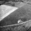
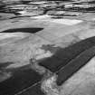
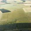
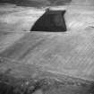
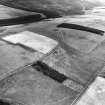
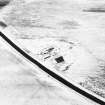
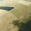
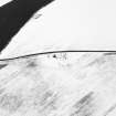
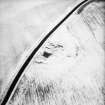
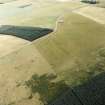
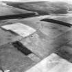
At a point just above the W corner of Glengelt Plantation, now felled (NT 472 553) the hollow tracks noted on NT45SE 52 quickly die out on the moorland NE of the stone dyke, and it can be clearly seen that the dyke is running along the Roman roadway itself - a wide, shallow terrace flanked along its upper (NE) side by a row of quarry-pits. At the point where a sheepfold is built against the SW side of the wall the road-mound can be seen inside it as the wall has here encroached eastwards over the whole of the terrace; but at this point the road changes its direction, very slightly, to a course which runs more nearly NNW and 50 yds beyond the fold the terrace has drawn clear of the wall on its NE side to a breadth of 30 ft. This direction is maintained without material change for nearly a mile, but no natural aiming-mark can be identified in either direction. Farther on the terrace increases to a maximum breadth of 55 ft, and its method of construction is interesting. Its upper edge is defined by a low scarp, accentuated by the piling-up of the overburden to form a slight ridge along its lip; the material obtained by the scarping has been formed into a road-mound with its crown sited well outside the central line of the terrace - here, in fact, about 30 ft out from the scarp. The same type of construction occurs on Dere Street not far S of the Border, on Fouplay Head, where it is clear that the reason for using this technique has been lack of solid stone for bottoming and kerbing. The outer side of the road-mound shades off into the natural slope on the outer side of the terrace.
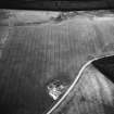
Some 500 yds from the fold the road has to pass a deep marshy hollow in which rises a small tributary of the Rauchy Burn (NT 469 557), a very large quarry bearing witness to the amount of filling that has been found necessary; the mound disappears and the terrace tapers away as the road runs down into the hollow, and everything is lost in the bottom for a distance of 115 yds.
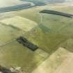
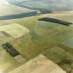
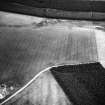
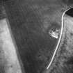
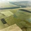
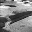
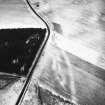
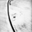
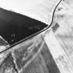
About 80 yds beyond the bottom of the hollow traces of the Roman road reappear at a point 45 yds NE of a parallel fence and just below the easternmost hollow track of the complex that represents the post-Roman route. The ground here slopes from SW to NE and it is the upper (SW) scarp of the roadway that survives; but here and for the next quarter of a mile the herbage is heavy and the remains of the road have been damaged by surface drainage, with the result that the line is extremely difficult to follow. After passing a large quarry-pit, sunk in a low knoll which just breaks the even surface of the moorland, the road becomes more definitely recognisable as a terrace, and after a break at the head of the Windycleuch Burn (NT 466 564, about 100 yds NE of the fence) it can again be followed with decreasing difficulty until, after passing a large group of quarries in another and more extensive knoll, it begins to appear quite clearly as an almost flat terrace with an upper and a lower scarp. Such traces of the road-mound as survive lie well outside the central line, and the whole is up to 45 ft in breadth. Quarry-pits occur by the roadside from place to place, and a group of several is to be seen near the head of a marshy sike by which the road is interrupted shortly before reaching the watershed. The straight line, which has been held without appreciable deflection all the way from the sheepfold near Glengelt Plantation (NT 470 554), continues for about 190 yds beyond the transverse fence that marks the watershed (NT 464 567, and 1280 ft OD), its alignment being on the high ground at Soutra Aisle, now in view, where there is, however, no natural aiming-mark; here (NT 462 569) it turns some 26 degrees to the left, in a curve measuring about 70 yds along its arc, and then settles down on a fresh alignment, which it holds for about 650 yds, to the spot chosen for the crossing of a burn to be mentioned shortly. Indeed, the diversion made at the crossing-place is so slight that the same line might virtually be considered to continue for a further distance of some 330 yds to where the road reaches the top of a low spur of Dun Law. A section measured just NW of the curve gave the whole roadway an overall breadth of 61 ft, divided as follows from SW to NE: upper scarp, with debris accumulated at its foot, 13 ft, falling 2 ft 6 in from the top of the bank of piled-up overburden; flat terrace, 15 ft; road-mound, 21 ft, rising 1 ft in the centre above the level of the terrace; quarry-ditch, 12 ft, its bottom 3 ft below the crown of the road-mound. This quarry-ditch has not been noted previously and may perhaps have been made use of here on acccount of the slightness of the transverse slope. From the point where the alignment changes, the road gradually descends a small valley which separates the shoulder on which it lies from Dun Law. There is little to remark here, as the constructional features, so well preserved higher up, progressively lose their identity at the lower levels as the soil becomes softer and deeper. On reaching the bottom of the valley the road is broken by the small burn that was mentioned above; no actual remains can be seen for some distance back from the actual crossing-place (NT 454 572), and appearances suggest that flood-water has covered and washed out the lowermost 50 yds. This effect may well have been accentuated by a broken bridge, as the crossing-place shows rocks and a low clay cliff such as would have necessitated a bridge. There is a conspicuous group of small quarry-pits here on the right bank of the burn. Beyond the crossing another good example can be seen of terrace-and-mound construction; the whole terrace is here up to 50 ft broad over all, and quarry-pits, which appear rather sparsely along its upper margin, probably represent subsequent repairs. About midway between the unnamed burn and the Armit Water the road curves to the N by means of two obtuse angles with a straight leg between them 55 yds in length. A large quarry-pit and some small ones appear where this change of direction is made. As the road descends to the Armet Water it is cut into by the tracks of the later road; as a result of this, and erosion, the Roman work becomes difficult to identify; in places nothing but the upper scarp can be seen, accompanied by quarry-pits. On the N side of the Armet Water, the agger can be seen mounting the steep slope for some 75m, before entering a shallow cutting where it is obliterated by hollow tracks of more recent date. The principal track continues N as a terrace, with a series of quarry-pits on the W, suggesting that the Roman road followed this line as far as the fence enclosing Beatman's Acre (NT 4527 5804). Thereafter the later track curves past Soutra Aisle and descends towards the Dean Burn (NT 448 595) in a series of braided hollows. Quarry-pits seen by RCAHMS in 1937 to the N of Soutra Aisle no longer survive.
RCAHMS 1956.
NT 4743 5500 - NT 4727 5511 No trace. (JTT)
NT 4727 5511 - NT 4713 5535 Hollow-ways (JD, SFS)
NT 4713 5535 - NT 4692 5574 Extant; quarry-pits noted between NT 4707 5544 and NT 4702 5552. (JD, SFS)
NT 4692 5574 - NT 4668 5619 Traces of road, but too indistinct for survey. (JTT)
NT 4668 5619 - NT 4639 5670 Slight terrace. (SFS)
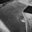
NT 4639 5670 - NT 4626 5691 Prominent terrace. (SFS)
NT 4626 5691 - NT 4598 5706 Road mound visible. (SFS)
NT 4598 5706 - NT 4542 5750 Numerous hollow-ways. (SFS)
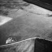
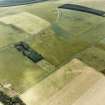
NT 4542 5750 - NT 4527 5804 Hollow-ways, terraces, mounds and quarry-pits along course but too confused for survey. (JTT)
NT 4527 5804 - NT 4527 5824 Faint indications of road and quarry-pits in arable field. (JTT)
NT 4527 5824 - NT 4523 5867 No trace. (JTT)
NT 4523 5867 - NT 4517 5884 Terrace and hollow approximately on line of road as published on OS 6-inch map, but no definite surveyable feature. (JTT)
NT 4517 5884 - NT 4500 5930 No trace. (JTT) (SFS notes a distinct soilmark, 3m wide, on a different line, from NT 4523 5867 to NT 4500 5930.)
Visited by OS (JD) May 1955; (JTT) December 1964; (SFS) April 1975.
Sbc Note
Visibility: This is an upstanding earthwork or monument.
Information from Scottish Borders Council

