
Stow, Church Wynd, Bishop's Palace


Manor House (Medieval)
Site Name Stow, Church Wynd, Bishop's Palace
Classification Manor House (Medieval)
Canmore ID 54522
Site Number NT44SE 5
NGR NT 45980 44540
Datum OSGB36 - NGR
Permalink http://canmore.org.uk/site/54522


- Council Scottish Borders, The
- Parish Stow
- Former Region Borders
- Former District Ettrick And Lauderdale
- Former County Midlothian
NT44SE 5 45980 44540
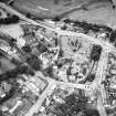
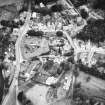
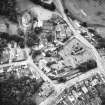
(NT 4597 4453) Bishop's Palace (NR) (In Ruins)
OS 6" map (1908)
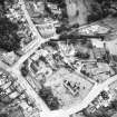
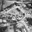
This ruin is known locally as the 'Bishop's Palace'. It was an oblong structure of three storeys and a garret, 49 3/4ft by 20 1/2ft over rubble walls 2ft 4ins thick. The gables are fairly complete, but most of the lateral walls have been destroyed. It dates from the late 15th or early 16th century.
Within a yard of the manse are traces of foundations and a circular depression, stated to have been a well, possibly in connection with the "Bishop's Palace" (Wilson notes the "Bishop's Well" as very likely the well from which the old Catholic clergy obtained their water).
T Wilson 1924; RCAHMS 1929, visited 1915.
A project was set up in July 1984 to excavate the ruins of the Bishop's Palace at Stow, a manor house of the Bishops of St Andrews. This has uncovered the layout of a 17th Century building, which was altered on at least two occasions. In its second phase the ground floor of this three storey structure was divided into two rooms, but possible in its first phase the building formed a domestic wing attached to one end of a hall. If so this has been removed by about the end of the 17th Century when the dividing wall of phase two was constructed. This consisted of clay with a facing of stone and plaster. The western room of the house was sub-divided near the end of its life, probably for the housing of livestock. The house was demolished and its ground floor filled with rubble and domestic rubbish in the early 19th Century. There is some evidence for destruction by fire. In front of the house was an enclosed cobbled yard, underneath which was a broad ditch which may have been the old boundary of the Bishop's manor. This site is to be laid out for public viewing.
P J Dixon 1985.
Field Visit (1982 - 1988)
The Manpower Services Commission funded Border Burghs Archaeology project (sponsored by Borders Architects Group) carried out excavations in the burghs of the region, created the Sites and Monuments Record for Borders Region and carried out field survey in support, including plane table surveys of selected sites under the direction of Dr Piers Dixon.
Sbc Note
Visibility: This site has been excavated.
Information from Scottish Borders Council

