
Caddonlee


Enclosure (Period Unassigned)
Site Name Caddonlee
Classification Enclosure (Period Unassigned)
Canmore ID 54393
Site Number NT43NW 15
NGR NT 4445 3530
Datum OSGB36 - NGR
Permalink http://canmore.org.uk/site/54393


- Council Scottish Borders, The
- Parish Caddonfoot
- Former Region Borders
- Former District Ettrick And Lauderdale
- Former County Selkirkshire
NT43NW 15 444 353.
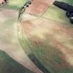
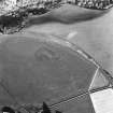
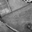
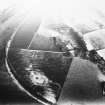
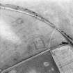
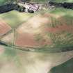
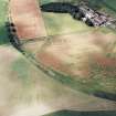
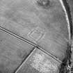
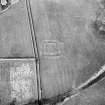
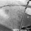
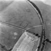
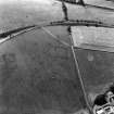
NT 444 353. Enclosure, Caddonlee: visible on air photographs.
NY 4447 3531. Vestiges of a square, ditched enclosure with an annexe on its E side are situated on level, regularly ploughed, arable ground at Caddonlee farm. It is 44.0 m by 42.0 m and the annexe is 18.0 m wide. The ditch, which has been spread by ploughing, is up to 6.4 m wide and 0.2 m deep; there appears to have been a causewayed entrance on the E side of the main work. There is no evidence of an upcast bank.
The site is thought locally to have been a penning; however, its origin and purpose cannot be ascertained from the remaining ground evidence. Course of ditches surveyed at 1:2500.
Visited by OS (MJF) 1 December 1979
Additional aerial photographs taken by the RCAHMS in 1980.
Sbc Note
Visibility: This site is visible as a cropmark.
Information from Scottish Borders Council

