
Pricing Change
New pricing for orders of material from this site will come into place shortly. Charges for supply of digital images, digitisation on demand, prints and licensing will be altered.
Galashiels


Tolbooth (Period Unassigned)
Site Name Galashiels
Classification Tolbooth (Period Unassigned)
Canmore ID 54354
Site Number NT43NE 20
NGR NT 4950 3575
Datum OSGB36 - NGR
Permalink http://canmore.org.uk/site/54354


- Council Scottish Borders, The
- Parish Galashiels
- Former Region Borders
- Former District Ettrick And Lauderdale
- Former County Selkirkshire
NT43NE 20 4950 3575.
(Area NT 492357) The remains of the tolbooth of Galashiels, built about 1599, stood within the gates of the policies of Gala House, until 1880 when they were domolished.
A Jeffrey 1864; T Craig-Brown 1886
The Tolbooth would have been erected as soon "as possible" after the Galashiels charter of 1617. The ruin stood near the Old Town Cross (NT43NE 17) but it was removed in 1880 because it projected into Scott Crescent and had become dangerous.
W Rutherford 1930
The site of the tolbooth is deduced from Rutherford's description to have been at approx NT 49503575. Its site cannot be traced on the ground, nor was it indicated by Wood on his 1824 plan. (J Wood 1824)
Visited by OS (TRG) 4 March 1977
Sbc Note (21 March 2016)
Visibility: This was the site of an archaeological monument, which may no longer be visible.
Information from Scottish Borders Council
Previously also listed under duplicate site NT96SW 510 -CANCELLED. HES (LCK) 11.6.2024
Standing Building Recording
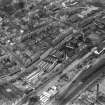
NT 4940 3580 A large yard and a group of buildings on the S side of Huddersfield Street in Galashiels were to be
removed during construction of the Galashiels Inner Ring Road. Archaeological work from 5–16 March 2007 consisted of a comprehensive survey of the standing buildings at the Burgh Council Yard, including research, photographic and metric survey, and descriptive and analytical discussion. The buildings include two groups, one related to the Waverley Iron Works and Textile Mill which occupied the N site on Huddersfield Street and the other a council-owned group for refuse collection and incineration. The mill group dates from the early to the later 19th century and included workshops, an engine and boilerhouse and other finishing buildings, at some time associated with Aimers and McLean, engineers. The well finished and proportioned council buildings are early 20th-century and include a refuse destructor, stable and a carter’s house. We excavated 11 trenches were excavated in the compound. No features of archaeological significance were identified, either predating the current building complex or indicative of features and structures associated with
the mill.
Archive to be deposited with RCAHMS. Report deposited with RCAHMS.
Funder: Scottish Borders Council.

