
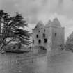
Newark Castle


Tower House (Medieval)
Site Name Newark Castle
Classification Tower House (Medieval)
Alternative Name(s) Selkirk, New Werk
Canmore ID 54273
Site Number NT42NW 1
NGR NT 42079 29395
Datum OSGB36 - NGR
Permalink http://canmore.org.uk/site/54273


First 100 images shown. See the Collections panel (below) for a link to all digital images.
- Council Scottish Borders, The
- Parish Selkirk
- Former Region Borders
- Former District Ettrick And Lauderdale
- Former County Selkirkshire
NT42NW 1 42079 29395
(NT 4208 2939) Newark Castle (NR) (Remains of)
OS 6" map (1957).
For (unlocated) predecessor tower, see NT42NW 14.
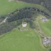
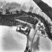
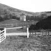
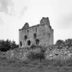
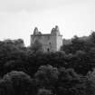
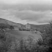
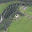
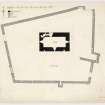
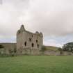
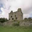
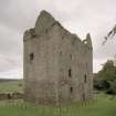
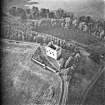
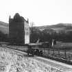
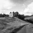
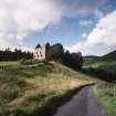
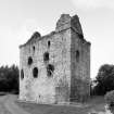
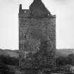
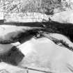
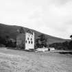
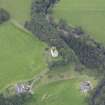
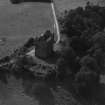
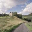
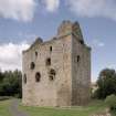
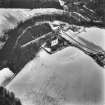
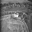
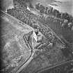
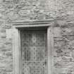
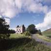
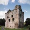
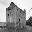
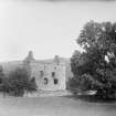
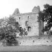
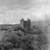
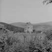
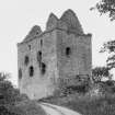
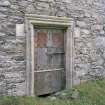
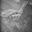
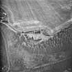
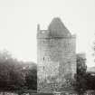
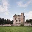
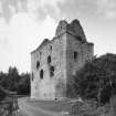
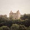
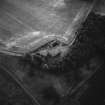
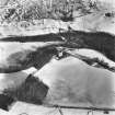
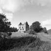
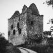
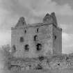
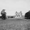
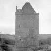
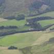
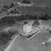
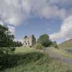
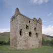
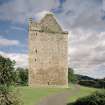
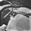
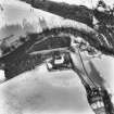
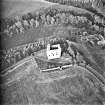
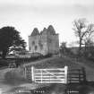
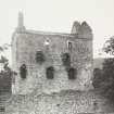
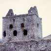
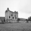
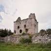
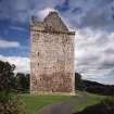
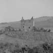
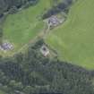
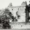
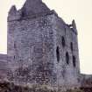
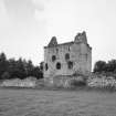
Newark Castle: 'The Newark' or 'New Werk' comes on record for the first time in 1423; it was so called to distinguish it from an older castle (NT42NW 14). The existing castle, which occupies a naturally strong situation, is a massive oblong tower-house, standing within a barmkin. The Barmkin: In the first instance the entire summit of the knoll was probably enclosed; the existing barmkin, however, is withdrawn about 100 ft from its S edge. In its present form it is not earlier than the 16th century. It is quadrangular, measuring 165ft from N to S by 202ft transversely; the rubble wall averages 5ft in thickness and stands to a greatest height of 11ft near the SE corner. On N and W it is greatly reduced, some parts being fragmentary. Except on the N, where further protection was unnecessary, a small rectangular tower projects from each side of the enclosure. Of the one to the W, which formed the entrance to the enclosure, only a vestige survives; the others are better preserved. Numerous 16th century gun-loops may be seen in the walling. Within the NE corner of the enclosure there are slight traces of an outbuilding, and there is evidence that a large, lofty addition stood against the E gable of the tower. These may be the structures built by John de Moravia in 1473.
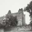
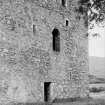
The tower stands in the centre of the enclosure. About the middle of the 18th century it was unroofed and much of the accessible face-work was removed. In the 19th century, however, most of the damage was roughly repaired and the fabric is still comparatively sound. Oblong on plan (q.v.) and measuring externally 64ft 10 ins by 40ft it rises to five storeys and a garret. The roof has fallen in, as have the upper floors. The masonry is in general roughly built of random rubble with freestone dressings, and was originally harled. Up to the level of the first floor the external walls seem to be mainly of the early 15th century; from that level to the wall-head they are probably to be dated to 1467, when extensive repairs were carried out. Tranter suggests that the cap-houses at the NW and SE angles are of 16th century date.
In 1547-8 the place was beseiged by the English under Lord Gray of Wilton, who entered the "barbacanne" and burnt the stables but found the house not "pregnable" without ordnance. None the less, it was burnt in the following year.
Some minor alterations were made on the tower in the last quarter of the 17th century.
RCAHMS 1957, visited 1946; N Tranter 1962; A M T Maxwell-Irving 1974.
Newark Castle and barmkin are as decribed by the RCAHMS. No trace of an outbuilding could be found within the NE corner of the latter.
Visited by OS (RD), 31 January 1966.
No change to the previous information.
Visited by OS (MJF), 15 December 1979.
Sbc Note
Visibility: Upstanding structure, which may not be intact.
Information from Scottish Borders Council.

