Scheduled Maintenance
Please be advised that this website will undergo scheduled maintenance on the following dates: •
Tuesday 12th November from 11:00-15:00 & Thursday 14th November from 11:00-15:00
During these times, some services may be temporarily unavailable. We apologise for any inconvenience this may cause.
Hawkhass Linn
Earthwork (Period Unassigned)
Site Name Hawkhass Linn
Classification Earthwork (Period Unassigned)
Alternative Name(s) Hawkhass House; Langside Burn
Canmore ID 54103
Site Number NT40SE 4
NGR NT 4931 0286
Datum OSGB36 - NGR
Permalink http://canmore.org.uk/site/54103
- Council Scottish Borders, The
- Parish Cavers
- Former Region Borders
- Former District Roxburgh
- Former County Roxburghshire
NT40SE 4 4931 0286
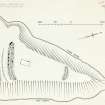
Earthwork, Hawkhass Linn. This earthwork is situated at a height of just over 1000 ft. OD on the top of a narrow elongated promontory formed by the confluence of the Fore and Mid Burns, which unite here to form the Langside Burn. The position is well suited for defence since at this point both burns flow in steep-sided ravines some 50 ft. deep, and the only easy access to the promontory is across level ground from the SSW. This approach has been blocked by double ramparts and ditches, leaving only a narrow entrance at the W end, while a short single rampart has been drawn across the apex where the ground falls gently to the watersmeet. It is probable that the inner rampart was originally continuous, but no trace of it is now visible along either edge of the promontory.
Internally the earthwork measures 160 ft. by 70 ft. along the axes. At the SSW end the inner rampart, which still stands to a height of 5 ft., has consisted of a boulder-faced rubble wall 15 ft thick: two courses of stones are visible at one point on the exterior and it is probable that several more courses are buried beneath the debris. The other two surviving ramparts were probably of similar construction, but both are reduced to a height of 2 ft. and neither shows any sign of stonework at the present time. Both the ditches average 14 ft. in width, the innermost being 3 ft. deep and the outermost not more than 1 ft. deep. Within the interior there are slight traces of a rectangular building with a stone foundation measuring 30 ft. by 15 ft. over all.
RCAHMS 1956, visited 1949
As the situation of this earthwork is comparable with that of Lintalee (RCAHMS 1956, No.438) it may likewise be of mediaeval origin.
(i) MISCELLANEOUS EARTHWORKS In the absence of excavation, over eighty earthworks in the county cannot be classified either because they do not conform to recognised types or because their plans are not sufficiently distinctive. A few of these, occupying commanding positions on hilltops or the crests of ridges, are unlikely to be later than the 11th century; such are Bonchester Hill (No. 278), the group of earthworks on Whitcastle Hill (No. 865), and five roughly D-shaped earthworks lying within a radius of two miles between the River Teviot and the Slitrig Water- Gray Hill 2 (No. 999), Birny Knowe (No. 995), Crom Rig (No. 1000), Dodburn (No. 160, ii), and Pen Sike (No. 168)- which are characterised by ramparts massive in proportion to their size. The majority, however, are situated on hillsides or in the bottoms of valleys, generally below the 800 ft. contour, and are probably mediaeval. Most of these lower-lying structures, of which the outstanding examples are Timpendean (No. 435), Iron Castle (No. 945), and Scraesburgh (No. 466), were evidently designed for habitation and presumably contained wooden buildings; but a few of the simpler earthworks such as Huntly Burn (No. 51) may have been enclosures for stock.
RCAHMS 1956.
The comparison with Lintalee (No.438) is rather fine drawn. The overall width of the Lintalee earthworks is approx. 260ft., of Hawkhass Linn 60 ft. with the reasonable suggestion in the text that..."it is probable that the inner rampart was originally continuous"...
The two sets of earthworks, are quite different, those at Hawkhass Linn being of normal rampart and ditch (boulder faced, rubble cored) construction, as against the widely spaced banks and single outer ditch separated by a wide berm at Lintalee. Although it is not necessarily significant, Lintalee is at 300 ft. OD, Hawkhass Linn is above 1000ft OD.
Information from OS, 27 November 1957.
Earthwork as described by RCAHMS.
Visited by OS (WDJ), 27 September 1960.
Note (6 August 2015 - 31 May 2016)
This small fortification is situated on a promontory formed between two steep-sided burn gullies that converge in the valley between Maiden Paps and Carry Edge. The only easy approach is from the SW and is blocked by two ramparts with external ditches, while access up the gently shelving slope from the confluence of the burns on the NE is barred by a single rampart. The interior measures about 50m from NE to SW and tapers from 30m transversely on the SW to 20m on the NE (0.13ha). The inner rampart, now forming a bank 1.5m in height, has been a boulder-faced wall 4.5m in thickness, while both the ditches are in the order of 4m in breadth by 0.9m in depth. The defences on the SW terminate short of the NW margin of the promontory, presumably indicating the position of the entrance on the WSW. The only feature visible within the interior are the footings of a rectangular building.
Information from An Atlas of Hillforts of Great Britain and Ireland – 31 May 2016. Atlas of Hillforts SC3265
Sbc Note
Visibility: This is an upstanding earthwork or monument.
Information from Scottish Borders Council


