Accessibility

Font Size

100% 150% 200%

Background Colour

Default Contrast
Close Reset

East Field, Inveresk

Field Boundary(S) (Period Unknown), Palisaded Settlement (Prehistoric), Pit(S) (Prehistoric), Rig And Furrow (Medieval) - (Post Medieval), Ring Ditch(S) (Prehistoric), Roundhouse(S) (Prehistoric)

Site Name East Field, Inveresk

Classification Field Boundary(S) (Period Unknown), Palisaded Settlement (Prehistoric), Pit(S) (Prehistoric), Rig And Furrow (Medieval) - (Post Medieval), Ring Ditch(S) (Prehistoric), Roundhouse(S) (Prehistoric)

Alternative Name(s) Eastfield; Old Craighall

Canmore ID 53907

Site Number NT37SW 69

NGR NT 34229 70337

NGR Description NT centred on 34229 70337

Datum OSGB36 - NGR

Permalink http://canmore.org.uk/site/53907

Ordnance Survey licence number AC0000807262. All rights reserved.
Canmore Disclaimer. © Bluesky International Limited 2025. Public Sector Viewing Terms

Toggle Aerial | View on large map

Digital Images

Eastfield, Inveresk: oblique air photograph of pit-alignment, enclosure, cultivation remains and cropmarks
Eastfield, Inveresk: oblique air photograph of pit-alignment, enclosure, cultivation remains and cropmarksEastfield, Inveresk: oblique air photograph of pit-alignment, enclosure, cultivation remains and cropmarksEastfield, Inveresk: oblique air photograph of pit-alignment, enclosure, cultivation remains and cropmarksEastfield, Inveresk: oblique air photograph of pit-alignment, enclosure, cultivation remains and cropmarksEast Field, Inveresk: oblique air photograph of enclosure, cropmarks, culitvation remains and pit alignment.East Field, Inveresk, oblique aerial view, taken from the NW, centred on the cropmarks of a pair of parallel pit-alignments, an enclosure and cultivation remains. Cropmarks of a pit-alignment and pits are visible in the top 
half of the photograph.Oblique aerial view centred on the cropmarks of the palisaded enclosure, cropmarks, cultivation remains and possible ring-ditches, taken from the WNW.Oblique aerial view.East Field, Inveresk: oblique air photograph of pit-alignment, enclosure, cropmarks and cultivation  remainsEast Field, Inveresk: oblique air photograph of enclosure, cropmarks, cultivation remains and pit alignment.East Field, Inveresk, NT37SW 69, Ordnance Survey index card, page number 2, RectoEast Field, Inveresk, oblique aerial view, taken from the SE, centred on a series of cropmarks including a pit alignment.East Field, Inveresk, oblique aerial view, taken from the NW, centred on a series of cropmarks.East Field, Inveresk: oblique air photograph of pit-alignment, enclosure, cultivation remains and cropmarksOblique aerial view.Eastfield, Inveresk: oblique air photograph of pit-alignment, enclosure and possible ring-ditchesEast Field, Inveresk and Castlesteads: oblique air photograph of pit-alignments, enclosure, cultivation remains and cropmarksEast Field, Inveresk and Castlesteads: oblique air photograph of pit-alignments, enclosures, homestead, cultivation remains and cropmarksEast Field, Inveresk: oblique air photograph of pit-alignment, enclosure, cropmarks and cultivation  remainsOblique aerial view.East Field, Inveresk, oblique aerial view, taken from the SE, centred on the cropmarks of a pit-alignment and pits. A pair of parallel pit-alignments and further cropmarks are visible in the centre left of the photograph.Eastfield, Inveresk: oblique air photograph of pit-alignment, enclosure, cultivation remains and cropmarksEast Field, Inveresk and Castlesteads: oblique air photograph of pit-alignments, enclosure, homestead, cultivation remains and cropmarksOblique aerial view.East Field, Inveresk, oblique aerial view, taken from the N, centred on a series of cropmarks and showing pit alignments in the top left-hand corner and centre right of the photograph.Eastfield, Inveresk: oblique air photograph of pit-alignment, enclosure, cultivation remains and cropmarksEastfield, Inveresk: oblique air photograph of pit-alignment, enclosure, cultivation remains and cropmarksEastfield, Inveresk: oblique air photograph of pit-alignment, enclosure, cultivation remains and cropmarksEast Field, Inveresk: oblique air photograph of pit-alignment, enclosure, cultivation remains and cropmarksEast Field, Inveresk: oblique air photograph of pit-alignment, enclosure, cropmarks and cultivation  remainsEast Field, Inveresk: oblique air photograph of pit-alignment, enclosure, cropmarks and cultivation  remainsEast Field, Inveresk, oblique aerial view, taken from the NW, centred on a series of cropmarks and showing a pit alignment in the centre right of the photograph.Oblique aerial view centred on the cropmarks of the pit-alignment and palisaded settlement, taken from the NW.Oblique aerial view centred on the cropmarks of the palisaded settlement, roundhouses and pit-alignment, taken from the W.Oblique aerial view.East Field, Inveresk: oblique air photograph of pit-alignments, homestead, enclosure and cultivation remainsEast Field, Inveresk and Castlesteads: oblique air photograph of pit-alignments, enclosure, cultivation remains and cropmarksEast Field, Inveresk, NT37SW 69, Ordnance Survey index card, page number 1, RectoEast Field, Inveresk, oblique aerial view, taken from the SW, centred on a series of cropmarks and showing a pit alignment in the centre right of the photograph.East Field, Inveresk, oblique aerial view, taken from the ESE, centred on a series of cropmarks including a pit alignment.Eastfield, Inveresk: oblique air photograph of pit-alignment, enclosure, cultivation remains and cropmarksEast Field, Inveresk: oblique air photograph of pit-alignment, enclosure, cultivation remains and cropmarksEast Field, Inveresk: oblique air photograph of pit-alignments, homestead, enclosures, cropmarks and cultivation remainsOblique aerial view centred on the cropmarks of the palisaded enclosure, cropmarks, cultivation remains and possible ring-ditches, taken from the W.East Field, Inveresk: oblique air photograph of pit-alignment, enclosure, cropmarks and cultivation  remainsOblique aerial viewEast Field, Inveresk: oblique air photograph of enclosure, cropmarks, cultivation remains and pit alignment.East Field, Inveresk: oblique air photograph of pit-alignment, enclosure, cropmarks and cultivation  remainsOblique aerial view centred on the cropmarks of the palisaded enclosure, cropmarks, cultivation remains and possible ring-ditches, taken from the WSW.East Field, Inveresk, NT37SW 69, Ordnance Survey index card, RectoEast Field, Inveresk: oblique air photograph of pit-alignment, enclosure, cultivation remains and cropmarksEast Field, Inveresk: oblique air photograph of pit-alignment, enclosure, cropmarks and cultivation  remainsEast Field, Inveresk, oblique aerial view, taken from the NW, centred on the cropmarks of a pair of parallel pit-alignments, an enclosure and cultivation remains. Cropmarks of a pit-alignment and pits are visible in the top 
half of the photograph.East Field, Inveresk, oblique aerial view, taken from the N, centred on the cropmarks of a pair of parallel pit-alignments, an enclosure and cultivation remains. Cropmarks of further pits are visible in the top half of the photograph.Oblique aerial view centred on the cropmarks of the pit-alignment and palisaded settlement, taken from the SW.Oblique aerial view centred on the cropmarks of the palisaded settlement, roundhouses and pit-alignment, taken from the NW.Oblique aerial view centred on the cropmarks of the palisaded enclosure, cropmarks, cultivation remains and possible ring-ditches, taken from the SSW.Oblique aerial view.Oblique aerial view.East Field, Inveresk and Castlesteads: oblique air photograph of pit-alignments, enclosure, cultivation remains and cropmarksEast Field, Inveresk: oblique air photograph of pit-alignment, enclosure, cropmarks and cultivation  remainsEast Field, Inveresk, NT37SW 69, Ordnance Survey index card, page number 1, Recto

Administrative Areas

  • Council East Lothian
  • Parish Inveresk (East Lothian)
  • Former Region Lothian
  • Former District East Lothian
  • Former County Midlothian

Archaeology Notes

NT37SW 69 NT 34229 70337

See also NT37SW 23 and NT37SW 70 -6, 178-9 and 187.

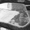
NT 342 703. Enclosure 4, East Field, Inveresk: visible on aerial photographs.

(Undated) information in NMRS.

There is nothing visible on the ground.

Visited by OS (BS) 15 August 1975

?Homestead.

(Undated) information in NMRS.

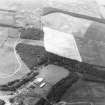
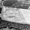
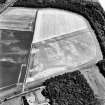
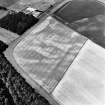
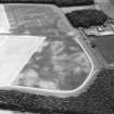
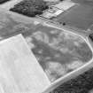
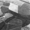
This oval palisaded settlement has been recorded as cropmarks during aerial survey from 1977 onwards. It is located on gently sloping ground above and to the NW of the River Esk, about 700m to the E of Old Craighall, in an area with extensive cropmark evidence for rig cultivation. The settlement measures about 46m from NE to SW by up to 54m transversely within a narrow ditch, which probably supported a palisade. The nature of the cropmarks makes the position of the entrance uncertain, but it may have lain on the N arc. While there are no clear indications of buildings within the settlement, macular cropmarking suggests the presence of at least two roundhouses. Recent aerial reconnaissance (RCAHMSAP 2003) has revealed the cropmarks of at least two possible ring-ditches and additional evidence for rig cultivation immediately to the NNW of the settlement.

Information from RCAHMS (MMB) 16 May 2004

A palisaded settlement, roundhouses, pits and rig have been recorded as cropmarks on oblique aerial photography (RCAHMSAP 1977, 1979, 1981, 1986, 1992, 1994, 1995, 1996, 2000) on level ground about 230m NNE of Smeaton (NT37SW 713). The palisaded settlement is oval in plan measuring about 45m to 50m across. What may be a roundhouse about 8m in diameter lies within the E side of the settlement. There is rig, a scatter of pits and further roundhouses to the N and W of the settlement. Two pit-alignments (NT37SW 70 and NT37SW 207 ) extend across the field to the W of the settlement.

Information from RCAHMS (KMM) 20 May 2004.

Site identified during an archaeological assessement carried out by CFA Archaeology Ltd.

Mhairi Hastie, 2006.

Field boundaries have been recorded as cropmarks on oblique aerial photography (RCAHMSAP 1979, 1992) extending from NT 3404 7044 to NT 3421 7034 and from NT 3401 7027 to NT 3422 7033. The latter boundary continues in to the adjacent field to the W.

Information from RCAHMS (BN) 5 May 2008

Activities

Aerial Photographic Transcription (1 April 2004 - 3 April 2004)

An aerial transcription was produced from oblique aerial photographs. Information from Historic Environment Scotland (BM) 31 March 2017.

References

MyCanmore Image Contributions


Contribute an Image

MyCanmore Text Contributions