
Pricing Change
New pricing for orders of material from this site will come into place shortly. Charges for supply of digital images, digitisation on demand, prints and licensing will be altered.
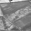
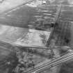
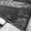
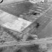
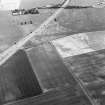
Howe Mire


Field Boundary(S) (Period Unknown)
Site Name Howe Mire
Classification Field Boundary(S) (Period Unknown)
Canmore ID 53696
Site Number NT37SE 52
NGR NT 35352 71550
Datum OSGB36 - NGR
Permalink http://canmore.org.uk/site/53696


- Council East Lothian
- Parish Inveresk (East Lothian)
- Former Region Lothian
- Former District East Lothian
- Former County Midlothian
NT37SE 52 NT 35352 71550
Ploughed out field bounadries have been recorded as cropmarks (RCAHMSAP 1976).
Information from RCAHMS (DCC) 7 February 2007

