
Prestonpans, Johnnie Cope's Road, Bankton House


Country House (17th Century)
Site Name Prestonpans, Johnnie Cope's Road, Bankton House
Classification Country House (17th Century)
Alternative Name(s) Colonel Gardiner's House
Canmore ID 53686
Site Number NT37SE 43
NGR NT 39506 73688
Datum OSGB36 - NGR
Permalink http://canmore.org.uk/site/53686


- Council East Lothian
- Parish Prestonpans
- Former Region Lothian
- Former District East Lothian
- Former County East Lothian
NT37SE 43 39506 73688.
(NT 39506 73688) Bankton (NAT) (Formerly Col Gardiner's House) (NAT)
OS 6" map (1966)
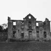
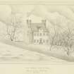
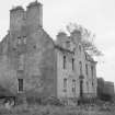
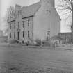
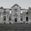
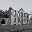
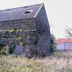
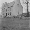
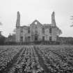
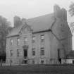
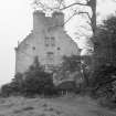
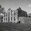
Bankton House, which was formerly owned by Col Gardiner who was killed in the Battle of Prestonpans (1745), is a late 17th century mansion. It is oblong on plan and contains 3 storeys beneath the wall head; within the roof were 2 garret storeys.
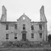
Originally known as Olivstob, Bankton was purchased by Col. Gardiner from one of the Hamiltons. It was afterwards owned by Andrew Macdowall, Lord Bankton. Burnt down in 1852, it was restored and is still in use as a farmhouse.
RCAHMS 1924, visited 1920
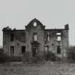
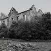
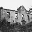
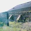
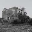
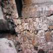
Bankton (name confirmed) is now a non-impressive ruin.
Visited by OS (JP) 21 October 1971
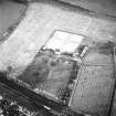
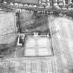
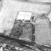
NT 393 737 An archive assessment, metal detector survey and watching brief were carried out in advance of, and during, the construction of a horse riding arena in a paddock at Bankton House, Tranent. The project confirmed that no archaeologically significant finds or features exist within the application area.
Sponsor: Mr Richard MacKenzie
Ross White, 2007.
NT37SE 43.00 39506 73688
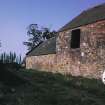
NT37SE 90 39468 73662 Dovecot, Garden House
NMRS REFERENCE:
Bankton House which was Category A Listed was gutted by fire 31/05/1966. Information from Demolitions catalogue held in RCAHMS Library.
EXTERNAL REFERENCE
Edinburgh Central Library:
Edinburgh Central Library: Doddridge P., 'Life of Colonel James Gardiner' 1747. London, Religious Tract Society. (Son of Patrick Gardiner of Torwood Head and Mary Hodge of Gladsmuir. Born Carriden 10 January 1687/88. Died (killed) 21 September 1745 aged 57 at the Battle of Prestonpans.
Field Visit (23 March 1920)
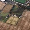
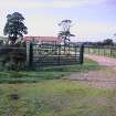
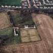
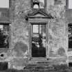
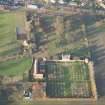
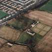
Bankton House, better known perhaps as ‘Colonel Gardiner's House’ from its ill-fated owner who fell at the Battle of Prestonpans (1745), is a late 17th century mansion (fig. 20 [SC 1126871]) standing in a park rather less than a quarter of a mile south-east of Prestonpans station. It is oblong on plan and contains three storeys beneath the wall head; within the roof were two garret storeys. The high pitched gables are curved geometrically. The basement storey is partly sunk, so that the pedimented entrance at first floor level is reached from a flight of steps which crosses a ‘dry area’. To the south lies a large walled garden, now under plough, with a square Belvidere or garden house at either end of the north wall.
Bankton House was originally known as Olivstob and was purchased by Col. Gardiner from one of the Hamiltons. It was afterwards owned by Andrew Macdowall, Lord Bankton. In 1852 it was destroyed by fire, but wasr estored and is still in use as a farmhouse.
RCAHMS 1924, visited 23 March 1920.
Desk Based Assessment (June 2007)
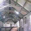
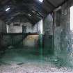
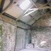
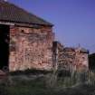
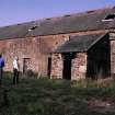
An enhanced desk-based assessment was carried out by CFA Archaeology Ltd (CFA) in June 2007 on the historical development of Bankton House Steading, Prestonpans, East Lothian (NGR: NT 39452 73651 Fig 1). The work was commissioned by Ginger Development Ltd to fulfil a planning condition based on a Written Scheme of Investigation for archaeological work approved by East Lothian Council’s Heritage Officer.
The original planning condition required a desk-based assessment followed by a Standing Building survey, but unauthorised development work took place before the archaeological work could be undertaken. The archaeological condition was therefore modified and an enhanced desk-based assessment was carried out, together with a site visit to record any surviving features of the former steading.
Metal Detector Survey (September 2009)
NT 3950 7368 A metal detector survey and watching brief were carried out in September 2009 during the construction of a septic tank. No archaeologically significant finds or remains were discovered.
Archive: RCAHMS (intended). Reports: RCAHMS and SMR
Funder: East Lothian Council
Stuart Mitchell - CFA Archaeology Ltd

