Scheduled Maintenance
Please be advised that this website will undergo scheduled maintenance on the following dates: •
Tuesday 3rd December 11:00-15:00
During these times, some services may be temporarily unavailable. We apologise for any inconvenience this may cause.
Sheriffhall Dovecot
Dovecot (17th Century)
Site Name Sheriffhall Dovecot
Classification Dovecot (17th Century)
Alternative Name(s) Sheriffhall Doocot; Sheriffhall Doo'cot; Sheriffhall House
Canmore ID 53490
Site Number NT36NW 6.01
NGR NT 32047 67924
Datum OSGB36 - NGR
Permalink http://canmore.org.uk/site/53490
- Council Midlothian
- Parish Newton
- Former Region Lothian
- Former District Midlothian
- Former County Midlothian
NT36NW 6 3204 6792
See also NT36NW 124.
(NT 3204 6792) Dovecot (NR)
OS 6" map (1968)
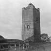
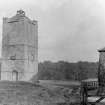
The late 16th- or early 17th c house of Sheriffhall has been demolished, but the stair wing remains and is used as a dovecot. It is a square rubble-built structure, measuring externally 12'9" each way. The original entrance has been built up. There are gun-loops to S and E at first floor level.
The lands of Sheriffhall are recorded in 1483 and later.
The earthworks surrounding Sheriffhall were examined by Crawford annotated 6" map, 25 March 1930), Callandar and Craw in 1930; the former stated that they may be medieval but are not likely to be older, and there is nothing to justify the claim that a Roman camp existed here.
RCAHMS 1929, visited 1927; Name Book 1852
The stair wing of Sheriffhall is in use as a dovecot, as described. No other remains of the house exist. The earthworks are probably the field banks of an earlier farm.
Visited by OS (BS) 31 October 1975


