
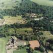
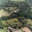
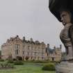
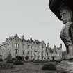
Newbattle Abbey House, Garden


Garden (Period Unassigned), Sundial(S) (Period Unassigned)
Site Name Newbattle Abbey House, Garden
Classification Garden (Period Unassigned), Sundial(S) (Period Unassigned)
Alternative Name(s) Newbattle Abbey Policies
Canmore ID 53440
Site Number NT36NW 15
NGR NT 3340 6604
Datum OSGB36 - NGR
Permalink http://canmore.org.uk/site/53440


- Council Midlothian
- Parish Newbattle
- Former Region Lothian
- Former District Midlothian
- Former County Midlothian
NT36NW 15 334 660.
(NT 3340 6608) S.D. (NR)
(NT 3343 6601) S.D. (NR)
OS 6" map (1932)
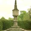
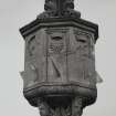
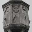
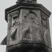
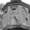
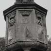
These are two exactly similar sundials, dating from 1635. They were moved from another part of the grounds to their present position before 1889. The modern octagonal pedestals rise from octagonal bases. The octagonal dial-stones are panelled in two tiers; the lower contains dials only, while the upper, as well as dials contains initials and arms of the Lothians.
T Ross 1890; RCAHMS 1929, visited 1920
These sundials, which are as described above, are still in position; they are both dated "1635".
Visited by OS (JFC) 13 September 1954
No change to previous field report.
Visited by OS (BS) 30 October 1975.
NMRS REFERENCE:
NMRS Print Room - Inglis Photograph Collection Acc no 1994/90
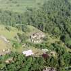
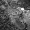
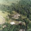
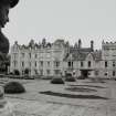
general view of the garden front, flowerbeds in foreground
formal garden
sundial
For the two identical facet headed sundials see NT36NW 14.07 and NT36NW 14.08.
In MS 5741/8/2 (1981) Dr Andrew Somerville notes that another sundial, lectern type with three half cylinders, is lying against the wall of the garden beside some other carved stones (A Cassells, 14 January 2010).
NT36NW 14.00 3335 6602 Newbattle Abbey House
NT36NW 14.01 33120 66349 Walled Garden
NT36NW 14.02 33188 66244 Orangery
NT36NW 14.03 33115 65881 Port Lodge
NT36NW 14.04 33114 65781 Riverside Cottages, stables
NT36NW 14.05 3 6 East Bridge
NT36NW 14.06 3 6 West Bridge
NT36NW 15.00 3340 6604 Garden and Sundial
NT36NW 16.00 3331 6604 Monk's Well
NT36NW 17.00 3316 6576 King David's Gate
NT36NW 18.00 3315 6574 King David's Well
NT36NW 20.00 331 657 Monkland Wall
NT36NW 21.00 3322 6614 St Mary's Church
NT36NW 22.00 3321 6619 Archbishop Leighton's house
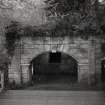
NT36NW 118 33317 65896 Grotto, Ice-house and grotto bridge
Photographic Survey (May 1954)
Photographic survey by the National Buildings Record Scottish Council in May 1954.

