
Pricing Change
New pricing for orders of material from this site will come into place shortly. Charges for supply of digital images, digitisation on demand, prints and licensing will be altered.
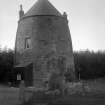
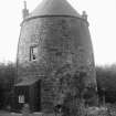
Edgehead, 'the Old Windmill'


Windmill (18th Century)
Site Name Edgehead, 'the Old Windmill'
Classification Windmill (18th Century)
Alternative Name(s) Chesterhill; Chesterhill Ford Village, Chester Hill
Canmore ID 53367
Site Number NT36NE 44
NGR NT 37180 65117
Datum OSGB36 - NGR
Permalink http://canmore.org.uk/site/53367


- Council Midlothian
- Parish Cranston
- Former Region Lothian
- Former District Midlothian
- Former County Midlothian
NT36NE 44 37180 65117.
The remains of a tower mill, converted in 1960 to form a dwelling house known as The Old Windmill.
I L Donnachie and N K Stewart 1967; G Douglas, M Oglethorpe and J R Hume 1984

