
Pricing Change
New pricing for orders of material from this site will come into place shortly. Charges for supply of digital images, digitisation on demand, prints and licensing will be altered.
Temple Church


Carved Stone(S) (Medieval), Church (Period Unassigned)
Site Name Temple Church
Classification Carved Stone(S) (Medieval), Church (Period Unassigned)
Alternative Name(s) Old Temple Kirk; Church Of The Knights Templars Of Balantrodach; Church Of The Hospitallers Of St John; Church Of The Knights Of St John
Canmore ID 53261
Site Number NT35NW 1
NGR NT 31526 58720
Datum OSGB36 - NGR
Permalink http://canmore.org.uk/site/53261


- Council Midlothian
- Parish Temple
- Former Region Lothian
- Former District Midlothian
- Former County Midlothian
NT35NW 1.00 31526 58720 Old Church
NT35NW 1.01 31516 58744 Church-yard
(NT 3151 5871) Temple Church (NR) (Remains of)
OS 6" map (1957)
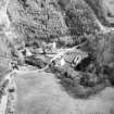
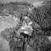
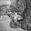
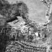
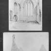
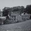
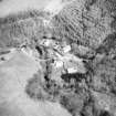
The modern 'Temple' is identical with 'Balantrodoch', the principal seat of the Knights Templars in Scotland. There is no record of its foundation, though it is commonly assumed that this was due to David I. The earliest reference is probably in a charter of 1175-99. After the suppression of the Templars, about 1309, "Temphill of Balantrodoch with the kirk" became one of the baronies held by the Hospitallers, while, at an unascertained date, the former Templars' church became parochial. That church was in use until the present church (at NT 3151 5878) was built, in 1832, and still exists in ruins.
The church (dedicated to the Virgin Mary, as were all Templars' churches) was a single-chambered oblong structure, 54 3/4 ft x 17 3/4 ft internally. The E part, of ashlar, dates from the end of the 13th c, while the W part has been rebuilt. An earlier building probably occupied the site as several courses of 12th c masonry were re-used in the later portion. It is roofless, but the walls are complete, and the E gable is topped by a 17th c belfry.
In 1853, the manse was believed to occupy the site of the associated 'Templars' house', and during alterations to it in 1928, a drainage track exposed the basement course of a 13th c building which ran N-S at a distance of 80ft W of the W gable of the church. This structure was part of the claustral buildings, the cloister evidently having been on the N side of the church due to the constricted nature of the site. The foundations of a wall and buttress at the bend of the river, S of the manse, may be the remains of the reredorter. A cellar beneath the manse, containing the lower part of a small wheel-stair, may indicate the N range of the cloister.
D E Easson 1957; RCAHMS 1929, visited 1928; Name Book 1853; G Hay 1957
When visited in 1954, the roofless, much restored, remains of the church were as described above. The 13th c E gable was in good condition. The foundations and buttress mentioned above were not visible.
Visited by OS (JFC) 10 September 1954.
NMRS REFERENCE
Non-Guardianship Sites Plan Collection, DC28797.
Pamphlet containing text and photographs
EXTERNAL REFERENCE
National Library of Scotland
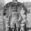
Country Life, 24 April 1942, letter concerning tombstone
Aliaga-Kelly, C, 'Discovery & Excavation in Scotland' 1985, pp. 29 - 30 (missing from library shelves)
Photographic Survey (1986)
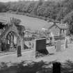
Recording of gravestones in Temple Churchyard by Mrs Betty Willsher in 1986.
Ground Survey (1 July 2009)
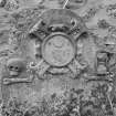
NT 31505 58728 Following the discovery of two carved stone slabs during the reconstruction of the churchyard
wall at Temple, a programme of recording was undertaken in July 2009. Temple, formerly called Balantrodoch, was the principal seat of the Knights Templar in Scotland. The design of the stones and the association with the Knights Templar suggest a 12th- or 13th-century date.
The work involved recording the position of the stones, drawing and photographing them and recording the base and section of the foundation trench excavated for the reconstruction of the wall. The work also aimed to try and determine if the stone slabs overlay grave cuts. A dip in the level of the subsoil was recorded in the vicinity of the stones, but the evidence for a grave-cut was inconclusive.
Archive: Midlothian Council SMR and RCAHMS
Funder: Midlothian Council
Magnus Kirby – CFA Archaeology Ltd

