Pricing Change
New pricing for orders of material from this site will come into place shortly. Charges for supply of digital images, digitisation on demand, prints and licensing will be altered.
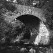
Ettrick Bridge
Road Bridge (18th Century)
Site Name Ettrick Bridge
Classification Road Bridge (18th Century)
Alternative Name(s) Ettrick Water; Ettrickbridge; Ettrickbridge End
Canmore ID 53087
Site Number NT32SE 3
NGR NT 39022 24270
Datum OSGB36 - NGR
Permalink http://canmore.org.uk/site/53087
- Council Scottish Borders, The
- Parish Kirkhope
- Former Region Borders
- Former District Ettrick And Lauderdale
- Former County Selkirkshire
NT32SE 3 39022 24270
(NT 39012427) Ettrick Bridge (NAT)
OS 6" map (1900)
Ettrick Bridge. Over the rocky gorge at the E. end of the village of Ettrickbridge End Sir Walter Scott of Harden built a bridge of three arches in 1628, and on the front of it he set a panel with his cost of arms.
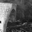
The design was faulty, and by 1715 the bridge was already ruinous; but it was not until 1780 that it was replaced by the present bridge of a single span. In 1858 this new bridge was widened on the downstream side. About 3 ft. below the parapet on the older, or upstream, side of the bridge, Harden's panel has been rebuilt into the masonry. Not all of its details can be read from the river bank, but a drawing of it made many years ago (T Craig-Brown 1886) shows the shield surmounted by a scroll and charged: On a bend a star of six points between two crescents, and in sinister chief a rose, stalked and barbed. Flanking the shield are the initials (W) S, for Sir Walter Scott of Harden, and below M E, perhaps recut, as they are incised, for Margaret Edgar of Wedderlie, his second wife. Below these again comes the date 1628 followed in Craig- Brown's drawing by a monogram of the initials P M, possibly those of the mason. At the top of the margin round the panel the date 1780 is carved.
RCAHMS 1957, visited 1 July 1946.
Ettrick Bridge is as described by RCAHMS. The 'Harden' panel is on the restored, upstream, side, and there is an '1858' date stone on the downstream side.
Visited by OS (JLD) 6 June 1962.
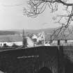
(Location cited as NT 390 243). Ettrick Bridge, Ettrickbridge, built 1780. A single-segmental rubble arch, with one end butting on to solid rock.
J R Hume 1976.
This bridge carries the B7009 public road over the Ettrick Water immediately E of Ettrickbridge village (NT32SE 21).
Information from RCAHMS (RJCM), 3 November 2009.
Ettrick Bridge [NAT]
OS (GIS) MasterMap, November 2009.
Sbc Note (15 April 2016)
Visibility: Standing structure or monument.
Information from Scottish Borders Council


