
Watch Knowe, Caerlanrig


Fort (Period Unassigned)
Site Name Watch Knowe, Caerlanrig
Classification Fort (Period Unassigned)
Alternative Name(s) Caerlanrig
Canmore ID 53011
Site Number NT30SE 2
NGR NT 3987 0490
Datum OSGB36 - NGR
Permalink http://canmore.org.uk/site/53011


- Council Scottish Borders, The
- Parish Teviothead
- Former Region Borders
- Former District Roxburgh
- Former County Roxburghshire
NT30SE 2 3987 0490.
(NT 3987 0490) Fort (NR)
OS 6" map (1923)
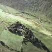
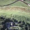
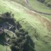
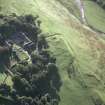
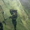
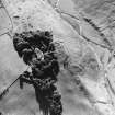
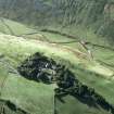
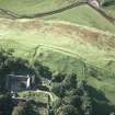
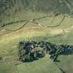
Fort, Watch Knowe, Caerlanrig. The fragmentary remains of a fort are situated a few yards N of Caerlanrig farmhouse, on a ridge overlooking the right bank of the River Teviot from a height of 730 ft OD. The descent from the ridge to the river, 200 ft below, is steep, but in all other directions the slopes are gentle. The remains csonsist of a stony, grass-covered bank about 3 ft high, with an external ditch, which runs from NE to SW along the axis of the ridge. The NE end of the bank can be seen to curve to the SE before it dies out, but most of the NE end and the whole of the SE side and the SW end of the fort have been obliterated. The total length was originally about 250 ft.
The situation and appearance at the remains suggest that they are those of a ridge-fort of conventional type.
RCAHMS 1956, visited 1948
Ridge Forts - a specialised class of IA hillfort.
RCAHMS 1956
The remains of the fort are generally as described by RCAHMS. No trace was seen of the grass-covered bank 3 ft high, as mentioned, except for a short stretch on the NE side, where it is 0.3m internal height. The ditch, 0.4m maximum depth, runs along the base of a steep scarp, c.
3.0m high, which appears to be natural and composed of earth with occasional stretches of outcrop rock showing through. The counterscarp of the ditch has a slight mound on top evident for c. 38.0m, but this may be the result of the silting up of the soil along the base of the fence which follows the line of this side of the ditch.
Revised at 6".
Visited by OS (EGC) 19 July 1962
Note (3 August 2015 - 24 May 2016)
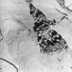
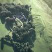
The remains of what may have been a fort or a fortified settlement are situated immediately N of Caerlanrig, which stands on the NE end of a long ridge in the headwaters of the River Teviot. The defences have been heavily degraded, apparently comprising a single rampart and ditch, though little of the rampart is visible. The ditch can be traced for a distance of some 65m along the crest of the slope dropping steeply down to the River Teviot on the NW, set at the foot of a largely natural scarp some 3m high. At the NE end the ditch and traces of the inner rampart turn in an arc through almost 90 degrees before petering out on the NE side, while at the SW end a later ditch appears to cut sharply back at right-angles towards the farm. In 1858 the first OS surveyors to depict the earthworks completed the circuit of the ditch on the NE and SE with a dashed line to create a rectilinear enclosure measuring internally about 75m from NE to SW by 50m transversely (0.38ha). Apart from the NW flank, however, there are no compelling topographical features to limit the size of the enclosure. While described by RCAHMS as a ridge fort, a type where the topography has created a roughly rectilinear plan (RCAHMS 1956, 18), it might equally be described as a strongly enclosed rectilinear settlement. If extending beyond the area shown by the first OS surveyors, it would probably embrace the cottage gardens in which an aureus of Vespasian was discovered in 1856 (RCAHMS 1956, 441, no.992; Canmore 53015); the Wilton Lodge Museum, Hawick also holds a perforated stone disc (HAKMG 4247; Canmore 53017) from Caerlanrig.
Information from An Atlas of Hillforts of Great Britain and Ireland – 24 May 2016. Atlas of Hillforts SC3240
Field Visit (5 January 2016)
NT3987 0490
The re-classification of the earthwork in the pass of Ewes Doors as a Roman watchtower (NY39NE 4) and the recognition that this overlooked the course of the Roman road passing into Teviotdale (NY39NE 29), led to a re-evaluation of the remains at Watch Knowe, Caerlanrig (NT30SE 2), as a source for the military detachment that serviced this small military post. Apart from the evocative place-name, its strong position at the end of a ridge on the potential line of the Roman road and the fact that a coin of Vespasian had been discovered thereabouts in the 19th century, recent aerial photographs from 2015 supplied by Get Mapping showed what appeared to be the well-preserved rounded NE corner of a possible Roman fort or fortlet immediately N of the farm buildings (NY 3990 04922). However, this was a chimera, the ‘corner’ consisting of a natural feature, a field bank and a trackway, while the zone confined by it to the SE enclosed traces of quarrying and building platforms associated with the farm.
Visited by HES, Survey and Recording (ATW, GFG, HGW) 5 January 2016
Sbc Note
Visibility: This is an upstanding earthwork or monument.
Information from Scottish Borders Council

